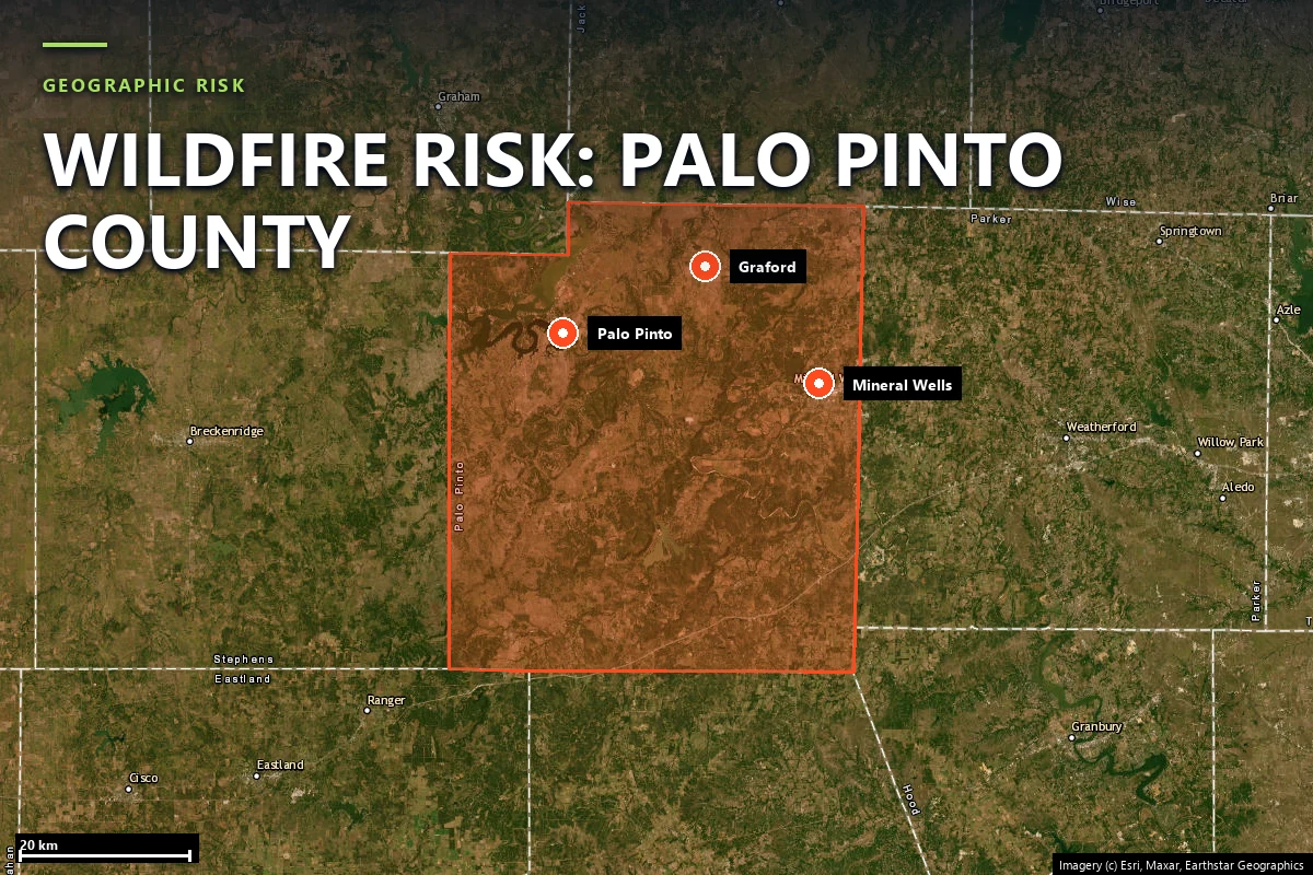
Wildfire risk in Palo Pinto County: a low parcel score with a moderate community constraint
Our Satelife report for Park Road 36 near Graford returns
23.55 / 100 — Low, with 0.0% modelled probability of
flames over four feet. The community analysis is the sharper warning:
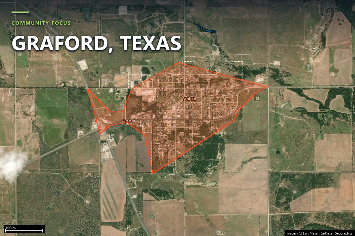
31.37 / 100 Moderate, with 160 structures behind only
nine exits and a 47.2-metre single point of failure.
The county where lake-country recreation became a structure-loss fire story
Palo Pinto County sits where North Texas grass, brush, reservoir shoreline development and Cross
Timbers tree cover start to overlap. Graford and the Possum Kingdom side of the county are the most
visible wildfire interface because they concentrate homes along irregular roads, steep banks and
coves rather than across a square rural grid.
The modern reference event is the 2011 Possum Kingdom Complex, which burned roughly
126,000 acres and destroyed 168 homes. That acreage is not just a
historical footnote. It explains why a county whose current case-study parcel scores low still needs
a community page: the structure-loss pattern here is about where homes sit in relation to water,
vegetation and access, not just about one parcel’s standing fuel today.
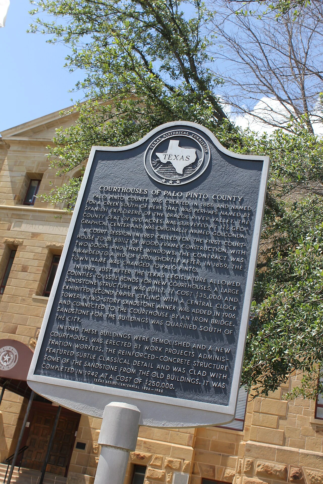
Palo Pinto County’s older civic core — a reminder that the wildfire exposure is concentrated more
heavily in the reservoir and dispersed-lot interface than in the historic town center. Source:
Wikimedia Commons
(CC BY 2.0).
Sources: regional reporting and public-agency summaries of the 2011 Possum Kingdom Complex; parcel
and community figures from Satelife reports generated 25 July 2026.
Terrain & fuel
The parcel itself is calm; the lake-country road pattern is not
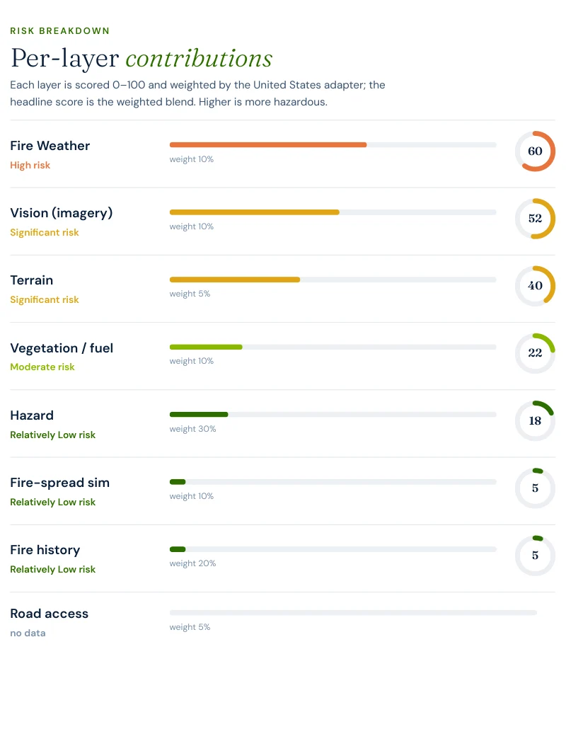
The Park Road 36 property reads as a relatively quiet parcel on the layers that usually dominate a
Texas headline. Climate is 60.4 / 100, vision 52 / 100, terrain
40 / 100, vegetation 22.4 / 100, hazard 18.0 / 100,
and both fire-spread simulation and fire history score 5 / 100. That is how a lake
country property lands at 23.55 overall instead of much higher.
That quiet parcel result is why this page has to pivot quickly to the neighborhood run. Palo Pinto’s
exposure is not best understood as “this lot has extreme fuel.” It is better understood as “a lot of
homes share a small number of ways out in a landscape that has already shown it can produce major
structure loss.”
Evacuation
Nine exits, one station, and a 47.2-metre bottleneck
The neighborhood analysis is the page’s main finding. It looks nothing like the parcel-level calm.
160structures in the analyzed community footprint
9independent exits across 161.8 hectares
17.78structures per exit route
47.2 msingle point of failure detected on the network
1OSM-mapped fire station serving the analyzed area
0.3 minfastest modelled engine time; hotspot zones at 0.9–1.9 minutes
That combination is unusual. The first engine is extremely close, yet the community is still exit-
constrained. Palo Pinto’s problem is not reach time in the abstract. It is how much development is
stacked behind how few routes once a reservoir-edge settlement begins to fill in.
Report excerpt — Road access: suppression reach & egress, Satelife Wildfire
Risk Report, Park Road 36, Graford TX 76449 (July 2026). Drive-times are modelled on the public
road graph and OSM-mapped stations; decision support, not an evacuation plan.
Hazard framing
Low at the lot, moderate in the neighborhood, because roads and structure density scale differently
The key Palo Pinto contrast is numerical and direct. The property score is 23.55 Low.
The neighborhood score is 31.37 Moderate. The federal flame-length model stays at
0.0% for both four-foot and eight-foot exceedance at the parcel. The shift upward at
community scale is therefore not a hidden fuel story. It is an access-and-density story.
23.55property composite score — Low tier
31.37community score — Moderate tier
52AI vision layer — the property’s highest score
0.0%probability of flames over 4 ft and over 8 ft
This is what makes Palo Pinto County different from the other new Texas pages. Kendall and Comal are
low because the parcel and the community both stay fairly forgiving. Hays is moderate because access
is already biting at the parcel scale. Palo Pinto is the one where the wider neighborhood geometry is
materially more concerning than the single lot you might be buying.
In Palo Pinto County the lot can look calm while the settlement pattern around it does not.
Case study
One address on Park Road 36, scored today
We ran a full Satelife wildfire-risk report for a property on Park Road 36, Graford TX
76449. The composite returns 23.55 / 100 — Low tier, at
0.74 confidence.
Report excerpt — Per-layer contributions, Satelife Wildfire Risk Report, Park
Road 36, Graford TX 76449 (25 July 2026). Composite 23.55/100, Low tier, scored under the United
States (usa_generic) adapter.
What drives the score:
Climate: 60.4 / 100. The highest scalar in the property report.
Vision: 52 / 100. The imagery read sees meaningful vegetation and exposure around the structure.
Terrain: 40 / 100. Enough relief to matter without forcing a higher tier on its own.
Vegetation: 22.4 / 100 and hazard 18.0 / 100. The key reasons the parcel stays Low.
Road access: 0 / 100. The lot itself is not the access problem; the surrounding community is.
The report-backed answer for Graford is split: maintain the parcel, but do not confuse parcel calm
with community resilience.
The mitigation plan is correspondingly conservative at the lot scale:
maintain current defensible space and home hardening. The larger operational issue
remains the shared road network.
Insurance & real estate
Lake-country property needs a community reading, not just a parcel reading
Palo Pinto County is a good example of why county and neighborhood pages exist alongside parcel
reports. A buyer looking at reservoir-edge property can easily understand the lot and still miss the
fact that the surrounding settlement has only nine exits for 160 structures. Texas offers no official
wildfire hazard zone map to fill that gap for them.
There is also no statewide mitigation-discount rule that converts defensible space into a guaranteed
premium break. Underwriters can respond to documentation; they are not required to use one common
Texas wildfire schedule. If admitted coverage fails, the backstop is the Texas FAIR Plan
Association, available only after at least two carriers writing in Texas decline comparable
coverage.
For Palo Pinto property specifically, the useful diligence document is the one that pairs the parcel
score with the neighborhood geometry. The latter is the part listing photos and county averages do
not tell you.
Sources: Texas Department of Insurance · Texas FAIR Plan Association · Texas Property Code §5.008.
Risk reduction
What Palo Pinto County homeowners can actually do
The property-level prescription is standard: keep the first five feet ember-resistant, preserve lean
and open defensible space, and keep the structure hardened. The community-level prescription is less
personal and more strategic: understand which exit you are actually likely to use and how many other
homes are behind it.
The best comparison is
Comal County. Graford’s
community analysis shows 17.78 structures per exit; Bulverde’s shows
1.04 structures per exit. Both pages publish low parcel scores. The difference is
that Comal’s roads are currently generous for the number of homes using them, while Palo Pinto’s are
already carrying a much tighter load.
Coverage
ZIP codes we cover in Palo Pinto County
Satelife runs address-level wildfire reports across every ZIP code in Palo Pinto County.
The ZIPs below are the Cross Timbers, lake-country interface and Wildland-Urban Interface
communities we are asked about most. One caveat that is the whole point of what we
do: the risk score is computed for your parcel, not the ZIP, so two
homes on the same street can land in different tiers. Find your area, then
run your address.
ZIP code
Community
Why it is on the map
76449
Graford
Park Road 36 case study near the Possum Kingdom lake-country interface
76484
Palo Pinto
County seat and rural ranchland corridor
76067
Mineral Wells
Largest population center on the county’s east side
76475
Strawn
Southwestern county grass and ranch fuels
ZIP areas per USPS. Texas publishes no statewide fire hazard severity zone map; Wildland-Urban Interface framing per Texas A&M Forest Service.
Frequently asked questions about Palo Pinto County wildfire risk
Is Palo Pinto County a high wildfire risk county?
The property we scored is not. A Satelife report for Park Road 36 near Graford returns 23.55 / 100 in the Low tier, with 0.0% probability of flames over four feet and over eight feet. But the neighborhood analysis is higher at 31.37 / 100 Moderate because 160 structures sit behind only nine exits, with a 47.2-metre chokepoint on the modeled network. In Palo Pinto County the community geometry is worse than the parcel headline.
What major wildfire history matters in Palo Pinto County?
The big modern reference is the 2011 Possum Kingdom Complex in and around Palo Pinto County, which burned roughly 126,000 acres and destroyed 168 homes according to contemporaneous regional reporting and Texas Parks and Wildlife sources. That event is the county-scale reminder that the lake-country interface can turn from recreation landscape to structure-loss landscape very quickly.
Why is the neighborhood score Moderate if the property score is Low?
Because the community has a much tighter exit picture than the parcel. The Graford-area analysis finds 17.78 structures per exit route, one mapped station, and a 47.2-metre single point of failure. Those are community-scale constraints, and they can dominate even when the specific lot does not carry extreme vegetation or hazard numbers.
How fast is fire response in the Graford case study?
Very fast for the first engine and not very redundant. The community analysis finds one mapped station with a 0.3-minute fastest modeled response, and hotspot zones at 0.9 to 1.9 minutes. That is excellent initial reach, but it is still one-station geometry.
What mitigation does the Park Road 36 report recommend?
Maintain current defensible space and home hardening. The parcel itself is presently a Low-tier case; the larger concern is how many homes share how few exits in the surrounding lake-country road network.
Scores and evacuation figures on this page are drawn from Satelife wildfire-risk reports generated on
25 July 2026 under the United States (usa_generic) adapter: a property report for Park Road
36, Graford TX 76449, and a community analysis for the Graford-area case study. Texas publishes no
statewide fire-hazard-severity map, so the hazard layer is backfilled from the USFS Wildfire Risk to
Communities model. The 2011 Possum Kingdom Complex figures are contextual public-source history, not a
direct scored input to the report. Drive-times are modelled on OSM-mapped stations and the current road
graph. Satelife reports are informational decision support — not a substitute for official evacuation
orders, state or federal hazard determinations, or an insurer’s underwriting judgment.
What does your Palo Pinto County parcel look like, layer by layer?
If you own or are buying in Palo Pinto County — Graford, Palo Pinto, Mineral Wells or Strawn — get the address-level answer: PDF, per-layer score, and a prioritized mitigation plan.