Wildfire risk in Comal County: Bulverde and a growth corridor that is still mostly low
Our Satelife report for Bulverde Road returns 20.62 / 100 — Low,
with 0.0% modelled probability of flames over four feet. The wider community
analysis also stays Low at 24.81 / 100, while finding an
unusually strong exit ratio: 120 exits for 125 structures.
Comal County’s wildfire story is less about one blaze than about how fast the edge is moving
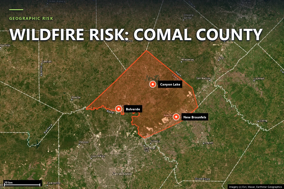
Comal County sits between San Antonio and Austin at exactly the point where interstate growth,
Hill Country terrain and reservoir recreation all start to overlap. New Braunfels anchors the east;
Bulverde, Spring Branch and Canyon Lake carry the western and northwestern Wildland-Urban Interface.
This is a county where the settlement pattern itself is the signal: more houses, more private roads,
more gate-controlled subdivisions and more ignition exposure pushed into oak-juniper cover.
KSAT reported in 2025 that Bulverde-Spring Branch population growth was driving
wildfire-readiness planning in Comal County. The report-backed numbers on this page support that
framing. The current case-study parcel is not severe. The county-level problem is making sure a low
score today does not become a harder evacuation and access problem after another decade of buildout.
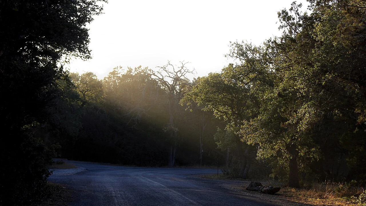
Guadalupe River State Park, Comal County — the oak-juniper landscape west of the fast-growing
Bulverde-Spring Branch corridor. Source:
Wikimedia Commons
(CC BY 4.0).
Sources: KSAT reporting on Comal County wildfire-readiness planning; parcel and community figures
from Satelife reports generated 25 July 2026.
Terrain & fuel
A Hill Country parcel that stays low because hazard and access are still favorable
The Bulverde Road property does not read like an extreme fuel bed. Climate is
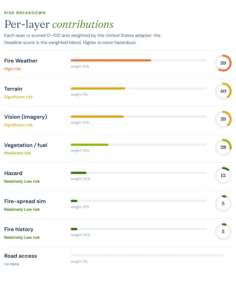
59.1 / 100, terrain 40 / 100, vision 39 / 100 and
vegetation 27.8 / 100 — a recognizable Hill Country profile, but not an escalated
one. Hazard reads only 11.7 / 100, and both fire-spread simulation and fire history
return 5 / 100.
The useful takeaway is that Comal County does not need to look extreme to deserve planning. A low
score in a high-growth corridor is the kind of result that supports proactive mitigation, because the
economics of preservation are far better than the economics of retrofit.
Evacuation
One of the best exit ratios on any Texas page we publish
The neighborhood run is unusually strong. Most Texas WUI communities show a clear tradeoff between
structure count and exit redundancy. The Bulverde-area case study does not show that tradeoff nearly
as strongly.
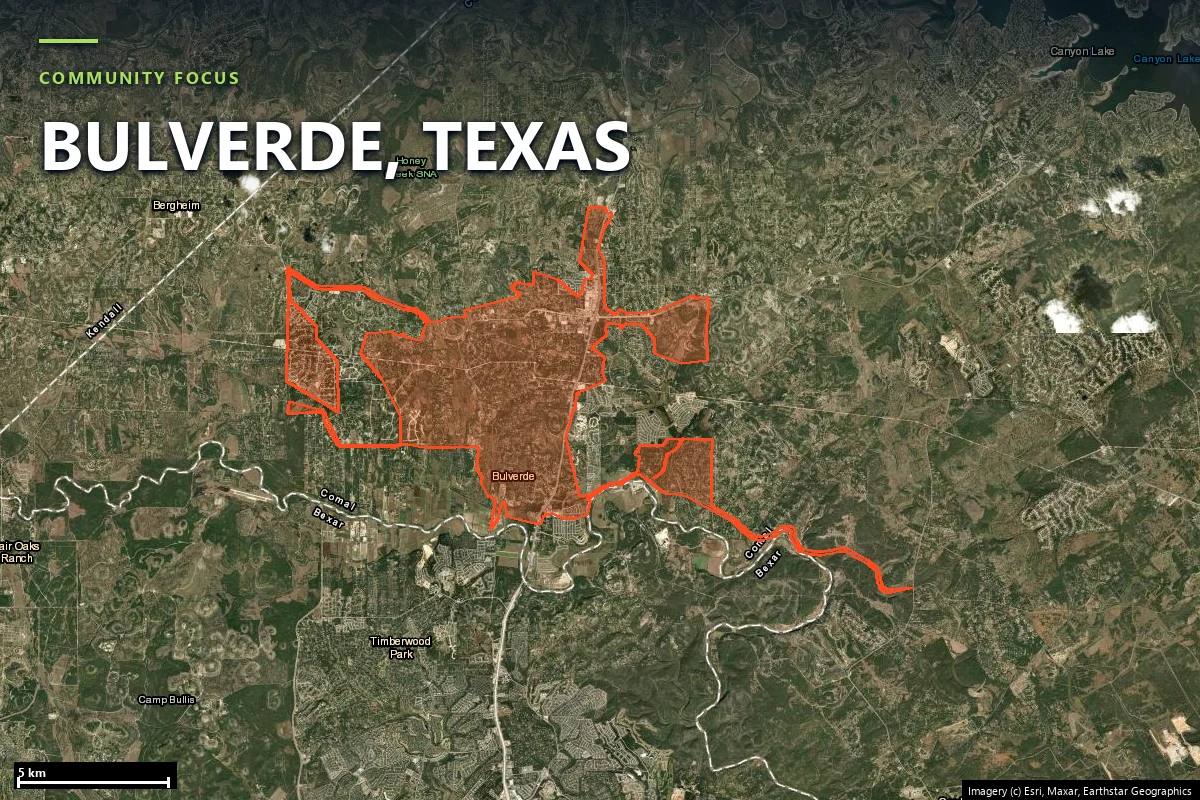
125structures in the analyzed community footprint
120independent exits across 5,523.1 hectares
1.04structures per exit route
4fire stations within the search radius
9.3 minfastest modelled engine time
2.1–6.1 minmodelled hotspot-zone drive-times
The parcel-level road-access layer is 0 / 100, and the community run did not
return a non-null single-point-failure width. Together those numbers say the current network is not
the binding constraint at this location. The county’s planning problem is therefore not “find the
obvious choke” so much as “keep future subdivision growth from creating one.”
Report excerpt — Road access: suppression reach & egress, Satelife Wildfire
Risk Report, Bulverde Road, Bulverde TX 78163 (July 2026). Drive-times are modelled on the public
road graph and OSM-mapped stations; decision support, not an evacuation plan.
Hazard framing
Low today, but only if growth does not outrun readiness
The Bulverde property scores 20.62 / 100 Low because the layers that carry the most
weight remain modest: hazard 11.7, vegetation 27.8, road access 0, and 0.0% modeled probability of
flames over both four feet and eight feet. That is real good news.
20.62property composite score — Low tier
24.81community score — Low tier
11.7hazard layer — unusually low for a Hill Country page
0.0%probability of flames over 4 ft and over 8 ft
The reason to publish the page anyway is the county trajectory. Comal is where a low-score result
and a high-growth planning story meet. If readiness work keeps pace with development, this is the
kind of county that can remain mostly manageable. If it does not, the numbers that are forgiving now
are the ones most likely to deteriorate gradually rather than all at once.
Comal County is a growth-management wildfire page: less about dramatic current fire behaviour, more
about not building tomorrow’s evacuation problem into today’s low score.
Case study
One address on Bulverde Road, scored today
We ran a full Satelife wildfire-risk report for a property on Bulverde Road, Bulverde TX
78163. The composite returns 20.62 / 100 — Low tier, at
0.78 confidence.
Report excerpt — Per-layer contributions, Satelife Wildfire Risk Report,
Bulverde Road, Bulverde TX 78163 (25 July 2026). Composite 20.62/100, Low tier, scored under the
United States (usa_generic) adapter.
What drives the score:
Climate: 59.1 / 100. The largest single numerical pressure in the report.
Terrain: 40 / 100 and vision 39 / 100. Enough relief and vegetation presence to matter, but not enough to force the score higher.
Vegetation: 27.8 / 100. Real Hill Country fuel, still moderate.
Hazard: 11.7 / 100. A low backfilled hazard read is a major reason the composite stays Low.
Road access: 0 / 100. The property approach is currently a strength, not a weakness.
Bulverde is the rare Texas page where both the parcel and the community score low and the report is
still worth reading because growth, not current flame intensity, is the strategic issue.
The mitigation plan is therefore conservative and maintenance-oriented:
maintain current defensible space and home hardening.
Insurance & real estate
A low score is still valuable in a county that is adding homes fast
Comal County buyers face the same Texas structural gap as buyers anywhere else in the state: no
statewide wildfire hazard map, no wildfire disclosure item on the standard seller form, and no
statutory mitigation-discount ladder they can cite to an insurer. That makes locally specific,
parcel-level evidence unusually valuable.
In a fast-growing county, a low report can be commercially useful in two directions at once. It can
document that a property is currently in good condition for underwriting purposes, and it can anchor
a buyer’s expectation of what they need to preserve as surrounding growth changes traffic, access and
vegetation management on adjacent land.
If admitted coverage fails, the fallback remains the Texas FAIR Plan Association,
available only after two active carriers decline comparable coverage.
Sources: Texas Department of Insurance · Texas FAIR Plan Association · Texas Property Code §5.008.
Risk reduction
What Comal County homeowners can actually do
For Comal County, the right mitigation posture is preservation. Keep Zone 0 clean and ember-resistant,
keep tree limbs and shrubs off the structure envelope, and keep access usable for apparatus as nearby
lots fill in. Because the current road result is good, the strategic error would be letting later
subdivision decisions erode the condition the report is measuring today.
The useful comparison is
Hays County. Bulverde’s
community analysis shows 1.04 structures per exit with four stations in range;
Wimberley’s shows 4.28 structures per exit with one station. Both are central Texas
Hill Country communities. Comal’s advantage today is not dramatically lower climate pressure. It is
cleaner road redundancy.
Coverage
ZIP codes we cover in Comal County
Satelife runs address-level wildfire reports across every ZIP code in Comal County.
The ZIPs below are the Hill Country and Wildland-Urban Interface
communities we are asked about most. One caveat that is the whole point of what we
do: the risk score is computed for your parcel, not the ZIP, so two
homes on the same street can land in different tiers. Find your area, then
run your address.
ZIP code
Community
Why it is on the map
78163
Bulverde
Bulverde Road case study and the county’s northwestern growth edge
78070
Spring Branch
US-281 corridor and fast-growing Hill Country subdivisions
78133
Canyon Lake
Reservoir-edge WUI with complex cove and road geometry
78130
New Braunfels
South and east county growth front
78132
New Braunfels / north side
Westward expansion into Hill Country terrain
ZIP areas per USPS. Texas publishes no statewide fire hazard severity zone map; Wildland-Urban Interface framing per Texas A&M Forest Service.
Frequently asked questions about Comal County wildfire risk
Is Bulverde a high wildfire risk area?
The case-study property we published is not. A Satelife report for Bulverde Road returns 20.62 / 100 in the Low tier, with 0.0% modelled probability of flames over four feet and over eight feet. The wider community analysis is also Low at 24.81 / 100. What makes Comal County worth tracking is not a severe current score; it is the speed of growth into Hill Country vegetation and the need to keep road and parcel conditions from degrading as that growth continues.
Why does Comal County show up in wildfire-readiness planning?
Because the Bulverde-Spring Branch side of the county is growing fast. KSAT reported in 2025 that population growth in that corridor was driving wildfire-readiness planning in Comal County. This page’s report numbers fit that framing: not extreme fire behaviour today, but a landscape where planning early is cheaper than retrofitting later.
How many exits does the Bulverde community analysis have?
It is one of the strongest egress results on any Texas county page we publish: 120 exits for 125 structures, or 1.04 structures per exit, across 5,523.1 hectares. The model did not return a non-null single-point-failure width on this run, so the main story is exit redundancy rather than one detected bottleneck.
Does Texas give Comal County addresses an official wildfire zone?
No. Texas publishes no statewide fire hazard severity zoning system. Satelife therefore backfills the hazard layer from the U.S. Forest Service Wildfire Risk to Communities model; at the Bulverde property it reads only 11.7 / 100, which is a major reason the overall score stays Low.
What mitigation does the Bulverde property report recommend?
Maintain current defensible space and home hardening. Like Kendall County, this is a “preserve a good condition” result rather than a “correct a major existing deficiency” result.
Scores and evacuation figures on this page are drawn from Satelife wildfire-risk reports generated on
25 July 2026 under the United States (usa_generic) adapter: a property report for Bulverde
Road, Bulverde TX 78163, and a community analysis for the Bulverde-area case study. Texas publishes no
statewide fire-hazard-severity map, so the hazard layer is backfilled from the USFS Wildfire Risk to
Communities model. The Bulverde-Spring Branch growth reference comes from local reporting and is used
only as planning context, not as a scored report input. Drive-times are modelled on OSM-mapped stations
and the current road graph. Satelife reports are informational decision support — not a substitute for
official evacuation orders, state or federal hazard determinations, or an insurer’s underwriting
judgment.
What does your Comal County parcel look like, layer by layer?
If you own or are buying in Comal County — Bulverde, Spring Branch, Canyon Lake or New Braunfels — get the address-level answer: PDF, per-layer score, and a prioritized mitigation plan.