Our Satelife report for Wasp Creek Road near Boerne returns 24.73 / 100 — Low, with 0.0% modelled probability of flames over four feet. The same property scores 75 / 100 on AI vision, reflecting trees close to the structure, and the Boerne-area community analysis still detects a 15.9-metre chokepoint on a network serving 161 structures.
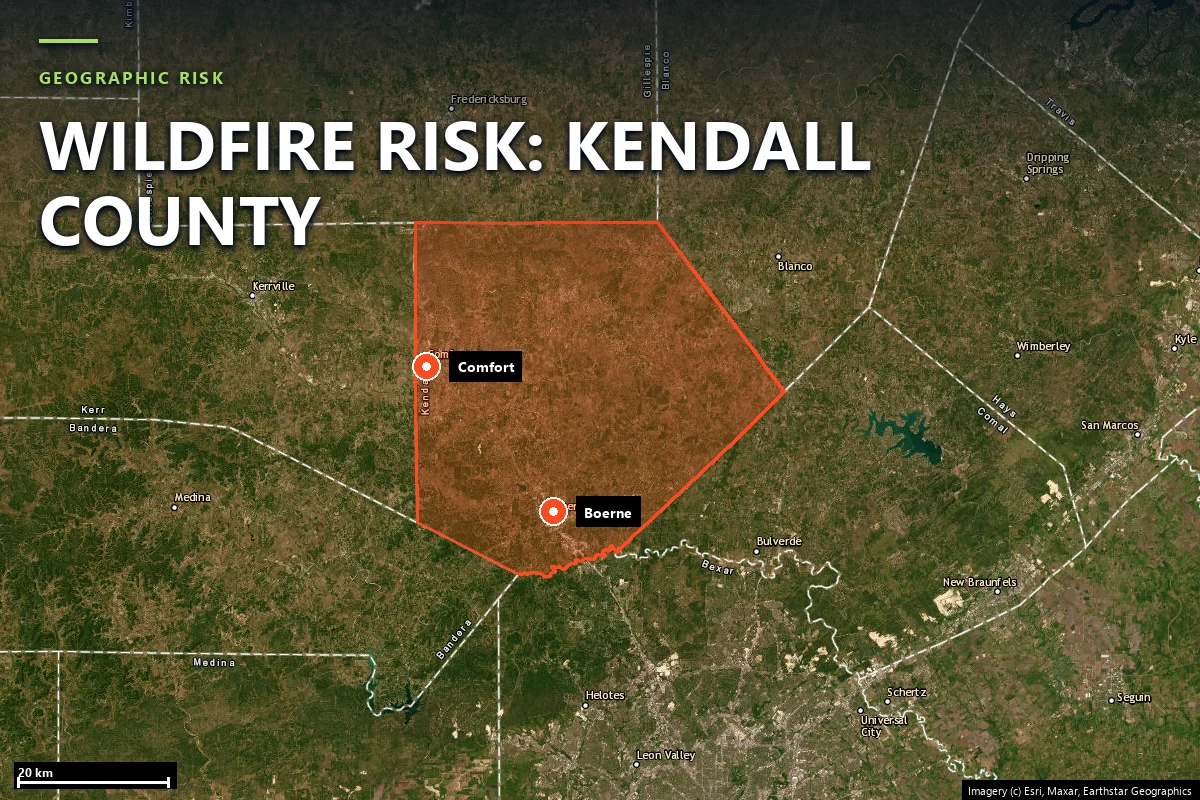
Kendall County is one of the fast-growing western edges of Greater San Antonio: Boerne on the Interstate 10 corridor, Fair Oaks Ranch on the south edge, rural ranchettes and gated streets extending north and west into live oak, juniper and creek-drainage terrain. The county does not have one universally recognized named fire in the way Bastrop or Hutchinson does. That is not a weakness in the page; it is the point. In Kendall County the underwriting question is often not “did this exact subdivision burn in a headline event?” but “what does this parcel look like now, and what happens if a wind-driven grass-and-brush start reaches it?”
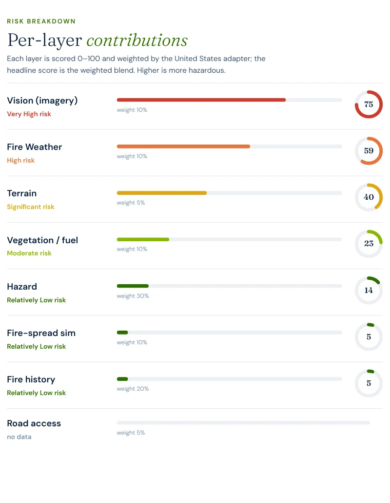
That is why the Boerne property run is useful. It reads present-tense exposure rather than trying to force the county into a famous-incident template: climate at 59.2 / 100, terrain at 40 / 100, vision at 75 / 100, and a community road network that is broadly redundant but not perfectly wide all the way through.
Sources: Kendall County growth pattern and local geography from county and regional planning materials; parcel and community figures from Satelife reports generated 25 July 2026.
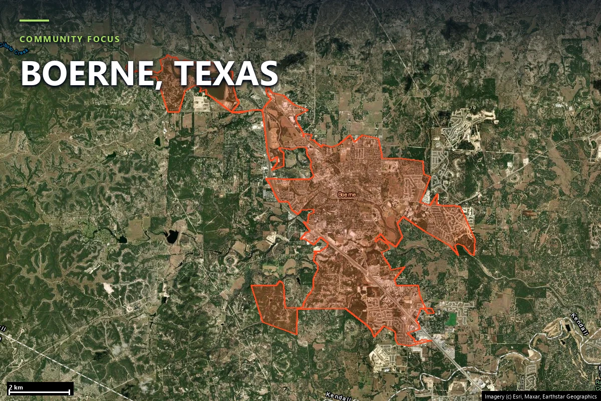
The Boerne close-up makes the pattern visible: houses cut into Hill Country vegetation rather than replacing it. The property report’s highest layer is the AI vision score at 75 / 100, meaning the imagery read sees mature trees and combustible landscaping close enough to the structure to matter even though the broader fuel model is not extreme. The climate layer at 59.2 / 100 and terrain at 40 / 100 push in the same direction.
The layers that keep the score low are the ones Texas property owners need to interpret carefully. Vegetation/fuel reads only 23.3 / 100, hazard 14.2 / 100, fire-spread simulation 5 / 100, fire history 5 / 100, and road access 0 / 100 at the parcel itself. In other words: the fuel bed immediately around this address is not what a Panhandle grass parcel or a burn-scar subdivision looks like. The reason to keep the page is not that the property is already severe. It is that the structure sits in a landscape that can become harder to defend if tree density and access discipline drift.
The community-scale analysis is more reassuring than many Texas county pages we have published, and it is still not perfect. Across the analyzed Boerne-area footprint, Satelife finds 109 independent exits for 161 structures — a much stronger ratio than the tighter lake and canyon communities elsewhere in the Hill Country.
Read the exits and the chokepoint together. Kendall County’s case study is not a one-road peninsula like Steiner Ranch and not a nine-exit reservoir settlement like Graford. It is a relatively healthy network that still narrows enough to matter if one stalled vehicle, one gate, or one shoulder fire takes away the wrong segment at the wrong time.
The cleanest way to understand Kendall County’s case study is to start with what the federal fire behaviour layer does not say. At this parcel, the USFS-modelled probability of flames over four feet is 0.0%; over eight feet it is also 0.0%. That is why the composite lands at 24.73 / 100 Low instead of in the Moderate band.
The consequence is straightforward. Kendall County’s published story is less about current flame intensity than about maintaining a low-risk condition in a growth corridor that is steadily moving outward into the same wooded terrain the vision layer sees so clearly. A low score is not a reason to stop maintaining the lot. It is evidence that the lot is worth maintaining.
We ran a full Satelife wildfire-risk report for a property on Wasp Creek Road, Boerne TX 78006. The composite returns 24.73 / 100 — Low tier, at 0.82 confidence, from eight independently scored and weighted layers.
usa_generic) adapter.
What drives the score:
The mitigation plan reflects that posture: maintain current defensible space and home hardening. This is one of the few Texas case studies where the recommendation is to hold a good line rather than to correct an obvious failure.
Kendall County sits in exactly the kind of Texas market where wildfire diligence matters more than the statute book. Buyers are looking at custom homes, acreage lots and fast-appreciating western fringe property, but the state gives them no wildfire zone designation to check and no seller form that names one. Texas Property Code §5.008 does not contain a wildfire hazard item because Texas publishes no statewide hazard map.
Nor is there a mitigation-discount mandate comparable to California’s SB 1060. If a carrier gives credit for defensible space, driveway width or ember-resistant hardening, it is making an underwriting judgment rather than complying with a statutory schedule. The fallback remains the Texas FAIR Plan Association, reached only after at least two admitted carriers decline comparable coverage.
That makes a parcel report practical documentation rather than marketing copy. In Kendall County, where many properties score in the quiet middle rather than at headline extremes, the value is in proving what the structure and access look like before the next drought year forces the conversation.
Sources: Texas Department of Insurance · Texas FAIR Plan Association · Texas Property Code §5.008.
The standard defensible-space sequence still applies: Zone 0 in the first five feet, Zone 1 out to thirty feet, Zone 2 out to a hundred where parcel size allows it. In Kendall County the highest value work is usually less about large-scale fuel reduction than about preserving clearance where it counts — trees trimmed away from the structure and roofline, ornamental vegetation kept out of the ember-catching zone, and gates and driveway width kept engine-usable.
The cleanest comparison is Hays County, another Hill Country page with a different constraint. Boerne’s property score is 24.73 / 100 Low and its community footprint has 1.48 structures per exit. Wimberley’s property score is 28.78 / 100 Moderate, with a road-access layer of 25 and 4.28 structures per exit. Kendall’s case study is the wider road network with the better present-tense fuel picture; Hays is the narrower network with the higher access penalty.
Satelife runs address-level wildfire reports across every ZIP code in Kendall County. The ZIPs below are the Hill Country and Wildland-Urban Interface communities we are asked about most. One caveat that is the whole point of what we do: the risk score is computed for your parcel, not the ZIP, so two homes on the same street can land in different tiers. Find your area, then run your address.
| ZIP code | Community | Why it is on the map |
|---|---|---|
| 78006 | Boerne / Sisterdale | Wasp Creek Road case study and the county’s main western WUI corridor |
| 78013 | Comfort | IH-10 corridor through oak-juniper hills and creek drainages |
| 78004 | Bergheim | Rural Hill Country west of San Antonio’s growth edge |
| 78015 | Fair Oaks Ranch | South-county interface between subdivision growth and tree cover |
ZIP areas per USPS. Texas publishes no statewide fire hazard severity zone map; Wildland-Urban Interface framing per Texas A&M Forest Service.
Not on the numbers we published here. A Satelife report for Wasp Creek Road near Boerne returns 24.73 / 100 in the Low tier, with 0.0% modelled probability of flame lengths over four feet and over eight feet. But the same report scores AI vision at 75 / 100 and the Boerne-area community analysis still finds a 15.9-metre chokepoint on the road network. In Kendall County the headline is low, while the reason to keep paying attention is access geometry and tree cover around the structure.
Because the heaviest-weight layer in a Texas report is the hazard layer, and Texas publishes no fire hazard severity zone map. Satelife backfills hazard from the U.S. Forest Service Wildfire Risk to Communities model; at this parcel it reads only 14.2 / 100. That low hazard number, plus 23.3 / 100 vegetation and 0 / 100 road access, keeps the composite down even though the parcel imagery read is 75 / 100 and the fire-weather climatology is 59.2 / 100.
The community analysis finds 109 independent road exits serving 161 structures across 2,944.6 hectares, or 1.48 structures per exit. That is better redundancy than many Texas WUI communities. The caveat is that the same network still narrows to a 15.9-metre single point of failure, so resilience is not the same thing as unlimited capacity.
No. Texas does not publish a statewide wildfire hazard severity map equivalent to CAL FIRE’s FHSZ system. That is why this page leans on a real parcel report, a community evacuation analysis, and the per-layer breakdown rather than on a state designation.
Maintain current defensible space and home hardening. That sounds modest because the property already scores low overall; the point is to keep it there as Hill Country vegetation matures and development extends farther into the oak-juniper edge.
usa_generic) adapter: a property report for Wasp
Creek Road, Boerne TX 78006, and a community analysis for the Boerne-area case study. Texas publishes
no statewide fire-hazard-severity map, so the hazard layer is backfilled from the USFS Wildfire Risk
to Communities model. Drive-times are modelled on OSM-mapped stations and the current road graph.
Satelife reports are informational decision support — not a substitute for official evacuation orders,
state or federal hazard determinations, or an insurer’s underwriting judgment.
If you own or are buying in Kendall County — Boerne, Comfort, Bergheim, Sisterdale or Fair Oaks Ranch — get the address-level answer: PDF, per-layer score, and a prioritized mitigation plan.
Start with your address →