Our Satelife report for a Steiner Ranch address returns the lowest composite of any Texas county we publish — 27 / 100, with a 0.0% modelled probability of four-foot flames. It also returns the worst road-access layer of the three, and a 4.6-metre single point of failure. The nearest highway is 2.2 km away in a straight line and 28.8 km by road. In 2011 a 162-acre fire here destroyed 23 homes and took seven hours to evacuate.
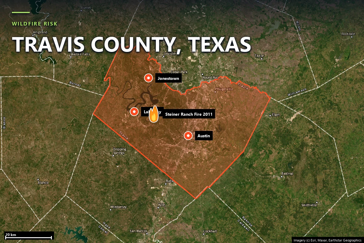
Travis County is where the Blackland Prairie meets the Edwards Plateau. Austin sits on the prairie side; the western third of the county climbs the Balcones Escarpment into limestone canyons covered in Ashe juniper and live oak, cut by the Colorado River and impounded into Lake Austin and Lake Travis. Almost all of the county's wildfire exposure lives in that western third — and so does a great deal of its most expensive housing.
On 4 September 2011, the same day and the same Tropical Storm Lee wind field that ignited the Bastrop County Complex sixty miles east, fire moved into the Steiner Ranch development west of Austin. By the numbers it was a small incident:
Seven hours, for 162 acres. That ratio — trivial fire, extraordinary evacuation time — is the whole Travis County story, and it is the thing a hazard map cannot show you. Steiner Ranch was widely described afterwards as having effectively one way out. A second emergency evacuation route was eventually built and opened, more than a decade later.
Sources: Texas A&M Forest Service · Travis County ESD / Lake Travis Fire Rescue reporting · contemporaneous Austin news coverage of the September 2011 fires.
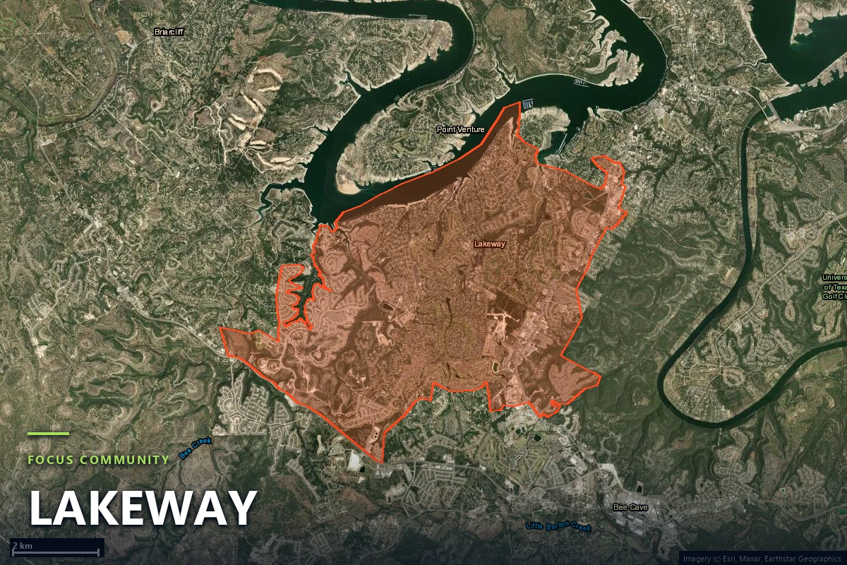
Because OpenStreetMap carries no boundary polygon for Steiner Ranch, our community-scale analysis uses Lakeway — the incorporated city about five kilometres west, in the same juniper belt on the same lake. Every community-scale figure on this page is Lakeway's; every parcel-level figure is the Steiner Ranch property's. Lakeway covers 3,919 hectares, gridded into 293 analysis zones.
The LANDFIRE vegetation layer describes the fuel precisely: 45.2% Edwards Plateau Limestone Savanna and Woodland — Ashe juniper and live oak over shallow soil on limestone — with 12.0% open water and roughly 21% developed land. Juniper, known locally as cedar, carries volatile oils and burns hot and fast once cured, which is why it dominates every Hill Country fire briefing. But it is also broken here: by the lake, by bare rock, and by subdivision. The Satelife area vegetation layer for Lakeway reads 25 / 100, and for the Steiner Ranch parcel 31 / 100.
The consequence shows up in the federal fire-behaviour model. At the Steiner Ranch parcel the USFS Wildfire Risk to Communities conditional flame-length raster returns 0.0% probability of flames over four feet. That is a genuinely low number and we are not going to dress it up: on current fuels, at this specific parcel, the model does not expect a fire that hand crews cannot engage. Terrain scores 40 / 100 on an elevation band of 163 m — a coarse proxy, since the layer has no slope raster at this location, so read it as "foothills" rather than as a canyon-by-canyon assessment.
This section is why the page exists. Satelife's road-access layer rebuilds suppression reach and egress from the current road graph rather than from distance-as-the-crow-flies, and at the Steiner Ranch parcel the two diverge violently:
Read that second tile twice. Bee Caves Road is 2.2 km away in a straight line and 28.8 km — a modelled 32 minutes — by road, because the direct line crosses water. Lake Travis Fire Rescue Station 603 sits 3.0 km from the parcel and models at 29.3 minutes. Lakeway Fire Station 602 is 6.0 km away and models at 26.0 minutes. The fastest modelled approach in the whole set, from an unnamed station 5.6 km out, is 9.4 minutes. Seventeen stations within fifteen kilometres, and the water between them and you turns nearly all of them into long drives.
That is what produces a road-access layer of 45 / 100 — the worst single layer in the Steiner Ranch report, and worse than the corresponding layer at either Tahitian Village or Fritch, which both score 10. It is also, quantitatively, the 2011 evacuation: seven hours is what happens when a peninsula full of houses empties through a network whose redundancy score is 1.
At community scale Lakeway looks healthier — 52 independent road exits across 293 zones, 5.6 zones per exit, a fastest modelled engine time of 2.8 minutes from Lakeway Fire Station 602 with five stations in range. But its hotspot zones still model at 11.4 to 11.9 minutes, and its network narrows to a 25.5-metre point. Better than Steiner Ranch; not comfortable.
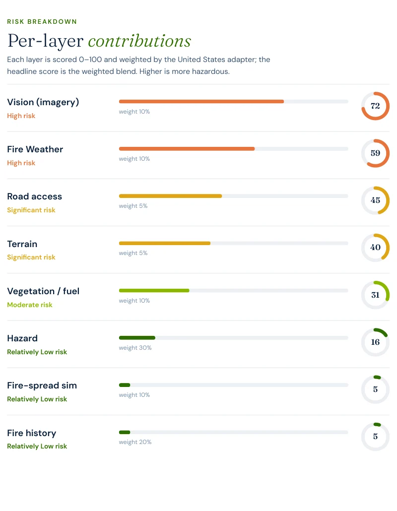
Travis County inverts the usual reading of a Satelife composite. In Hutchinson County the score is high because the fuel is loaded and the model says so. Here the score is 27 / 100 because three of the eight layers — hazard, fire history and fire-spread — read very low, and the one that reads worst is the one no zone map contains.
The fire-history layer deserves a caveat rather than a conclusion. It reads mapped NIFC and WFIGS perimeters, and it finds none at this parcel — but the 2011 Steiner Ranch fire, at 162 acres and under local jurisdiction, is not in the certified national perimeter set. A 5 / 100 fire-history score at this address means "no federally mapped perimeter here", not "this place has never burned". It has, within living memory, fatally.
We ran a full Satelife wildfire-risk report for a property on South Quinlan Park Road, Austin TX 78732 — the spine road of Steiner Ranch, inside the area that burned in 2011. The composite: 27 / 100 — Moderate tier, at 0.78 confidence, from eight independently-scored and weighted layers.
What drives the score:
The mitigation plan the report generates for this parcel is the standard pair — audit defensible space annually before fire season, and verify access-route width and gate clearance. In Steiner Ranch the second one is not boilerplate. It is the same 4.6-metre measurement, restated at the scale of a driveway.
The western Travis County interface — Steiner Ranch, Lakeway, Bee Cave, West Lake Hills, River Place — is some of the most expensive residential property in Texas, and none of it comes with a wildfire disclosure. Texas publishes no fire-hazard-severity zone map, so the Texas Property Code §5.008 Seller's Disclosure Notice has no wildfire designation to ask about, and Texas is a non-disclosure state for sale prices on top of that. A buyer doing wildfire diligence here is starting from nothing the state hands them.
Nor is there a mitigation-discount mandate: Texas has no equivalent of California's SB 1060, so premium credit for defensible space and home hardening is a carrier-by-carrier underwriting decision. The fallback if the admitted market declines you is the Texas FAIR Plan Association, the residential insurer of last resort administered under the Texas Department of Insurance, which requires denial by at least two carriers actively writing in Texas before you are eligible.
For a $1M-plus canyon-side property, the practical implication is that the diligence has to be bought rather than looked up. A parcel-level report that dates the vegetation, the structure and — in this county especially — the access geometry is the document that substitutes for the hazard map Texas does not print.
Sources: Texas Department of Insurance · Texas FAIR Plan Association · Texas Property Code §5.008.
The defensible-space zones still apply — Zone 0 in the first five feet, Zone 1 out to thirty, Zone 2 to a hundred — and in juniper the highest-value work is removing the ladder fuel and the ornamental shrubs sitting against the wall that the vision layer flagged at 72 / 100. But this county's distinctive lever is not vegetation. It is knowing your route before you need it: which of your neighbourhood's exits exist, which one is the 4.6-metre one, and what the staged evacuation plan for your section actually says. Austin–Travis County and the ESD fire departments publish those plans; the second Steiner Ranch evacuation route exists because residents pushed for a decade after 2011.
Set against our other Texas pages the contrast is clean. Steiner Ranch: composite 27 / 100, four-foot flame probability 0.0%, road access 45, 4.6-metre chokepoint. Tahitian Village, Bastrop County: 46 / 100, 28.1%, road access 10, one approach route, 30.7-metre chokepoint. Fritch, Hutchinson County: 59 / 100, 71.0%, road access 10, one fire station at 1.2 minutes. Fritch has the fuel problem, Bastrop has the reloading-fuel-plus-one-road problem, and Travis County has the cleanest fuel and the worst roads — with by far the most people behind them.
Satelife runs address-level wildfire reports across every ZIP code in Travis County. The ZIPs below are the Balcones Escarpment juniper and Wildland-Urban Interface communities we are asked about most. One caveat that is the whole point of what we do: the risk score is computed for your parcel, not the ZIP, so two homes on the same street can land in different tiers. Find your area, then run your address.
| ZIP code | Community | Why it is on the map |
|---|---|---|
| 78732 | Austin (Steiner Ranch) | Quinlan Park Road case study; 2011 fire, lake-bounded access |
| 78734 | Austin (Lakeway) | Community case study; Ashe juniper WUI on Lake Travis |
| 78738 | Austin (Bee Cave / Lakeway West) | Fast-growing interface along Highway 71 |
| 78645 | Leander (north Lake Travis) | Jonestown and the lake’s northern shore subdivisions |
| 78669 | Spicewood | West-county interface; 2011 Pedernales Bend fire area |
| 78733 | Austin (Bee Creek) | Barton Creek greenbelt canyons inside the city |
| 78746 | Austin (West Lake Hills) | Dense housing in steep juniper canyon terrain |
| 78730 | Austin (River Place) | Bull Creek canyon WUI north of the river |
| 78736 | Austin (Oak Hill) | Southwest interface where suburb meets juniper |
ZIP areas per USPS. Texas publishes no statewide fire hazard severity zone map; Wildland-Urban Interface framing per Texas A&M Forest Service.
The fuel is thinner than the Texas headline counties, and the exposure is far larger. A Satelife report for a Steiner Ranch address returns 27 / 100 in the Moderate tier, with the USFS model putting the probability of flame lengths over four feet at 0.0%. But the same report scores road access at 45 / 100 — its worst layer, and worse than either Bastrop or Hutchinson County — and detects a 4.6-metre single point of failure on the road network. In Travis County the binding constraint is not flame length. It is how many people are behind how few roads.
On 4 September 2011 — the same day and the same weather system that started the Bastrop County Complex — fire moved through the Steiner Ranch development west of Austin. It burned roughly 162 acres and destroyed 23 homes, with three more structurally damaged and 28 properties suffering exterior damage; more than 300 homes were saved by about 300 firefighters, and a Travis County deputy constable died after helping residents escape. The evacuation took as long as seven hours to complete.
Because of the road geometry. From the Steiner Ranch parcel we scored, the nearest highway is 2.2 km away in a straight line — and 28.8 km, or a modelled 32 minutes, by road. Seventeen fire stations sit within the 15 km search radius, yet the fastest modelled approach from a named station is 9.4 minutes and several are over 25 minutes. A 162-acre fire in that geometry is a bigger operational problem than a 2,000-acre fire on a grid.
Ashe juniper and live oak over limestone — the LANDFIRE layer classifies 45.2% of the Lakeway area as Edwards Plateau Limestone Savanna and Woodland. Juniper carries volatile oils and burns hot and fast when cured, which is why the local name for it, "cedar", turns up in every Hill Country fire briefing. The Satelife area vegetation layer for Lakeway reads 25 / 100 — real fuel, but discontinuous, broken up by lake, rock and development.
Yes, and it took over a decade. Steiner Ranch was widely described after 2011 as having effectively one way out; a second emergency evacuation route was subsequently built and opened. That is the correct category of fix for this county — the exposure here is answered with road capacity and staged evacuation planning far more than with fuel treatment.
If you own or are buying in western Travis County — Steiner Ranch, Lakeway, Bee Cave, West Lake Hills, River Place or Spicewood — get the address-level answer: PDF, per-layer score, and a prioritized mitigation plan.
Start with your address →