HomeWildfire RiskCaliforniaLos Angeles County
Los Angeles County, California · 2026

Wildfire risk in Los Angeles County: two megafires, seven years apart, closing in on the same coastline

The 2018 Woolsey Fire burned 96,949 acres and 1,643 structures across the western Santa Monica Mountains, forcing the evacuation of every resident of Malibu. Seven years later, the January 2025 Palisades Fire burned in from the east along the same range — one of the two fires that, together with Eaton, destroyed more than 18,000 structures across the county in a single week. A current Satelife property report for a Rambla Pacifico Street address in Las Flores Canyon, in the gap between the two burn scars, reads 51.1/100, High tier — and names the Palisades Fire directly.

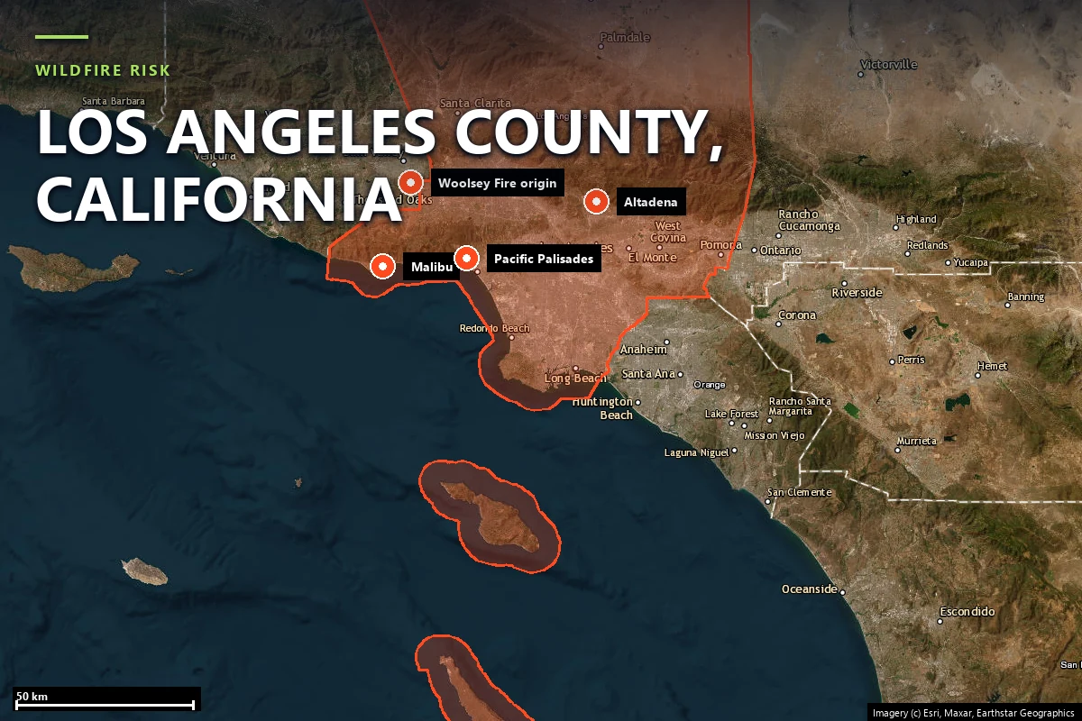
Satellite locator map headed “Wildfire risk — Los Angeles County, California”, with the county boundary outlined and Malibu, Pacific Palisades, Altadena and the 2018 Woolsey Fire ignition point marked
Los Angeles County on satellite imagery — county boundary with Malibu, Los Angeles, Altadena, Pacific Palisades, and the 2018 Woolsey Fire ignition point marked. Imagery © Esri, Maxar, Earthstar Geographics.
Local context

Two megafires that bracketed the same coastline

Los Angeles County runs from the Pacific coast at Malibu and Long Beach, up through the Santa Monica Mountains and the San Gabriel Valley, to the San Gabriel and Angeles National Forest crest above Altadena and La Cañada Flintridge. Its wildfire risk concentrates in two distinct WUI belts — the Santa Monica Mountains coastal range and the San Gabriel foothills — and both produced history-making fires within the same eighteen-month stretch:

The peak risk window runs roughly May through January — later than most of California, because the county's most destructive fires are driven less by summer drought than by autumn and winter offshore wind events: Santa Ana winds county-wide, and the Santa Monica Mountains' own local variant, sundowner winds, which reverse in the evening and drive fire downslope toward the coast at exactly the hour crews expect conditions to improve.

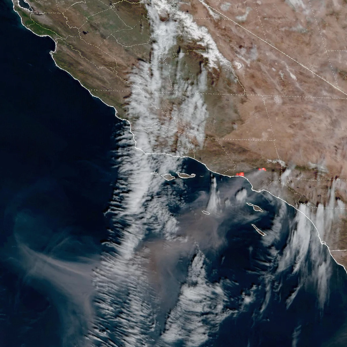
GOES-18 satellite image from January 8, 2025 showing the Palisades and Eaton fires burning simultaneously along the Southern California coast, with red fire-temperature hotspots and smoke streaming offshore
The Palisades and Eaton fires as seen by GOES-18, January 8, 2025 — two fires burning at once on opposite sides of Los Angeles County. Source: U.S. National Oceanic and Atmospheric Administration, via Wikimedia Commons (public domain).

Sources: CAL FIRE Incident Archive · NIFC · NOAA.

Terrain & vegetation

Canyon country that funnels straight to the Pacific Coast Highway

The Santa Monica Mountains run east-west between the San Fernando Valley and the coast, cut by steep north-south canyons — Topanga, Las Flores, Malibu, Corral, Zuma — that drain directly to Pacific Coast Highway. It is a textbook wind-and-terrain amplifier: canyons pre-heat fuels and channel offshore winds downslope, and every community in them has exactly one way out — down-canyon, onto PCH, the same road the fire is often burning toward.

Satelife's community-scale analysis of Las Flores Canyon — the Malibu neighborhood between the Woolsey and Palisades burn scars — scores the area-wide terrain layer at 40 / 100. The Rambla Pacifico Street case-study parcel itself scores lower, 20 / 100, because that specific address sits near the canyon mouth at roughly 13 metres elevation rather than up on the ridge — a reminder that a community-level score and a single parcel's score answer different questions. The vegetation immediately around that parcel reads as mostly urban and agricultural land cover rather than open chaparral, which is part of why its vegetation-layer score is a comparatively low 24.62/100 even inside a Very High hazard zone.

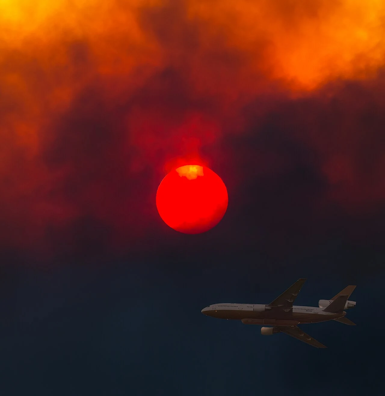
A DC-10 air tanker silhouetted below a deep red sun obscured by thick smoke during the 2018 Woolsey Fire in the Santa Monica Mountains
A DC-10 air tanker below a smoke-reddened sun during the Woolsey Fire, November 2018. Source: Peter Buschmann, USDA Forest Service, via Wikimedia Commons (public domain).
Evacuation

Twenty-two fire stations nearby. Sixteen ways out

Satelife's community-scale analysis of Las Flores Canyon builds the evacuation picture from the actual road graph and structure footprints — 469 structures across 1,807 hectares of canyon and ridge, gridded into 100-metre zones and scored at 55 / 100 — High area-wide.

469structures in the analyzed community area
16independent exit routes to the wider road network
~29structures per exit route
5.6 minmodelled fire-truck drive-time from the nearest mapped station (3.47 km)

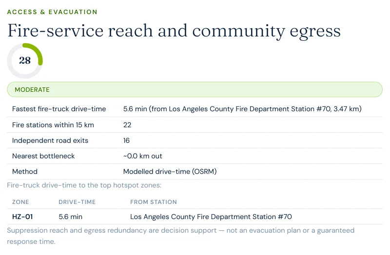
Fire-service reach here is genuinely strong — Los Angeles County Fire Department Station #70 sits 3.47 km away, a 5.6-minute modelled drive-time, and 22 stations are mapped within 15 km, dense urban coverage compared with the Sierra foothills. What the analysis flags instead is the same chokepoint geometry that trapped drivers on Pacific Coast Highway during both Woolsey and Palisades: the route graph found a single-point-of-failure segment of roughly 11 metres that multiple evacuation paths depend on. Sixteen exits across 469 structures is workable in isolation — but every one of those exits ultimately funnels onto the same coastal corridor the fire itself tends to be burning along.

Excerpt from a Satelife neighborhood wildfire report for Las Flores Canyon, Malibu: fire-service reach and community egress table showing 5.6-minute fastest fire-truck drive-time from LA County Fire Station #70, 22 stations within 15 km, and 16 independent road exits
Report excerpt — Access & Evacuation, Satelife Neighborhood Wildfire Risk Report for Las Flores Canyon, Malibu, CA (July 2026). Modelled OSRM drive-times from OSM-mapped stations. Decision support, not an evacuation plan.
The post-fire cycle

Two burn scars, two different clocks

Most California WUI communities have one post-fire story. Malibu has two running at once, on opposite sides of Las Flores Canyon. West of the canyon, the Woolsey scar is eight years old — vegetation has had most of a decade to regrow, and it is easy to mistake the current green hillsides for reduced risk. East of the canyon, the Palisades scar is barely eighteen months old as of this report; fuels there genuinely are cleared, for now.

Neither status has moved the one thing that matters most over the long run:

Chaparral is a fast fuel — a canyon that burned in 2018 can be flammable again well within a decade, and one that burned in 2025 will be flammable again well before this decade is out. A low vegetation reading anywhere in the Santa Monica Mountains is a snapshot, not a resolved risk.

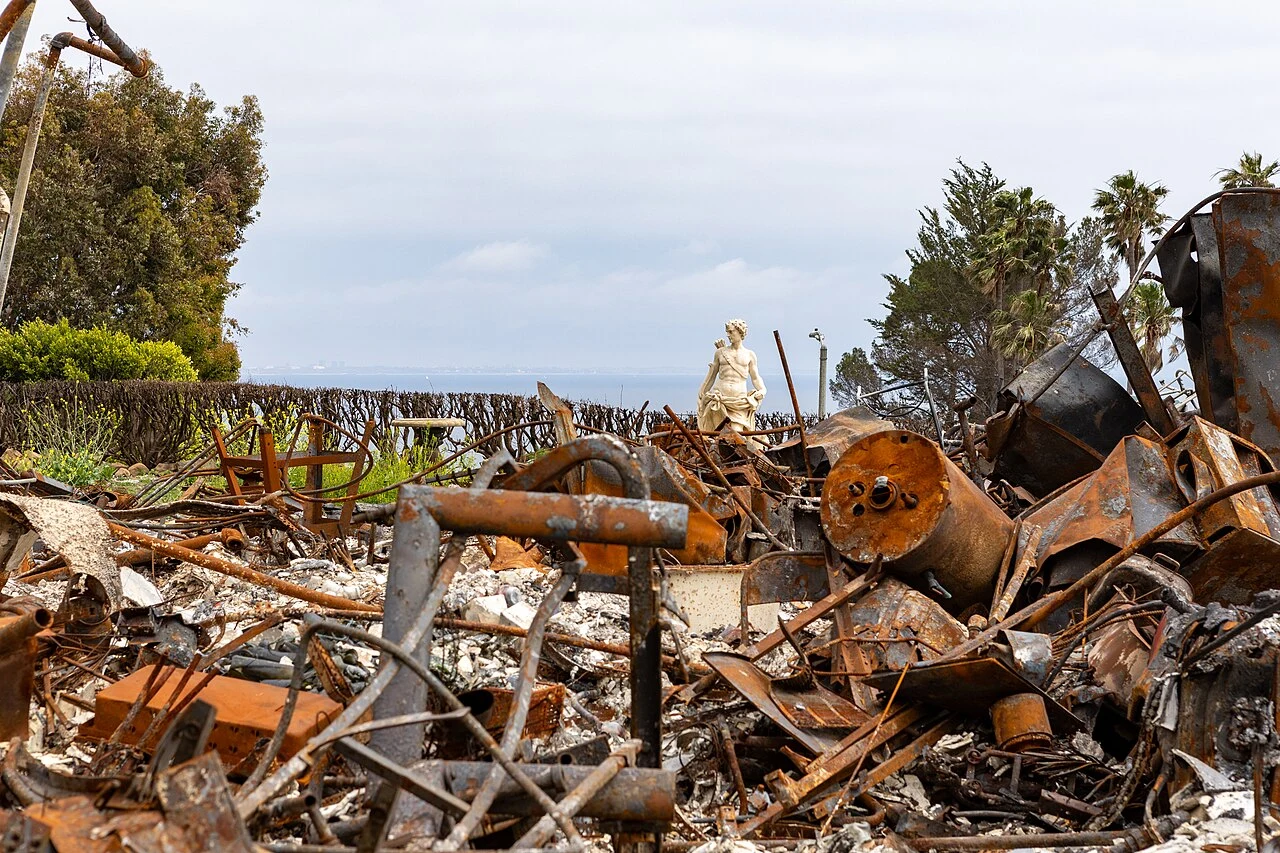
Wildfire-damaged Malibu home reduced to rusted debris with an intact garden statue overlooking the Pacific Ocean, awaiting Army Corps of Engineers debris removal after the January 2025 Palisades Fire
A fire-destroyed Malibu property awaits debris removal, May 2025 — Palisades Fire. Source: Christopher Rosario / U.S. Army, via Wikimedia Commons (public domain).
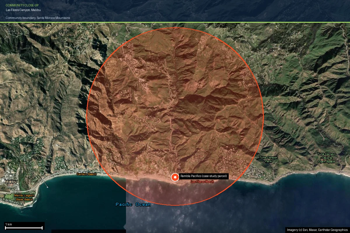
Las Flores Canyon community boundary outlined on current satellite imagery in the Santa Monica Mountains above Malibu, showing the canyon and ridge terrain between the Woolsey and Palisades fire footprints
The Las Flores Canyon analysis boundary on current satellite imagery — the canyon sits in the gap between the 2018 Woolsey and 2025 Palisades burn scars. Imagery © Esri, Maxar, Earthstar Geographics.
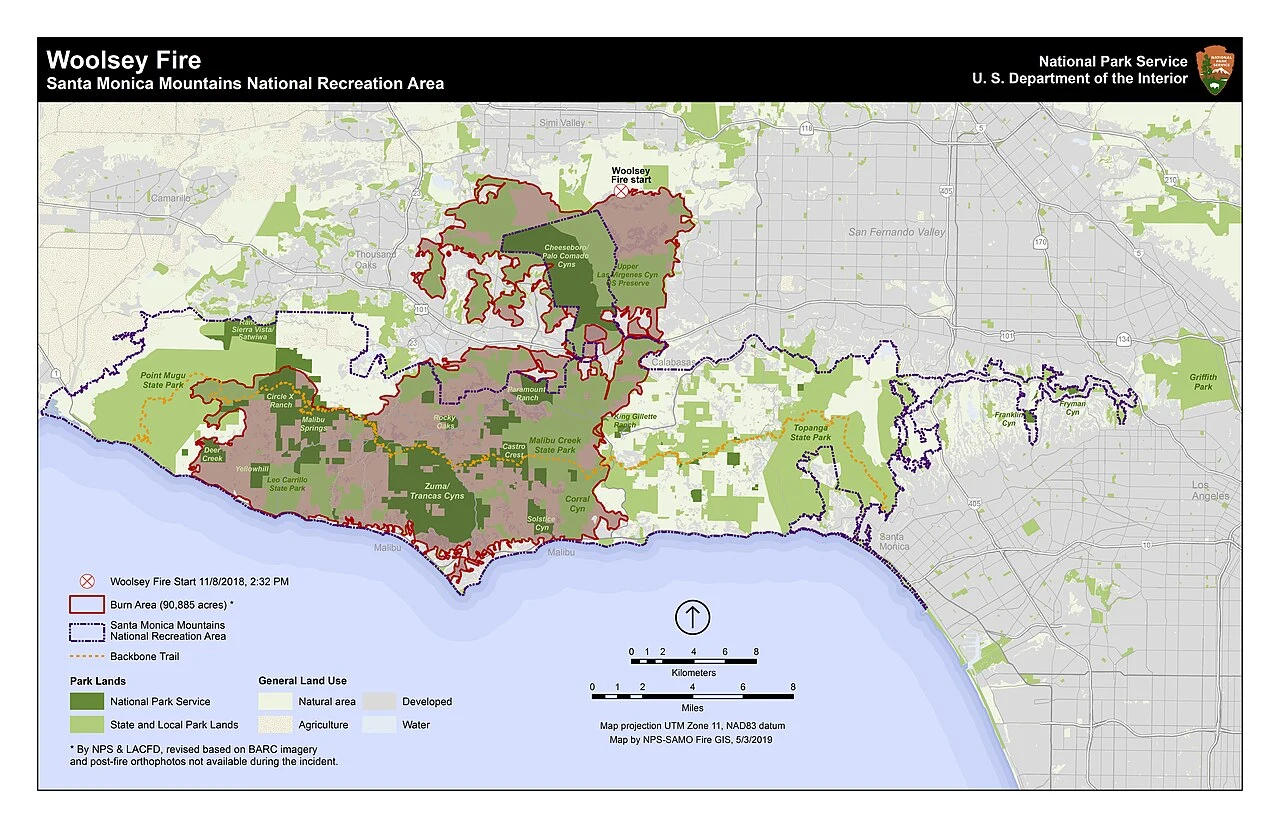
National Park Service map of the 2018 Woolsey Fire burn area across the Santa Monica Mountains National Recreation Area, showing the fire start point near Simi Valley and the burn perimeter reaching the coast at Malibu but stopping short of Topanga
The Woolsey Fire's mapped burn area (90,885 acres within the Santa Monica Mountains National Recreation Area) stops short of Topanga — which is why the fire does not appear in a fire-history layer run for Las Flores Canyon, further east, while the 2025 Palisades Fire does. Source: Santa Monica Mountains National Recreation Area, National Park Service, via Wikimedia Commons (public domain).
Case study

One address on Rambla Pacifico Street, scored today

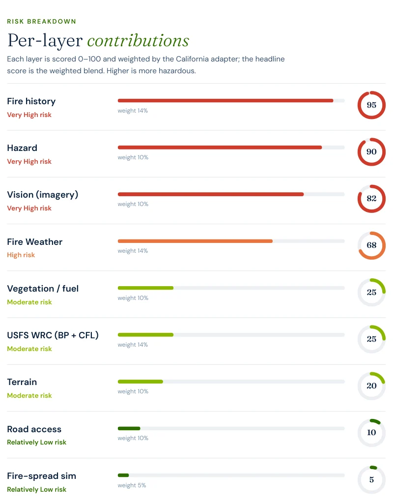
To make the county's risk concrete, we ran a full Satelife wildfire-risk report for a property on Rambla Pacifico Street, Las Flores, Malibu — in the canyon between the two burn scars. The composite score: 51.1 / 100 — High tier (82% confidence), built from ten independently-scored data layers rather than one hazard polygon.

Excerpt from a Satelife wildfire risk report for Rambla Pacifico Street, Malibu: per-layer contributions showing Fire history 95, Hazard 90, Vision 82, Fire weather 68, Vegetation 25, USFS WRC 25, Terrain 20, Road access 10, Fire-spread simulation 5
Report excerpt — Per-layer contributions, Satelife Wildfire Risk Report, Rambla Pacifico Street, Malibu, CA 90265 (July 2026). Composite 51.1/100, High tier.

What drives the score:

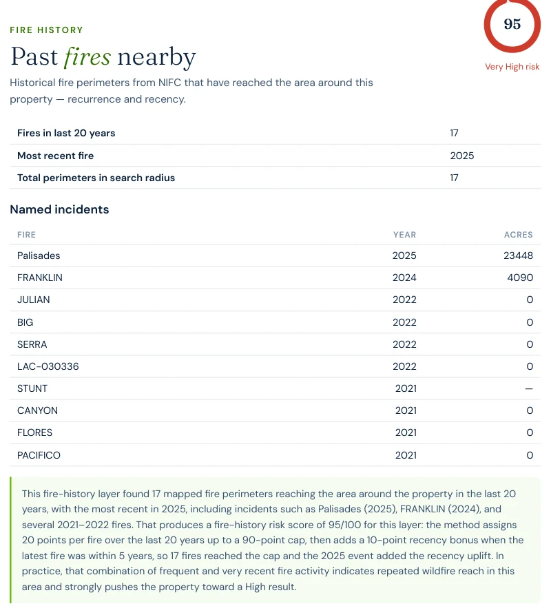
Excerpt from a Satelife wildfire risk report: fire history layer listing the Palisades Fire 2025 at 23,448 acres and the Franklin Fire 2024 at 4,090 acres, among 17 fires in the last 20 years and 17 total mapped perimeters
Report excerpt — Fire history: the layer names the Palisades Fire (2025) as the most recent and largest perimeter reaching this parcel.
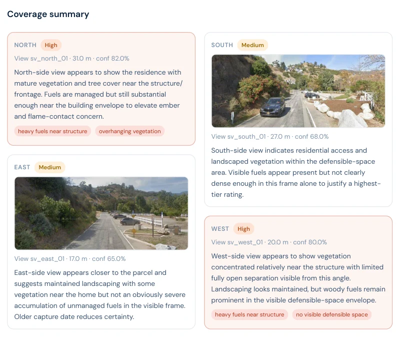
Excerpt from a Satelife wildfire risk report: street-view vision sweep showing north and west views rated High risk with heavy fuels near the structure and overhanging vegetation, and south and east views rated Medium
Report excerpt — Vision sweep by direction: the north and west views both rate High, with findings like "heavy fuels near structure" and "overhanging vegetation".
The FHSZ polygon says "Very High" for every parcel in this canyon equally. The report says this house has overhanging canopy on its north side and no open defensible space on its west side — and which three actions, in order, change that.

The report pairs the score with a prioritized mitigation plan for this exact parcel: establish an ember-resistant Zone 0 in the first five feet, harden the roof and screen vents against ember intrusion, and maintain thirty feet of lean, clean and green space. Under SB 1060-era rules, completing and documenting that work is not just safety advice — it is insurance evidence.

Insurance & real estate

The insurance squeeze in Los Angeles County

County homeowners feel all of the above through their insurance bill — when they can get one, and the January 2025 fires made that materially harder across the whole county, not just the burned neighborhoods. The pattern since has been accelerating carrier non-renewals followed by migration to the California FAIR Plan, the state's insurer of last resort, which surpassed 400,000 policies statewide in 2024 — roughly double its 2020 count, before the January 2025 fires even hit. FAIR Plan coverage is more expensive and thinner than the policies it replaces.

The regulatory response matters here: SB 1060 (in force 2025) requires carriers that use wildfire risk models to account for property- and community-level mitigation — defensible space, home hardening, community fuel breaks — rather than pricing on hazard zone alone. Together with the Safer from Wildfires framework, that creates a financial reason to prove, with evidence, what your specific parcel looks like. A zone map can't do that. An address-level report can.

For buyers and sellers, California Civil Code §1103 requires Natural Hazard Disclosure at the point of sale — and in the communities directly touched by the January 2025 fires, rebuild-and-resell transactions are already testing how that disclosure interacts with a freshly cleared parcel in a Very High zone. A buyer who cannot bind insurance cannot close. See California wildfire insurance and California real estate wildfire risk.

Sources: California Department of Insurance · California FAIR Plan · SB 1060 text.

Risk reduction

What Los Angeles County homeowners can actually do

CAL FIRE's defensible-space framework defines three zones: Zone 0 (0–5 ft, ember-resistant, no combustibles), Zone 1 (5–30 ft, lean-clean-green), and Zone 2 (30–100 ft, reduced fuel). Documented compliance is what underwriters and the SB 1060 discount process accept as evidence. Locally, the Malibu-Topanga Fire Safe Council coordinates fuel-reduction and evacuation-route work across the Santa Monica Mountains, while the Los Angeles County Fire Department runs local suppression response — the department a Satelife report for this canyon actually models drive-times from.

Annual review is the rule, not the exception: chaparral regrows fast, and in a canyon that has already produced 17 mapped fire perimeters in 20 years, a multi-year gap between inspections is not a safe assumption. A parcel that passed inspection in 2024 is not necessarily compliant in 2026.

El Dorado County and San Diego County each carry the scar of a single megafire event reaching their case-study community once or twice, at Sierra-foothill or backcountry suppression distances. Las Flores Canyon carries a different pattern: two different fires, seven years apart, arriving from opposite directions along the same mountain range — and a suppression response that is comparatively fast for California (5.6-minute drive-time from LA County Fire Station #70, versus 32 minutes to Grizzly Flats in El Dorado County) but a similarly narrow exit count: 16 independent road exits across 469 structures, roughly 29 per exit — close to San Diego Country Estates' 13-per-exit ratio, but funneled down canyon roads toward the same coastal highway the fire itself tends to be burning along.

A fast truck and a narrow canyon road are not opposites — they are two different numbers that both have to work at once. Los Angeles County's WUI communities generally get the first one right. The second one is geography, and geography does not move.
Coverage

ZIP codes we cover in Los Angeles County

Satelife runs address-level wildfire reports across every ZIP code in Los Angeles County. The ZIPs below are the high Fire Hazard Severity Zone, Wildland-Urban Interface communities we are asked about most. One caveat that is the whole point of what we do: the risk score is computed for your parcel, not the ZIP, so two homes on the same street can land in different tiers. Find your area, then run your address.

ZIP code Community Why it is on the map
90265 Malibu Woolsey (2018) and Palisades (2025) Fires; Rambla Pacifico case study
90290 Topanga Santa Monica Mountains canyon WUI with single-road egress
90272 Pacific Palisades 2025 Palisades Fire footprint
91302 Calabasas Woolsey Fire path, Santa Monica Mountains WUI
91301 Agoura Hills Woolsey Fire; chaparral WUI off the 101
91307 West Hills Western San Fernando Valley WUI edge, Woolsey exposure
91024 Sierra Madre San Gabriel foothills, Angeles National Forest interface
91011 La Canada Flintridge 2009 Station Fire front, foothill WUI

ZIP areas per USPS; Wildland-Urban Interface and Fire Hazard Severity Zone framing per CAL FIRE.

Where to go next

Los Angeles County wildfire risk in context

FAQ

Frequently asked questions about Los Angeles County wildfire risk

Is Los Angeles County a high wildfire risk area?

Yes, particularly the Santa Monica Mountains WUI communities — Malibu, Topanga, the Santa Monica Mountains canyons — and the San Gabriel foothill communities like Altadena. Both areas sit in CAL FIRE High or Very High Fire Hazard Severity Zones. The county absorbed two of the most destructive wildfires in California history within the same week: the January 2025 Palisades and Eaton fires destroyed more than 18,000 structures combined.

What was the largest wildfire in Los Angeles County?

By acreage entirely within the county, the 2009 Station Fire — 160,577 acres in the Angeles National Forest, an arson fire that killed two firefighters. By destructiveness, the January 2025 Palisades Fire (23,448 acres) and Eaton Fire together destroyed more than 18,000 structures, and the 2018 Woolsey Fire (96,949 acres, spanning Los Angeles and Ventura counties) forced the evacuation of every resident of Malibu.

Has Malibu burned before?

Repeatedly, and from different directions. The 2018 Woolsey Fire burned most of western and central Malibu and the Santa Monica Mountains to the north. The January 2025 Palisades Fire burned into eastern Malibu along the coast. A current Satelife fire-history layer for a Las Flores Canyon address in the gap between the two finds 17 mapped fire perimeters reaching the parcel in the last 20 years, headed by the Palisades Fire (2025).

How do I check the fire hazard zone for my Los Angeles County address?

Use the CAL FIRE FHSZ viewer for the official Moderate / High / Very High zone classification. For property-level detail — terrain, fuels, fire history, evacuation constraints, and an AI read of your actual parcel imagery — run a Satelife address-level report.

Can wildfire mitigation lower my insurance premium in Los Angeles County?

Yes. Under SB 1060 (in force 2025), California carriers that use wildfire risk models must account for property- and community-level mitigation. Documented defensible space and home hardening — the kind of evidence a Satelife report captures — feeds directly into that discount pathway, alongside the Safer from Wildfires framework. That pathway matters more here than almost anywhere in the state: Los Angeles County WUI communities saw a wave of non-renewals accelerate sharply after the January 2025 fires.

Scores and evacuation figures on this page are drawn from Satelife wildfire-risk reports for Malibu, CA generated in July 2026 (property report, Rambla Pacifico Street, Las Flores; neighborhood analysis, Las Flores Canyon, a 2.6 km radius community boundary). Satelife reports are informational decision support — not a substitute for official evacuation orders, CAL FIRE hazard determinations, or an insurer's underwriting judgement.

What does your parcel look like, layer by layer?

If you own, are buying, or are rebuilding in Los Angeles County — Malibu, Topanga, Altadena, or anywhere in the Santa Monica Mountains or San Gabriel foothill WUI — get the address-level answer: PDF, ten-layer score, and a prioritized mitigation plan.

Start with your address →