Wildfire risk in El Dorado County: the risk that doesn't reset after the fire
Three fires over 75,000 acres since 2014 — King, Caldor, Mosquito.
Communities on forested ridges between river canyons. An insurance
market in retreat. This page maps El Dorado County's structural
wildfire risk with satellite data and a real property-level report
from inside the Caldor burn scar.
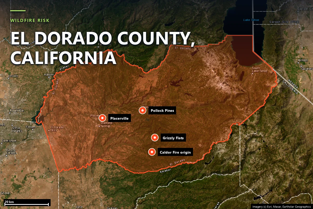
El Dorado County runs from the Sacramento Valley floor at El Dorado Hills up the western
slope of the Sierra Nevada to the shore of Lake Tahoe. Most of its population lives in the
middle elevations — Placerville, Camino, Pollock Pines, Georgetown, Grizzly Flats — exactly
the mixed-conifer belt where California's largest fires now burn. The recent record:
King Fire (2014) — 97,717 acres, ignited near Pollock Pines, an arson start that ran 15 miles up the Rubicon drainage in a single evening.
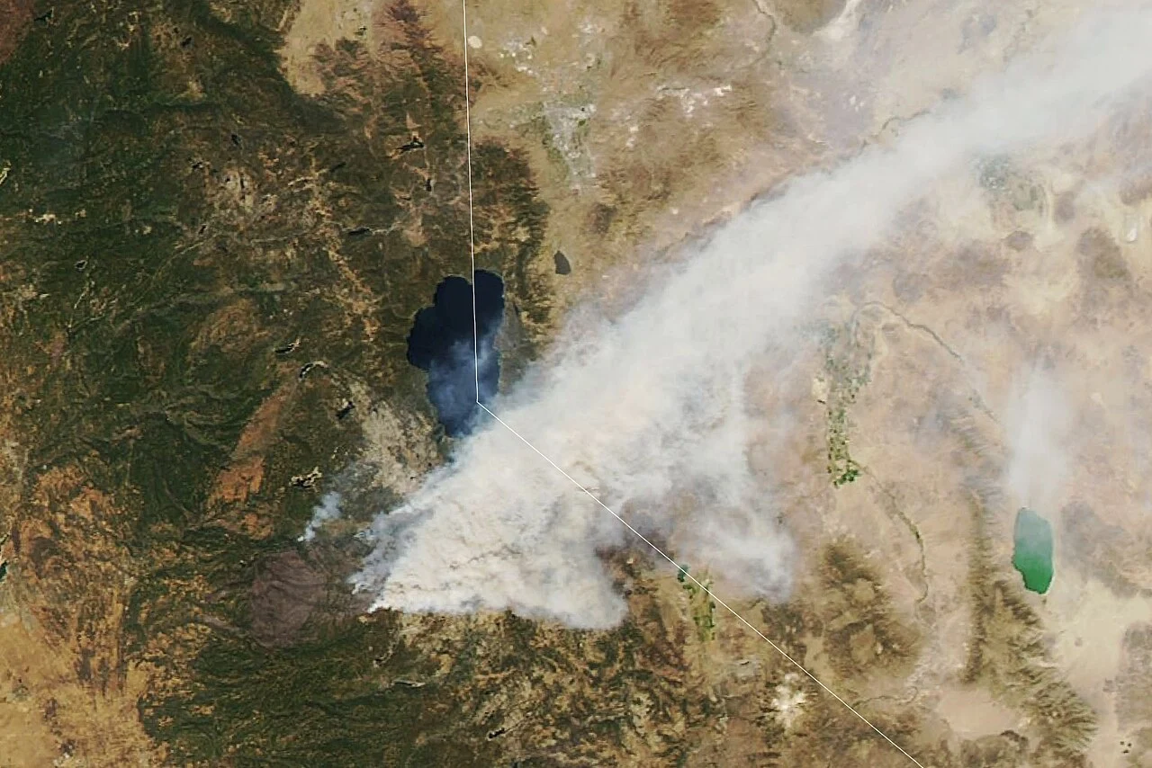
Caldor Fire (2021) — 221,835 acres, ignited in the Middle Fork Cosumnes drainage on August 14, destroyed most of Grizzly Flats, jumped Highway 50, crossed the Sierra crest, and forced the evacuation of South Lake Tahoe. More than 1,000 structures lost.
Mosquito Fire (2022) — 76,788 acres in the American River canyon on the Placer–El Dorado county line; California's largest fire of 2022.
The fire season runs June through October, with the most destructive events historically
falling in August and September, when fuel moisture bottoms out and terrain-driven wind
events align with the canyons.
The Caldor Fire's smoke plume from space, August 2021 — streaming across Lake Tahoe and into
Nevada. Source: NASA Earth Observatory / Lauren Dauphin, via
Wikimedia Commons
(public domain).
Sources: CAL FIRE Incident Archive · NIFC · NASA Earth Observatory.
Terrain & vegetation
Trap geography: communities on ridges between river canyons
Look at where the county's wildland-urban interface communities actually sit.
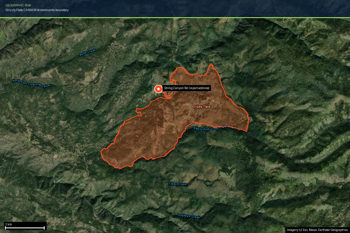
Grizzly Flats occupies a forested ridge between the forks of the Cosumnes
River. Pollock Pines sits on the divide above the South Fork American
River. Georgetown holds the divide between the Middle and South Forks of
the American. Ridge roads were where you could build — but it is precisely the layout fire
exploits.
Steep river canyons pre-heat fuels, channel wind, and accelerate flame fronts upslope. A
fire that starts at the bottom of a drainage arrives at the ridgetop community above it
with terrain-driven momentum. That is what the King Fire did in the Rubicon in 2014, and
what the Caldor Fire did to Grizzly Flats in 2021: ignition in the canyon below, a run
uphill into town. The terrain layer in Satelife's Grizzly Flats analysis scores
65 / 100 before a single tree is counted — slope and aspect alone put a
thumb on the scale.
The fuel is mixed conifer — ponderosa pine, Douglas-fir, incense cedar, white fir — with
oak woodland and brush at the lower elevations. Decades of fire suppression left dense,
ladder-fueled stands; post-fire landscapes regrow into brush and young plantations that
carry fire faster than the mature forest they replaced.
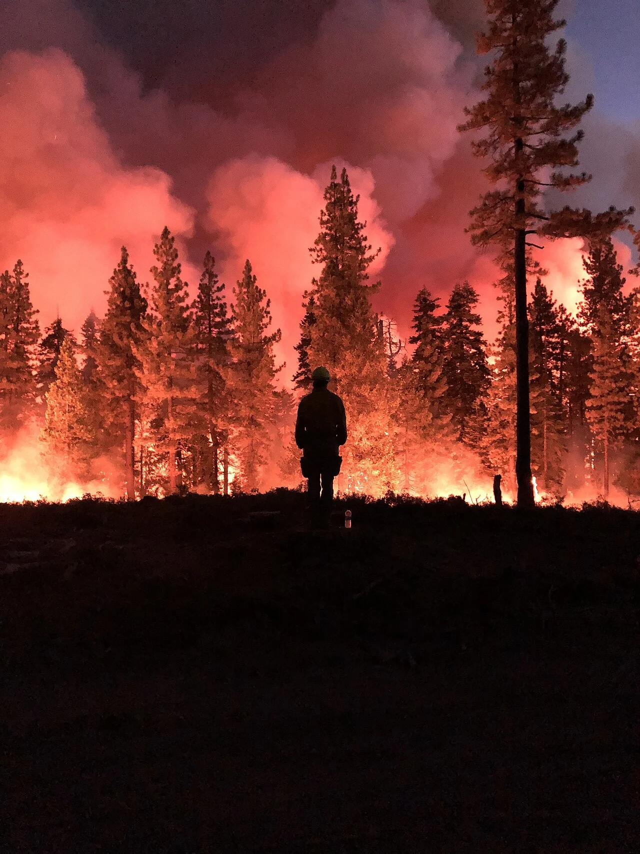
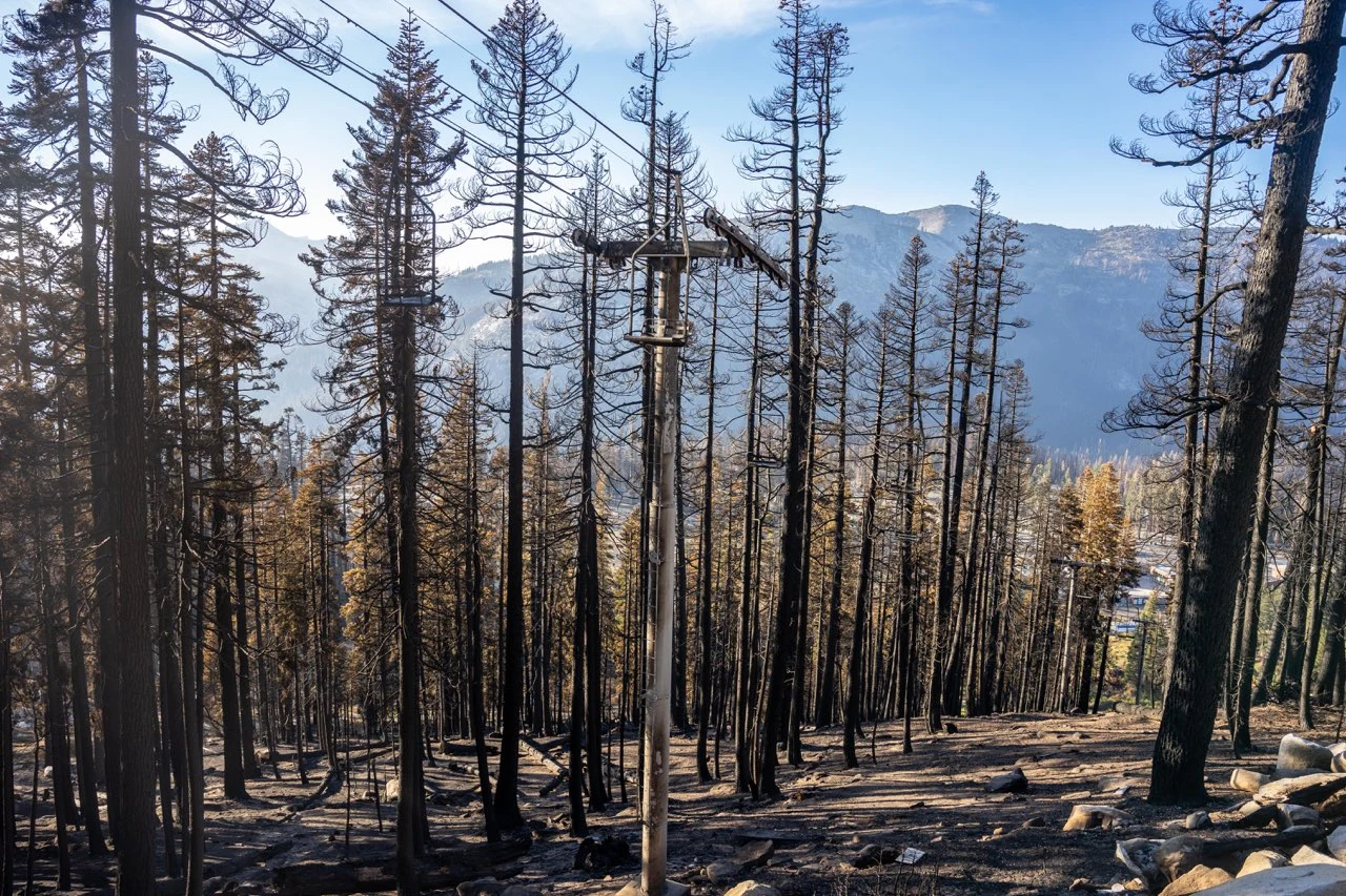
Burning operations on the Caldor Fire, 2021. Source: National Interagency Fire Center, via
Wikimedia Commons
(public domain).
Evacuation
Hazard maps say where fire is likely. They say nothing about whether you can leave
Satelife's community-scale analysis of Grizzly Flats builds the evacuation picture from the
actual road graph and structure footprints — 257 structures across 1,709 hectares, gridded
into 100-metre zones. The numbers:
257structures in the analyzed community area
9independent exit routes to the wider road network
~29structures per exit route
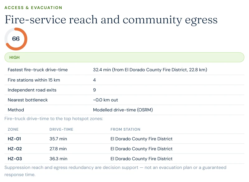
32 minmodelled fire-truck drive-time from the nearest full-time mapped station (22.8 km)
Nine exits sounds reassuring until you trace where they converge: the route analysis found a
single-point-of-failure segment of roughly 20 metres that multiple
evacuation paths depend on. If that one stretch is blocked — fire, a fallen tree, an
abandoned vehicle — the redundancy collapses. Modelled fire-truck drive-times to the
community's hotspot zones run 28 to 36 minutes. In 2021, residents
described escaping through flames on these same roads; the network being rebuilt today is
the same one.
Report excerpt — Access & Evacuation, Satelife Neighborhood Wildfire Risk
Report for Grizzly Flats, CA (July 2026). Modelled OSRM drive-times from OSM-mapped stations;
Grizzly Flats' own volunteer-staffed Pioneer FPD Station 35, reopened after the Caldor Fire,
is not yet mapped in OSM and would shorten local response. Decision support, not an
evacuation plan.
The post-fire cycle
The illusion of safety after a megafire
Here is the counterintuitive part: right now, some of Grizzly Flats' risk indicators look
good. The vegetation layer in Satelife's community analysis reads around
22 / 100 — because the forest that would carry the next fire mostly burned
in the last one. Standing among cleared lots and young regrowth in 2026, it is easy to
conclude the danger has passed.
It hasn't. It's cyclical. Three things did not burn away:
The hazard classification. CAL FIRE's Fire Hazard Severity Zone model scores long-term hazard from climate, terrain, and fire behavior over decades. Grizzly Flats remains Very High — 90/100 in the Satelife hazard layer, exactly as before the Caldor Fire.
The climate. The fire-weather signal that dried the Caldor's fuels scores 56/100 at this location and is trending the wrong way.
The topography. The canyons are permanent.
Meanwhile the fuel is coming back — post-fire Sierra landscapes regrow into brush and dense
young stands that carry fire faster than mature forest. The low vegetation score is a
temporary reprieve with an expiration date, and every home rebuilt during the reprieve will
spend most of its life inside the next fuel cycle.
To make the county's risk concrete, we ran a full Satelife wildfire-risk report for a
property on String Canyon Road, Grizzly Flats — inside the rebuilt
community, inside the burn scar, inside the Very High zone. The composite score:
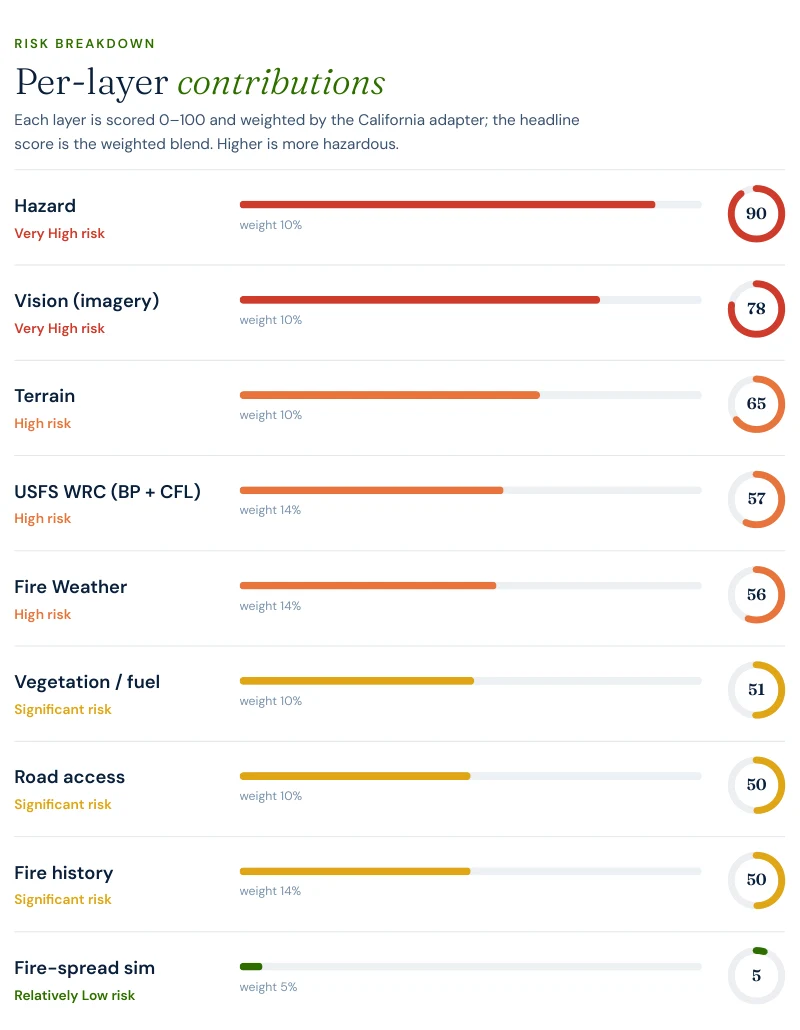
58 / 100 — High tier, built from ten independently-scored data layers
rather than one hazard polygon.
Hazard zone: 90/100. The parcel sits squarely in CAL FIRE's Very High Fire Hazard Severity Zone.
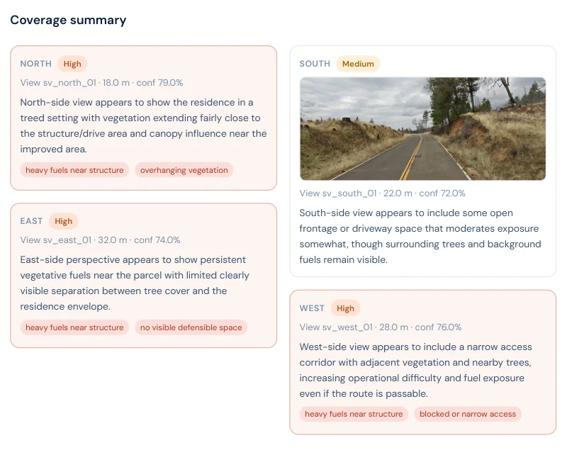
AI vision analysis: 78/100. The model reads aerial and street-level imagery of the actual property: mature trees close to the home, connected fuels inside the defensible-space envelope, limited maintained clearance, canopy over built areas, and receptive surface fuels beyond the improved margins.
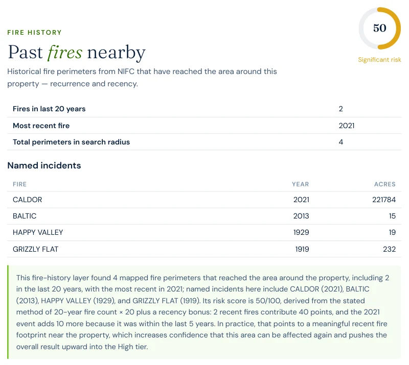
Fire history: 50/100 — and it names the Caldor. The layer finds 2 fires within 20 years, most recent 2021: CALDOR (221,784 acres) heads the incident list, alongside BALTIC (2013), HAPPY VALLEY (1929), and GRIZZLY FLAT (1919).
Fire behavior: USFS Wildfire Risk to Communities data puts the probability of flame lengths over four feet at this location at roughly 22% in a fire event.
Report excerpt — Fire history: the layer names the Caldor Fire (2021,
221,784 acres) as the most recent perimeter reaching this parcel.
Report excerpt — Vision sweep by direction: three of four aspects rate
High, with findings like "heavy fuels near structure" and "no visible defensible space".
The FHSZ polygon says "Very High" for every parcel in Grizzly Flats equally. The report says
this house has trees over the roofline and receptive fuels at the fence line — and
which three actions, in order, change that.
The report pairs the score with a prioritized mitigation plan for this exact parcel:
establish an ember-resistant Zone 0 in the first five feet, harden the roof and screen vents
against ember intrusion, and maintain thirty feet of lean, clean and green space. Under
SB 1060-era rules, completing and documenting that work is not just safety advice — it is
insurance evidence.
Insurance & real estate
The insurance squeeze in El Dorado County
County homeowners feel all of the above through their insurance bill — when they can get
one. Since 2021 the pattern across the county's WUI communities has been carrier
non-renewals followed by migration to the California FAIR Plan, the
state's insurer of last resort, which surpassed 400,000 policies statewide in 2024 —
roughly double its 2020 count. FAIR Plan coverage is more expensive and thinner than the
policies it replaces.
The regulatory response matters here: SB 1060 (in force 2025) requires
carriers that use wildfire risk models to account for property- and community-level
mitigation — defensible space, home hardening, community fuel breaks — rather than pricing
on hazard zone alone. Together with the Safer from Wildfires framework, that creates a
financial reason to prove, with evidence, what your specific parcel looks like. A zone map
can't do that. An address-level report can.
For buyers and sellers, California Civil Code §1103 requires Natural Hazard Disclosure at
the point of sale — and as insurance availability tightens, fire-zone status becomes a
closing-risk variable rather than a paperwork item. A buyer who cannot bind insurance
cannot close. See
California wildfire insurance
and
California real estate wildfire risk.
Sources: California Department of Insurance · California FAIR Plan · SB 1060 text.
Risk reduction
What El Dorado County homeowners can actually do
CAL FIRE's defensible-space framework defines three zones: Zone 0 (0–5 ft,
ember-resistant, no combustibles), Zone 1 (5–30 ft, lean-clean-green), and Zone 2
(30–100 ft, reduced fuel). Documented compliance is what underwriters and the SB 1060
discount process accept as evidence. Locally, the El Dorado County Fire Safe
Council coordinates community fuel-reduction projects and can advise on
neighborhood-scale work — the kind that shows up in the community-egress and hotspot
layers of a Satelife neighborhood report.
Annual review is the rule, not the exception: vegetation regrows, and in a post-fire
landscape like Grizzly Flats it regrows fast and flashy. A parcel that passed inspection
in 2024 is not necessarily compliant in 2026.
Coverage
ZIP codes we cover in El Dorado County
Satelife runs address-level wildfire reports across every ZIP code in El Dorado County.
The ZIPs below are the high Fire Hazard Severity Zone, Wildland-Urban Interface
communities we are asked about most. One caveat that is the whole point of what we
do: the risk score is computed for your parcel, not the ZIP, so two
homes on the same street can land in different tiers. Find your area, then
run your address.
ZIP code
Community
Why it is on the map
95636
Grizzly Flats
Caldor Fire (2021) razed the town; String Canyon Road case study
95726
Pollock Pines
Highway 50 forest WUI, on the Caldor Fire front
95709
Camino
Apple Hill forest WUI east of Placerville
95684
Somerset
Ridge WUI, Caldor Fire southern exposure
95667
Placerville
Foothill WUI at the county core
95634
Georgetown
Divide-country forest WUI, single ridge egress
95720
Kyburz
Highway 50 canyon, Caldor Fire burn
96150
South Lake Tahoe
Caldor Fire forced a full-basin evacuation in 2021
ZIP areas per USPS; Wildland-Urban Interface and Fire Hazard Severity Zone framing per CAL FIRE.
Frequently asked questions about El Dorado County wildfire risk
Is El Dorado County a high wildfire risk area?
Yes. Large parts of the county’s populated western slope — the Highway 50 corridor from Placerville through Camino and Pollock Pines, plus ridge communities like Grizzly Flats and Georgetown — sit in CAL FIRE High or Very High Fire Hazard Severity Zones. The county has recorded three 75,000+ acre fires since 2014 (King, Caldor, Mosquito).
What was the largest wildfire in El Dorado County?
The 2021 Caldor Fire — 221,835 acres. It ignited in the Middle Fork Cosumnes drainage on August 14, 2021, destroyed most of Grizzly Flats within days, jumped Highway 50, crossed the Sierra crest, and forced the evacuation of South Lake Tahoe before containment in October.
Is it safe to rebuild in Grizzly Flats after the Caldor Fire?
The hazard classification did not change: Grizzly Flats remains in a CAL FIRE Very High Fire Hazard Severity Zone, and a current Satelife hazard layer for a Grizzly Flats address still reads 90/100. Rebuilding is happening — the question is construction standard and defensible space. Homes rebuilt to Chapter 7A ember-resistant standards with documented mitigation face materially different exposure than the pre-2021 housing stock did.
How do I check the fire hazard zone for my El Dorado County address?
Use the CAL FIRE FHSZ viewer for the official Moderate / High / Very High zone classification. For property-level detail — terrain, fuels, fire history, evacuation constraints, and an AI read of your actual parcel imagery — run a Satelife address-level report.
Can wildfire mitigation lower my insurance premium in El Dorado County?
Yes. Under SB 1060 (in force 2025), California carriers that use wildfire risk models must account for property- and community-level mitigation. Documented defensible space and home hardening — the kind of evidence a Satelife report captures — feeds directly into that discount pathway, alongside the Safer from Wildfires framework.
Scores and evacuation figures on this page are drawn from Satelife wildfire-risk reports for
Grizzly Flats, CA generated in July 2026 (property report, String Canyon Road; neighborhood
analysis, Grizzly Flats CDP). Satelife reports are informational decision support — not a
substitute for official evacuation orders, CAL FIRE hazard determinations, or an insurer's
underwriting judgement.
What does your parcel look like, layer by layer?
If you own, are buying, or are rebuilding in El Dorado County — Grizzly Flats, Pollock Pines, Georgetown, Camino, or anywhere along the Highway 50 corridor — get the address-level answer: PDF, ten-layer score, and a prioritized mitigation plan.