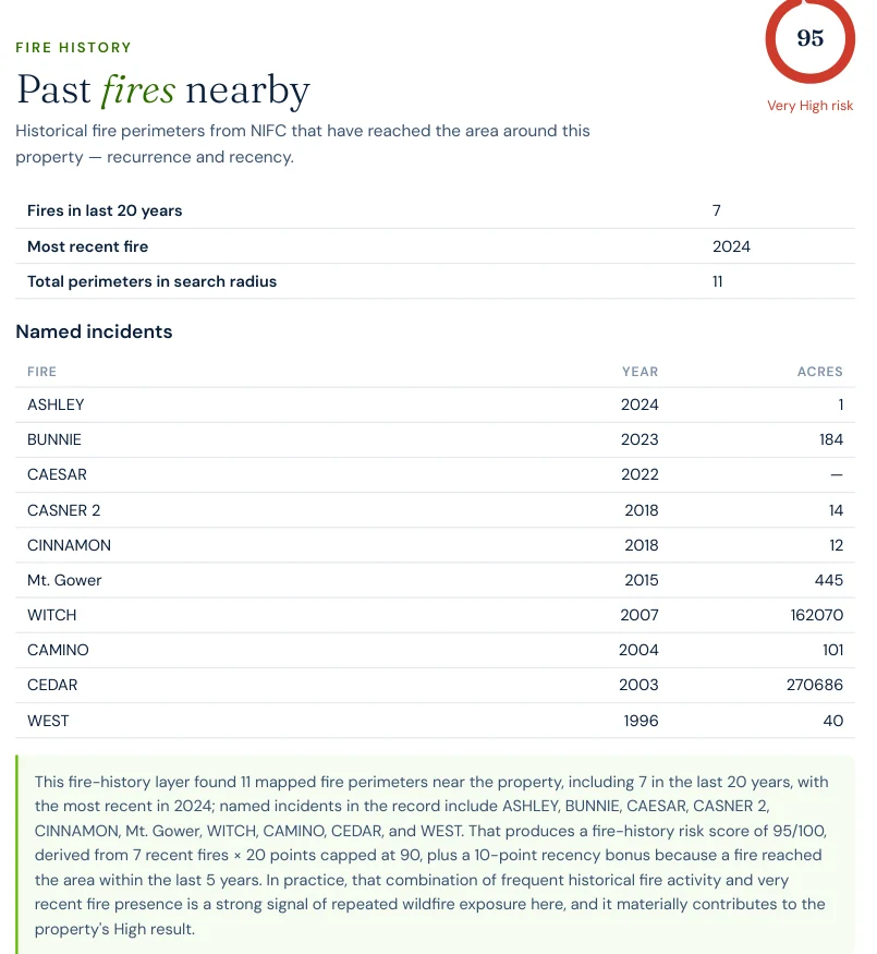
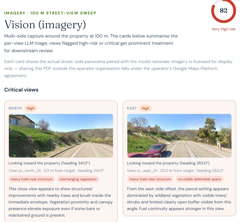
The 2003 Cedar Fire (273,246 acres, 2,232 homes lost) and the 2007 Witch Fire (197,990 acres, 1,265 homes lost) both reached San Diego Country Estates, inside Ramona — two of California's most destructive wildfires, four years apart. A current Satelife property report for a Vista Ramona Road address here reads 66.6/100, High tier. This page maps San Diego County's wildfire risk with satellite data and two real Satelife reports run from inside Ramona in July 2026.
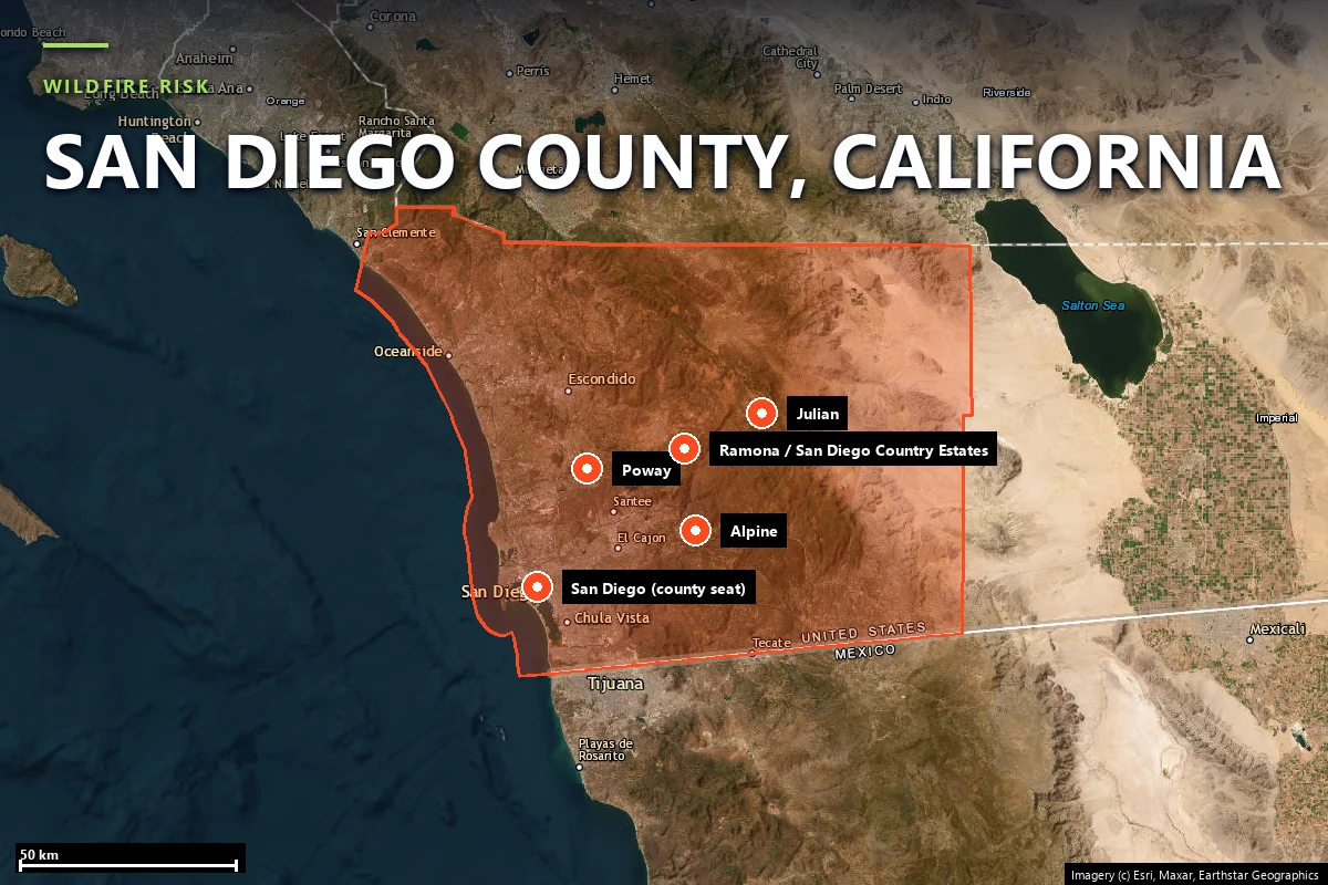
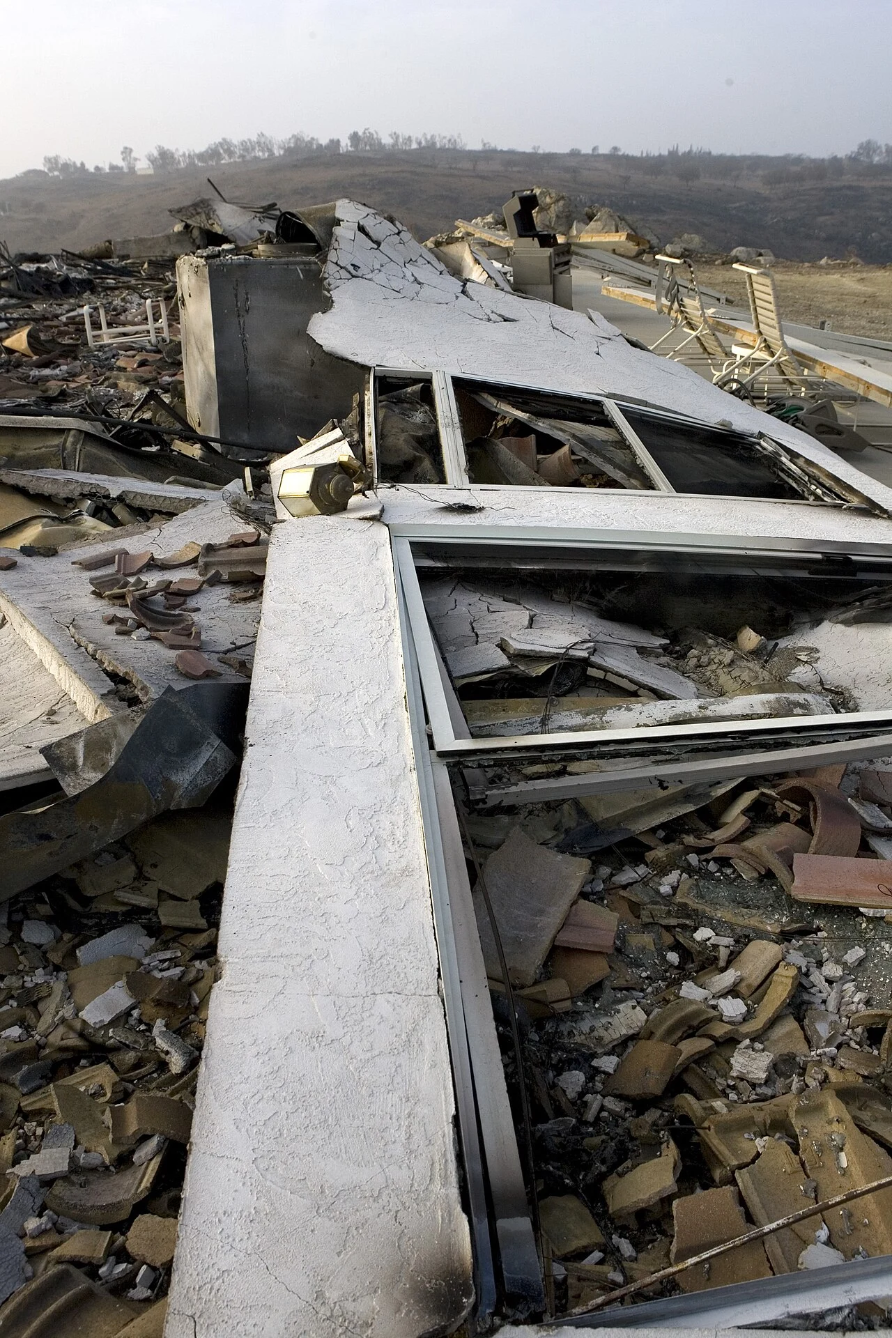
San Diego County runs from the coast at San Diego and Oceanside east through the foothill and mountain backcountry — Ramona, Alpine, Julian, Jamul, Potrero — to the desert edge near the Salton Sea. It is those backcountry WUI communities, not the coastal cities, that carry the county's structural wildfire risk. The record includes two of the largest wildfires in modern California history:
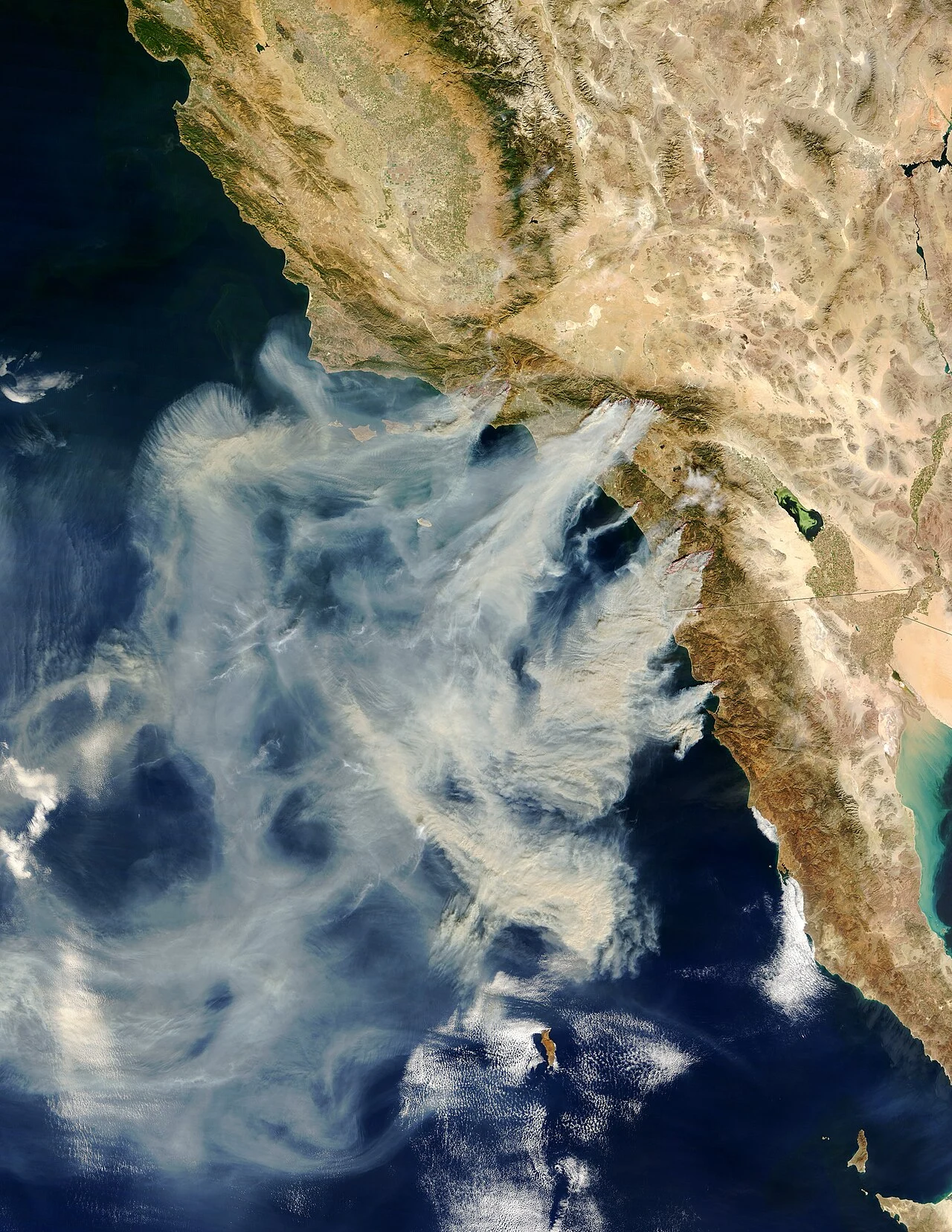
Unlike the Sierra foothill counties, where fire season peaks in summer, San Diego County's most destructive fires cluster in the Santa Ana wind season — typically September through December — when offshore winds push hot, dry air down through the canyons toward the coast at exactly the moment humidity bottoms out.
Sources: CAL FIRE Incident Archive · NIFC · San Diego County Office of Emergency Services.
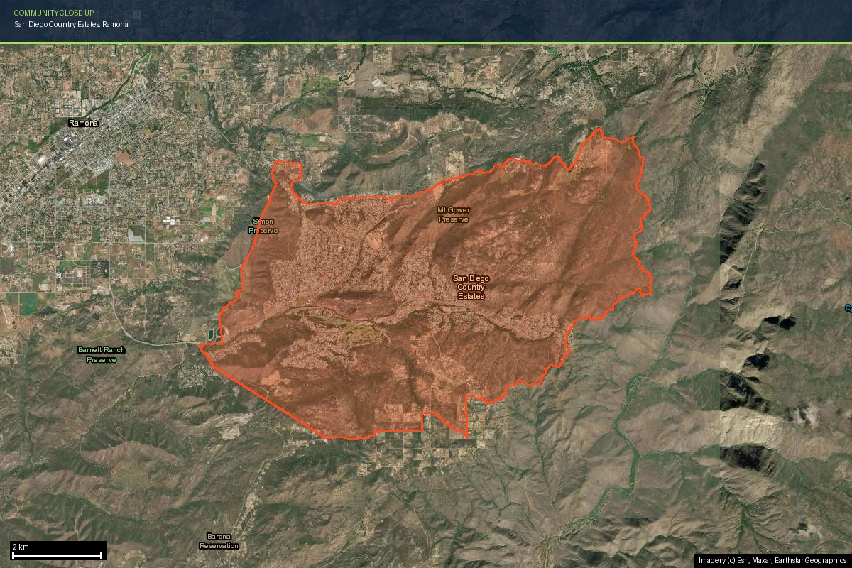
San Diego Country Estates sits in the San Vicente Valley just southeast of Ramona proper — roughly 6,000 acres of rolling hills studded with chaparral and coast live oak, developed as a master-planned golf-and-equestrian community mostly between 1970 and 1999. It is a textbook case of a Wildland-Urban Interface community built during a multi-decade lull between major fire events, on terrain that was never anything but flammable.
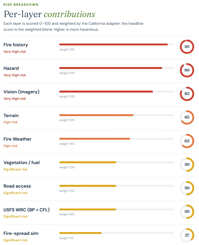
A Satelife property report for a Vista Ramona Road address scores the terrain layer at 65 / 100 — High risk: elevation banding and slope exposure that put real weight on the score before vegetation or structure condition are even considered. Santa Ana wind events compound the geography — offshore flow accelerates through the valley's canyon mouths, pre-heating fuel and pushing embers well ahead of the main fire front, which is exactly how the Witch Fire covered the roughly 15 miles from Witch Creek Canyon to San Diego Country Estates in under a day.
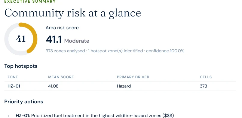
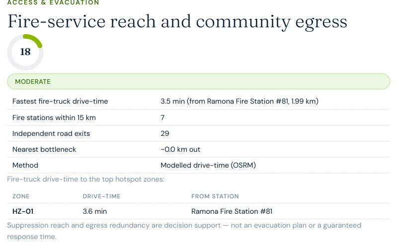
Satelife's community-scale analysis of San Diego Country Estates builds the evacuation picture from the actual road graph and structure footprints — 373 structures across 4,436 hectares, gridded into 100-metre zones and scored at 41 / 100 — Moderate area-wide.
Fire-service reach here is genuinely good — Ramona Fire Station #81 sits 1.99 km away, a 3.5-minute modelled drive-time, and seven stations are mapped within 15 km, one of them literally named Witch Creek Fire Station #87. What the analysis flags instead is redundancy: the route graph found a single-point-of-failure segment of roughly 21 metres that multiple evacuation paths depend on. Twenty-nine exits across 373 structures sounds workable in isolation, but it is exactly this kind of chokepoint geometry that turned the 2007 Witch Fire evacuation — more than 500,000 people across the county, the largest in San Diego County history — into a multi-hour gridlock on the roads leading out of Ramona.
San Diego Country Estates is a rare case where the "does low vegetation mean low risk" question has already been tested twice. The community's vegetation regrew after Cedar in 2003, then burned again in Witch in 2007 — and it has now had nineteen years to regrow a second time. Right now, Satelife's community-scale vegetation layer reads around 23 / 100, comparatively low.
That has not moved three things that matter more over the long run:
Chaparral regrows faster and burns hotter than the mixed-conifer forests of Northern California — a two-decade-old chaparral stand is already flammable. The low current vegetation score is not a resolved risk; it is a countdown.
To make the county's risk concrete, we ran a full Satelife wildfire-risk report for a property on Vista Ramona Road, San Diego Country Estates — inside the area both the Cedar and Witch fires reached. The composite score: 66.6 / 100 — High tier (78% confidence), built from ten independently-scored data layers rather than one hazard polygon.
What drives the score:
The report pairs the score with a prioritized mitigation plan for this exact parcel: establish an ember-resistant Zone 0 in the first five feet, harden the roof and screen vents against ember intrusion, and maintain thirty feet of lean, clean and green space. Under SB 1060-era rules, completing and documenting that work is not just safety advice — it is insurance evidence.
County homeowners feel all of the above through their insurance bill — when they can get one. Backcountry WUI communities have seen a steady pattern of carrier non-renewals followed by migration to the California FAIR Plan, the state's insurer of last resort, which surpassed 400,000 policies statewide in 2024 — roughly double its 2020 count. FAIR Plan coverage is more expensive and thinner than the policies it replaces.
The regulatory response matters here: SB 1060 (in force 2025) requires carriers that use wildfire risk models to account for property- and community-level mitigation — defensible space, home hardening, community fuel breaks — rather than pricing on hazard zone alone. Together with the Safer from Wildfires framework, that creates a financial reason to prove, with evidence, what your specific parcel looks like. A zone map can't do that. An address-level report can.
For buyers and sellers, California Civil Code §1103 requires Natural Hazard Disclosure at the point of sale — and as insurance availability tightens, fire-zone status becomes a closing-risk variable rather than a paperwork item. A buyer who cannot bind insurance cannot close. See California wildfire insurance and California real estate wildfire risk.
Sources: California Department of Insurance · California FAIR Plan · SB 1060 text.
CAL FIRE's defensible-space framework defines three zones: Zone 0 (0–5 ft, ember-resistant, no combustibles), Zone 1 (5–30 ft, lean-clean-green), and Zone 2 (30–100 ft, reduced fuel). Documented compliance is what underwriters and the SB 1060 discount process accept as evidence. Locally, the Fire Safe Council of Ramona West End maintains a Community Wildfire Protection Plan and coordinates fuel-break projects across the Ramona area, while the Ramona Municipal Water District Fire Department runs local suppression response — the station a Satelife report for this area actually models drive-times from.
Annual review is the rule, not the exception: chaparral regrows fast, and a two-decade fuel cycle in a Santa Ana wind corridor is not a long runway. A parcel that passed inspection in 2024 is not necessarily compliant in 2026.
It's worth naming how differently that risk is shaped 400 miles north, in El Dorado County's Sierra ridge communities. There, the constraint is suppression reach — a 32-minute modelled fire-truck drive-time to Grizzly Flats from the nearest full-time mapped station, 22.8 km away. Here, Ramona Fire Station #81 is 1.99 km from San Diego Country Estates and answers in 3.5 minutes. The constraint instead is capacity: whether 373 structures can clear a single 21-metre road segment before the fire the engine is racing toward gets there first — the same geometry that gridlocked 500,000 evacuees during the 2007 Witch Fire.
Satelife runs address-level wildfire reports across every ZIP code in San Diego County. The ZIPs below are the high Fire Hazard Severity Zone, Wildland-Urban Interface communities we are asked about most. One caveat that is the whole point of what we do: the risk score is computed for your parcel, not the ZIP, so two homes on the same street can land in different tiers. Find your area, then run your address.
| ZIP code | Community | Why it is on the map |
|---|---|---|
| 92065 | Ramona | Cedar (2003) and Witch (2007) Fires; Vista Ramona Road case study |
| 92036 | Julian | Cedar Fire; mountain forest WUI |
| 91901 | Alpine | Viejas and Cedar Fire corridor, Santa Ana exposure |
| 91935 | Jamul | Backcountry chaparral WUI, Harris Fire (2007) |
| 91916 | Descanso | Cuyamaca forest edge, Cedar Fire burn |
| 92082 | Valley Center | Paradise and Witch Fire path, North County WUI |
| 92028 | Fallbrook | Rice Fire (2007); avocado-belt WUI |
| 92040 | Lakeside | Cedar Fire (2003) ignition-to-suburb corridor |
ZIP areas per USPS; Wildland-Urban Interface and Fire Hazard Severity Zone framing per CAL FIRE.
Yes, particularly the backcountry and foothill communities east of I-15 — Ramona, Alpine, Julian, Jamul, Potrero. These areas sit in CAL FIRE High or Very High Fire Hazard Severity Zones and take the brunt of the Santa Ana wind events each fall. The county recorded two of California's most destructive wildfires within a four-year span: the 2003 Cedar Fire (273,246 acres) and the 2007 Witch Fire (197,990 acres).
The 2003 Cedar Fire — 273,246 acres, 2,820 structures destroyed (2,232 of them homes), 15 fatalities. It ignited south of Ramona on October 25, 2003 and, driven by Santa Ana winds, spread at rates up to 3,600 acres per hour. It remains one of the most destructive wildfires in California history.
Yes — twice within four years. The 2003 Cedar Fire and the 2007 Witch Fire (which ignited near Witch Creek Canyon and was driven west by Santa Ana winds) both reached San Diego Country Estates and the surrounding Ramona area. A current Satelife hazard layer for a San Diego Country Estates address still reads 90/100, and the fire-history layer names both incidents directly.
Use the CAL FIRE FHSZ viewer for the official Moderate / High / Very High zone classification. For property-level detail — terrain, fuels, fire history, evacuation constraints, and an AI read of your actual parcel imagery — run a Satelife address-level report.
Yes. Under SB 1060 (in force 2025), California carriers that use wildfire risk models must account for property- and community-level mitigation. Documented defensible space and home hardening — the kind of evidence a Satelife report captures — feeds directly into that discount pathway, alongside the Safer from Wildfires framework.
If you own, are buying, or are rebuilding in San Diego County — Ramona, San Diego Country Estates, Alpine, Julian, or anywhere in the backcountry WUI — get the address-level answer: PDF, ten-layer score, and a prioritized mitigation plan.
Start with your address →