Wildfire risk in Bastrop County: the subdivision where the fire started
The 2011 Bastrop County Complex destroyed 1,696 structures, killed two
people and burned for 55 days — still the costliest and most destructive
wildfire in Texas history. One of its three ignition points was Tahitian
Village. We ran a Satelife report for an address on Tahitian Drive: 46 / 100
composite, a fire-history layer at 95 / 100, and exactly
one independent approach route to the parcel.
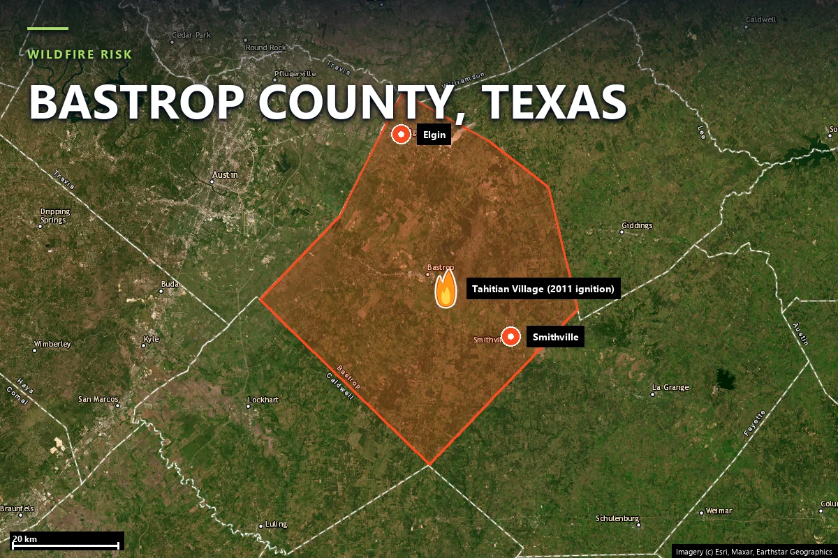
Bastrop County sits thirty miles east of Austin, on the Colorado River, and holds something
no other part of Texas has: the Lost Pines — an isolated island of loblolly
pine roughly a hundred miles west of the main East Texas pine belt, a relic stand growing on
deep sand that holds enough moisture to keep it alive. It is beautiful, it is why people move
here, and it is a closed-canopy conifer forest with houses inside it.
On 4 September 2011, at the end of the driest year in Texas record, Tropical
Storm Lee pulled hard northerly winds across Central Texas. Trees went into Bluebonnet
Electric Cooperative distribution lines at three separate places — along Schwantz Ranch Road
west of Texas 21, in Circle D Ranch, and in Tahitian Village — and the three
fires merged into the Bastrop County Complex.
1,696 structures destroyed, the great majority of them homes.
Two fatalities.
Roughly 34,000 acres burned, over 55 days.
About $350 million in insured property damage — the costliest wildfire in Texas history.
96% of Bastrop State Park — a 6,565-acre National Historic Landmark built by the Civilian Conservation Corps — burned.
The county has not been left alone since. The Hidden Pines Fire (October 2015)
burned more than 4,500 acres near Smithville, started by a spark from a mower on dry grass and
running for nearly two weeks. The Rolling Pines Fire (18 January 2022) began
as a 150-acre prescribed burn inside Bastrop State Park, escaped, and forced evacuations; the
mapped perimeter that Satelife's fire-history layer reads records 1,049 acres.
Two of the three most significant fires of the last fifteen years started with an ignition
source nobody would have called exotic: a power line, a mower, a planned burn.
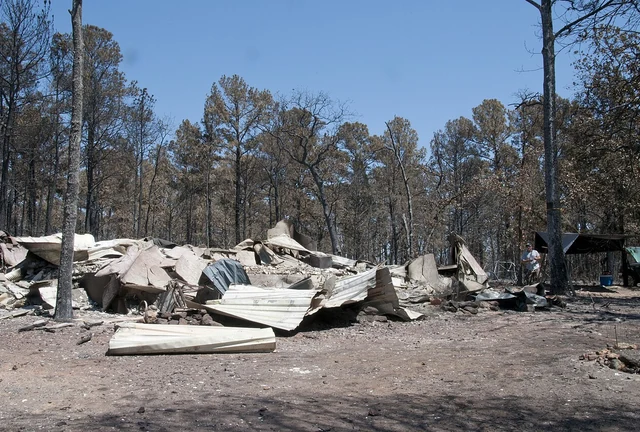
Bastrop County, 13 September 2011 — a resident looks at what is left of his home. Source:
Patsy Lynch/FEMA, via
Wikimedia Commons
(public domain).
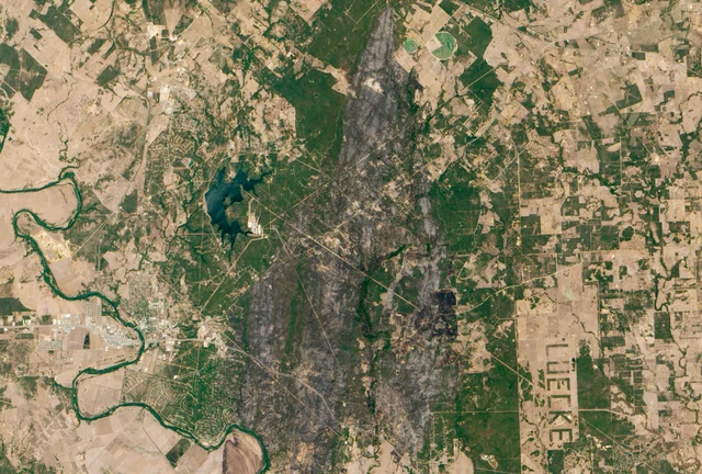
The burn scar on 12 September 2011 — the Lost Pines, seen from orbit. Source: NASA Earth
Observatory (Jesse Allen, Robert Simmon, EO-1 team), via
Wikimedia Commons
(public domain).
Sources: Texas A&M Forest Service fire investigation · Texas Parks & Wildlife Department ·
NIFC / WFIGS fire perimeters (via the Satelife fire-history layer).
Terrain & fuel
A pine forest with streets cut into it
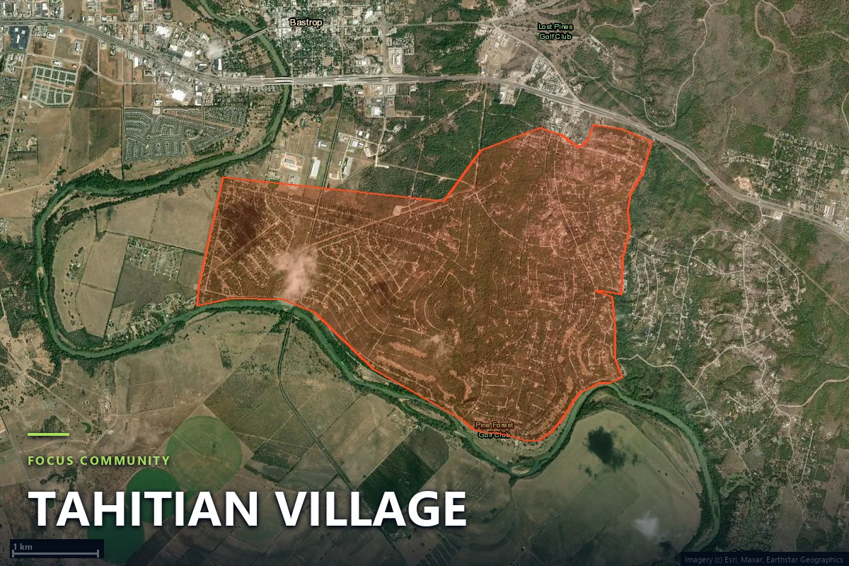
Tahitian Village is a 1,150-hectare subdivision on the bluffs south of the
Colorado River, platted in the 1970s across the Lost Pines and never fully built out. Satelife's
community-scale analysis grids it into 357 zones. On satellite imagery the
pattern is unmistakable: a dense curl of residential streets threaded through timber, with
built and unbuilt lots interleaved, so that a house frequently has standing forest on two or
three sides rather than a neighbour.
That structure is what the report's layers pick up separately. The
AI vision read of the parcel scores 76 / 100 — the second-highest layer in the
report — flagging mature trees on or immediately bordering the property, including trees near
the front and side approach, over maintained groundcover that stops short of a full
defensible-space envelope. Terrain reads 40 / 100 on the bluff-and-drainage
relief above the river; the thirty-year ERA5 fire-weather climatology reads
59 / 100.
The layer that reads low is the interesting one. Vegetation/fuel scores
27 / 100, because the LANDFIRE fuel-class mix within 100 m of this parcel is
dominated by urban and barren classes rather than timber — a direct consequence of the 2011
burn and the fifteen years of regrowth since. Fifteen-year-old loblolly is not the fuel bed
that burned in 2011. It is also not nothing, and it is getting older every season.
Evacuation
One road in, and a thirty-metre chokepoint
This is the measurement that zone maps cannot make. Satelife rebuilds the access picture from
the current road graph and OSM-mapped fire stations, at both parcel and community scale. At the
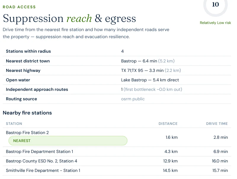
parcel, the road-access layer for Tahitian Drive returns
one independent approach route, with the first bottleneck effectively at the
property line. At community scale the 1,150-hectare boundary does better — but not cleanly:
24independent road exits from the analyzed Tahitian Village area
14.9analysis zones per exit route (357 zones / 24 exits)
30.7 mnarrowest single-point failure detected on the modelled network
5.5 minmodelled fire-truck drive-time from Bastrop Fire Station 2
Read those together. Twenty-four exits sounds like resilience until you note that the
community's risk concentrates into hotspot zones the model can reach in
2.0 to 7.6 minutes, and that the whole network narrows to a single
30.7-metre point. A chokepoint that width is a road that stops working the
moment one vehicle fails on it, or the moment fire runs the vegetation on both shoulders.
Suppression reach itself is genuinely good: four stations within the search radius, the nearest
1.6 km away.
Report excerpt — Road access: suppression reach & egress, Satelife
Wildfire Risk Report, Tahitian Drive, Bastrop TX 78602 (July 2026). Drive-times are modelled
on the public OSRM road graph and OSM-mapped stations; volunteer stations are frequently
untagged in OSM and would shorten local response. Decision support, not an evacuation plan
or a guaranteed response time.
Fire behaviour
What a rebuilt burn scar scores
Bastrop County is the clearest Texas example of a pattern the composite score cannot express on
its own: a place whose history is extreme and whose current fuel bed is not.
The report's fire-history layer for this parcel returns 95 / 100 — the highest
layer in the whole report, driven by recurrence. The USFS Wildfire Risk to Communities model,
which reads the fuel that is standing there now, puts the probability of flame lengths
exceeding four feet at 28.1%, and above eight feet at 0.0%.
95fire-history layer — recurrence, the report's highest
28.1%modelled probability of flame lengths over 4 ft
27vegetation / fuel layer — regrowth, not mature timber
24hazard layer — backfilled from USFS WRC; Texas has no FHSZ map
Four feet is the operational threshold at which hand crews stop being able to attack a fire
directly. A 28% chance of crossing it, on a parcel where the mature pine has not yet returned,
is the model saying this is the quiet part of the cycle. The Lost Pines are a fire-adapted
system; they came back after 2011 because that is what they do. The fuel load returns with them.
The 2011 fire did not make Tahitian Village safer. It reset a clock. Every season since has been
the fuel bed rebuilding toward the condition it was in on 3 September 2011 — and the houses
went back first.
Case study
One address on Tahitian Drive, scored today
We ran a full Satelife wildfire-risk report for a property on Tahitian Drive,
Bastrop TX 78602 — inside the subdivision where one of the 2011 ignitions occurred,
inside the regrown Lost Pines. The composite: 46 / 100 — Moderate tier, at
0.86 confidence, from eight independently-scored and weighted layers.
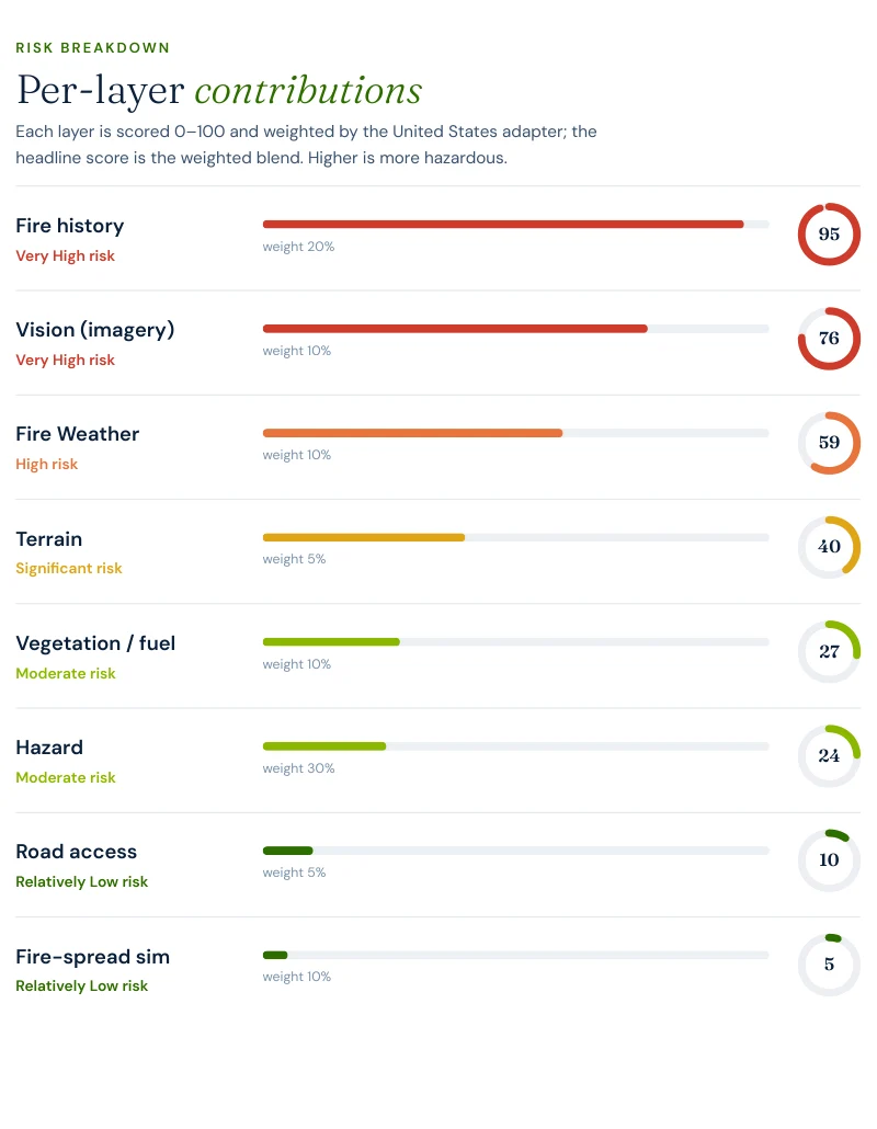
Report excerpt — Per-layer contributions, Satelife Wildfire Risk Report,
Tahitian Drive, Bastrop TX 78602 (July 2026). Composite 46/100, Moderate tier, scored under
the United States (usa_generic) adapter.
What drives the score:
Fire history: 95/100, weight 20%. The heaviest contributor. The mapped-perimeter sample for this parcel returns six incidents, most recent 2026, including the 1,049-acre Rolling Pines perimeter of January 2022.
AI vision analysis: 76/100. The model reads the parcel's own street-level and overhead imagery and finds mature trees on or immediately bordering the lot, including near the drive approach, over maintained lawn — separation that exists but does not close the defensible-space envelope.
Fire weather: 59/100. Thirty-year ERA5 climatology of the Canadian Fire Weather Index at this location.
Hazard: 24/100, weight 30% — the largest weight in the report. Not a Texas hazard rating, because Texas does not publish one: the layer is backfilled from the USFS Wildfire Risk to Communities model. It is the single biggest reason the composite reads Moderate rather than High.
Road access: 10/100. Strong suppression reach — one approach route, but a station 1.6 km away.
A parcel in the subdivision that ignited the most destructive fire in Texas history scores
46 / 100 — because thirty percent of the composite is a hazard-zone layer that Texas has no map
to fill. The per-layer breakdown is not a footnote to the score here. It is the answer.
The report pairs the score with a prioritized plan for this parcel: audit defensible space
annually before fire season, and verify access-route width and gate clearance. The second one
carries unusual weight in Tahitian Village — it is the same 30.7-metre geometry the community
analysis found, restated at the scale of one driveway.
Insurance & real estate
Texas gives you less paperwork, not less risk
A Bastrop County homeowner faces a different regulatory landscape from a Californian one, and
almost every difference cuts against the buyer. There is no Fire Hazard Severity Zone map to
look your address up on. There is no statutory wildfire-mitigation discount comparable to
California's SB 1060. The Texas Property Code §5.008 Seller's Disclosure Notice does not ask
the seller to disclose a wildfire hazard designation, because there is no designation to
disclose — and Texas is a non-disclosure state for sale prices on top of that.
What does exist is the Texas FAIR Plan Association — the residential insurer
of last resort, created by the legislature in 1995 and writing policies since 2002, and
administered under the Texas Department of Insurance. You become eligible only after being
declined by at least two carriers actively writing residential property insurance in Texas,
and you are ineligible if you hold or have been offered comparable coverage. It writes fire,
lightning, smoke, explosion, windstorm and hail among other perils, and like every
last-resort mechanism it is narrower and dearer than the admitted market it replaces.
That structure puts the burden of proof on the property owner. Where a Californian can point
an underwriter at a regulation, a Texan has to point at evidence. A dated, parcel-level record
of what the vegetation, the structure and the access actually look like is the practical
substitute — and the thing most likely to keep a Lost Pines address in the admitted market.
Sources: Texas Department of Insurance · Texas FAIR Plan Association · Texas Property Code §5.008.
Risk reduction
What Bastrop County homeowners can actually do
The defensible-space framework does not change at the state line: Zone 0 (0–5 ft, ember-resistant,
nothing combustible against the wall), Zone 1 (5–30 ft, lean-clean-green), Zone 2 (30–100 ft,
reduced fuel). In a regrown pine subdivision the highest-value work is unglamorous — clearing the
ember-catching zone against the structure, and widening and clearing the single approach route so
that an engine coming in and a family going out can pass each other. Texas A&M Forest Service
runs the state's Firewise USA and community wildfire protection planning programs, and Bastrop
County has been a repeat case study in post-fire mitigation for FEMA since 2011.
The comparison that sharpens the point is our
Hutchinson County
page, 500 miles northwest in the Panhandle. Fritch: composite 59 / 100 High, four-foot flame
probability 71.4%, one fire station, hotspot drive-times of 0.3 to 3.0 minutes.
Tahitian Village: composite 46 / 100 Moderate, four-foot flame probability
28.1%, four stations within radius, hotspot drive-times of 2.0 to 7.6 minutes.
Fritch's problem is a fuel bed that is loaded right now and one engine to meet it. Bastrop's is
a fuel bed that is reloading, on a road network that has already failed once under evacuation.
Same state, opposite mitigation priorities.
Coverage
ZIP codes we cover in Bastrop County
Satelife runs address-level wildfire reports across every ZIP code in Bastrop County.
The ZIPs below are the Lost Pines and Wildland-Urban Interface
communities we are asked about most. One caveat that is the whole point of what we
do: the risk score is computed for your parcel, not the ZIP, so two
homes on the same street can land in different tiers. Find your area, then
run your address.
ZIP code
Community
Why it is on the map
78602
Bastrop (incl. Tahitian Village)
Lost Pines WUI; Tahitian Drive case study, 2011 ignition area
78957
Smithville
Southeast Lost Pines edge along the Colorado River
78621
Elgin
North-county blackland prairie and grass fuels
78612
Cedar Creek
Fast-growing Austin-side WUI inside the pine belt
78650
McDade
Rural post-oak savanna north of Highway 20
78659
Paige
Pine and post-oak between Bastrop and Giddings
78953
Rosanky
South-county ranchland and mixed timber
78662
Red Rock
Grass and cropland fuels on the county’s southwest edge
ZIP areas per USPS. Texas publishes no statewide fire hazard severity zone map; Wildland-Urban Interface framing per Texas A&M Forest Service.
Frequently asked questions about Bastrop County wildfire risk
Is Bastrop County a high wildfire risk area?
It carries the most destructive wildfire record in Texas. The 2011 Bastrop County Complex destroyed 1,696 structures and killed two people — still the costliest wildfire in state history. A Satelife report for a Tahitian Drive address returns a 46 / 100 composite in the Moderate tier, but the fire-history layer for that parcel reads 95 / 100 and the USFS model puts the probability of flame lengths over four feet at 28.1%. The county is not high-risk on paper because Texas has no hazard-zone map to be high on; it is high-risk on recurrence.
Did Tahitian Village burn in the 2011 Bastrop fire?
Yes — and it was one of the places the fire started. The state’s case identified three ignition points for the complex: along Schwantz Ranch Road west of Texas 21, in Circle D Ranch, and in Tahitian Village, all traced to trees driven into Bluebonnet Electric Cooperative power lines by the northerly winds Tropical Storm Lee pushed across Central Texas on 4 September 2011.
Why is there no fire hazard severity zone for my Bastrop County address?
Because Texas does not publish one. California’s CAL FIRE Fire Hazard Severity Zone map has no Texas equivalent, so Satelife’s hazard layer falls back to the U.S. Forest Service Wildfire Risk to Communities model — the report states this explicitly on its hazard page. For the Tahitian Drive parcel that backfilled hazard layer reads 24 / 100, which is why the composite lands lower than the county’s history would suggest.
How many ways out does Tahitian Village have?
The Satelife road-access layer for the Tahitian Drive parcel finds one independent approach route, with the first bottleneck essentially at the property. At community scale the picture is better — 24 independent road exits serve the 1,150-hectare Tahitian Village boundary — but the analysis still detects a 30.7-metre chokepoint on the modelled network. In a fire that moved through this subdivision in 2011, that geometry is the number that matters.
Can wildfire mitigation lower my Texas homeowners premium?
Texas has no statutory mitigation-discount mandate equivalent to California’s SB 1060, so any credit is a carrier-by-carrier underwriting decision rather than a legal entitlement. That makes documentation more important, not less: a dated, parcel-level record of defensible space and home hardening is what an underwriter can act on, and it is what keeps a property in the admitted market instead of the Texas FAIR Plan.
Scores and evacuation figures on this page are drawn from Satelife wildfire-risk reports generated
on 25 July 2026 under the United States (usa_generic) adapter: a property report for Tahitian Drive,
Bastrop TX 78602, and a community analysis of the Tahitian Village boundary. Texas publishes no
statewide fire-hazard-severity map, so the hazard layer is backfilled from the USFS Wildfire Risk to
Communities model; the fire-history layer reads mapped NIFC/WFIGS perimeters, and the certified
national history has no coverage at all at this parcel — the 2011 Bastrop County Complex perimeter
is absent from it, so the 2011 figures on this page come from Texas A&M Forest Service and TPWD
sources instead. Drive-times are modelled on
OSM-mapped stations and the current road graph. Satelife reports are informational decision support —
not a substitute for official evacuation orders, state or federal hazard determinations, or an
insurer's underwriting judgement.
What does your parcel look like, layer by layer?
If you own or are buying in Bastrop County — Tahitian Village, Circle D, Cedar Creek, Smithville, Paige or Elgin — get the address-level answer: PDF, per-layer score, and a prioritized mitigation plan.