Wildfire risk in Hutchinson County: where the largest fire in Texas history started
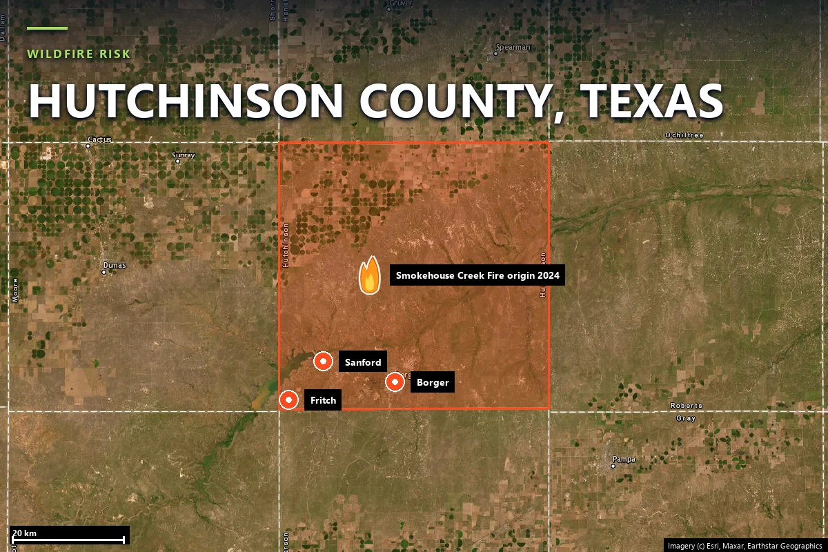
On 26 February 2024 a broken utility pole a mile north of Stinnett started
the Smokehouse Creek Fire, which burned 1,058,482 acres —
the largest wildfire Texas has ever recorded. The next day a second fire
crossed Highway 136 into Fritch, a town that had already lost 225 homes in
2014. A Satelife report for a Fritch address returns 59 / 100 — High — and a
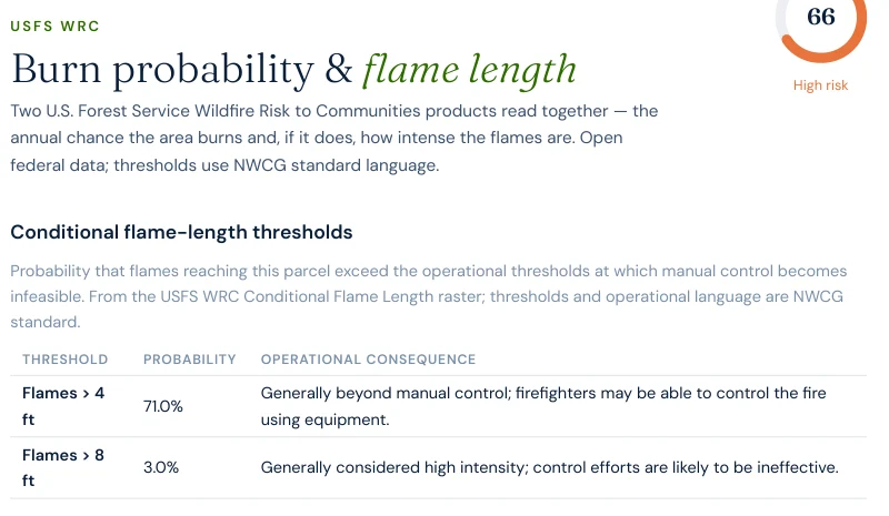
71.0% modelled probability of four-foot flames.
The Texas Panhandle burns differently from the rest of the state, and Hutchinson County is
where that difference produced a record. After a warm, dry winter left the short- and
mixed-grass prairie cured, a storm system crossed the southern High Plains on 26–27 February
2024 with extreme winds. A broken utility pole roughly one mile north of Stinnett dropped a
line into that grass.
Smokehouse Creek Fire — ignited 26 February 2024, Hutchinson County. Final size 1,058,482 acres, two fatalities, roughly $1 billion in damage. It overtook the 2006 East Amarillo Complex (907,245 acres) to become the largest wildfire in Texas history, and was not fully contained until mid-March.
Windy Deuce Fire — the same weather system, burning west of Lake Meredith. On 27 February it crossed Highway 136 into Fritch, destroying more than 90 homes. Evacuated neighbourhoods included Double Diamond, Arrowhead Addition, Alibates, McBride, Harbor Bay and Chisolm Trail.
Double Diamond Fire — 11 May 2014, near Fritch. 2,202 acres, and yet 225 residences and 143 outbuildings destroyed: a cold front swung the wind to the north at 21 mph gusting 45, and the fire travelled more than four and a half miles in a little over five hours while about 2,100 people evacuated.
Note the relationship between those two Fritch numbers. The 2014 fire burned
2,202 acres and destroyed 225 homes. The 2024 fire that reached the same town
was part of a complex of over a million acres. Acreage is not what determines structure loss
here — wind direction and where the town sits relative to the grass are.
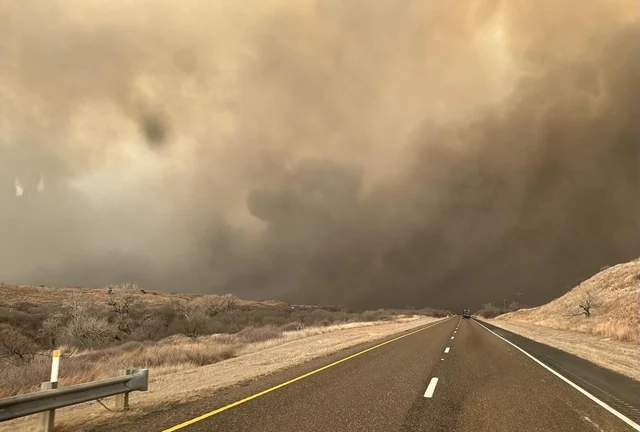
Smoke crossing a road on the Smokehouse Creek Fire, afternoon of 27 February 2024. Source:
InciWeb incident photo gallery, via
Wikimedia Commons
(public domain).
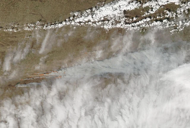
The burn scar on 2 March 2024 — over a million acres of Panhandle prairie. Source: MODIS
Land Rapid Response Team, NASA GSFC, via
Wikimedia Commons
(public domain).
Sources: Texas A&M Forest Service · InciWeb incident updates · NIFC / WFIGS fire perimeters
(via the Satelife fire-history layer) · USDA NASS 2024 Texas Wildfires assessment.
Terrain & fuel
Grass is a fuel that is always nearly ready
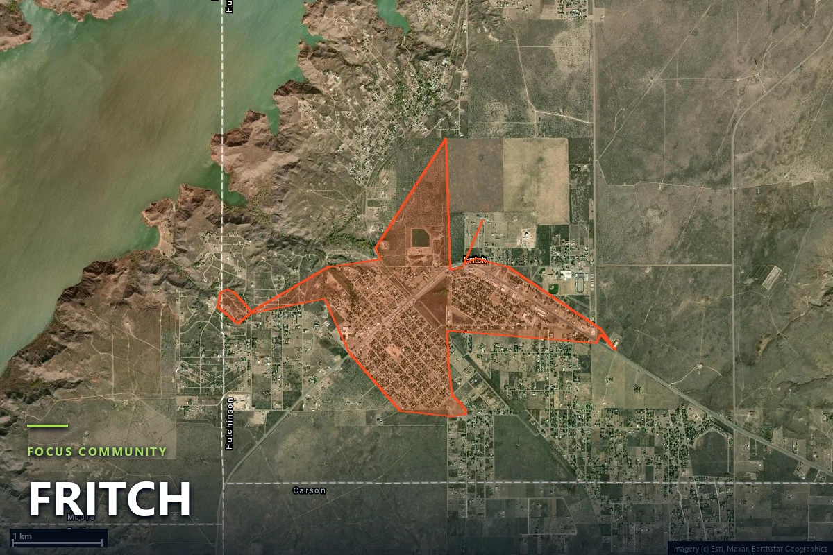
Fritch is a small town of about 373 hectares sitting on the breaks above Lake Meredith, at the
edge of the Canadian River canyon system, surrounded by Western Great Plains short-grass and
mixed-grass prairie. Satelife's community analysis grids the town into
159 zones and scores the area vegetation layer at 66 / 100 —
the highest of the three Texas counties we publish, and more than three times the
corresponding figure for the regrown pine at Tahitian Village in Bastrop County.
Two things follow from a grass fuel bed. The first is timing: grass cures within days of a dry,
windy spell rather than over a summer, so the Panhandle's destructive season is
late winter and early spring — both the 2014 and 2024 Fritch fires were
February and May events, not August ones. The second is speed. The terrain layer for the
Lakeview Drive parcel reads 65 / 100 on the relief of the breaks, and
thirty-year ERA5 fire-weather climatology reads 70 / 100 — the hottest and
driest of our three Texas case studies.
What makes the county's profile unusual is that the hazard layer agrees. Across most of Texas,
the U.S. Forest Service Wildfire Risk to Communities backfill Satelife uses in place of the
hazard-zone map Texas does not publish pulls a composite down. In Fritch it reads
66 / 100 — High.
Evacuation
One station, 1.2 minutes, no second option
Fritch has the fastest modelled fire-service response of any community we have analyzed, in
either state — and the thinnest. The community analysis finds one OSM-mapped station inside the
boundary, and everything is close to it:
1.2 minmodelled drive-time from the Fritch Fire Department
1OSM-mapped fire station serving the analyzed area
38independent road exits from the analyzed Fritch area
0.3–3.0 minmodelled drive-time to the town's top hotspot zones
Thirty-eight exits across 159 analysis zones is 4.2 zones per exit — the best
egress ratio of our three Texas counties, and a straightforward consequence of a grid town on
flat ground rather than a subdivision on a bluff. The modelled network still narrows to a
24.5-metre single point somewhere in that grid, but the dominant constraint
here is not geometry.
It is capacity. A 1.2-minute response is decisive against one structure fire and irrelevant
against a wind-driven front arriving on a mile-wide flank, which is what February 2024
delivered. What actually scaled that day was mutual aid from Borger, Stinnett, Sanford and
further out, plus state resources — and none of that is visible to a parcel-level access model.
Read the 1.2 minutes as how fast the first engine arrives, not how much engine
there is.
Fire behaviour
A 71% chance of flames beyond hand-crew control
The clearest single number on this page comes from the USFS Wildfire Risk to Communities
conditional flame-length raster, which models how intense flames reaching a parcel would be if
it burns. For the Lakeview Drive property in Fritch:
Report excerpt — USFS WRC burn probability & flame length, Satelife
Wildfire Risk Report, Lakeview Drive, Fritch TX 79036 (July 2026). Thresholds and operational
language are NWCG standard.
Four feet is the operational threshold at which direct attack by hand crews stops working and
the fight becomes an equipment-and-air-support problem; eight feet is where control efforts are
generally ineffective. 71.0% and 3.0% respectively is a fuel
bed telling you that if fire reaches this parcel, it will most likely arrive in a form people
with tools cannot stop.
For scale: the same model returns 28.1% at our Tahitian Village parcel in
Bastrop County,
28.1% at Alta Sierra in
Nevada County,
California — a county the California insurance regulator ranks third in the state for
high-risk exposure — and 0.0% at our Steiner Ranch parcel in
Travis County.
Fritch is in a different band from all of them.
Grassland risk gets dismissed because grass fires are small in duration and thin in flame
depth. The federal model does not dismiss it: on this parcel it puts flames beyond hand-crew
control at seven chances in ten.
Case study
One address on Lakeview Drive, scored today
We ran a full Satelife wildfire-risk report for a property on Lakeview Drive, Fritch
TX 79036 — in the town that lost 225 homes in 2014 and more than 90 in 2024. The
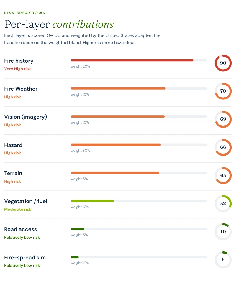
composite: 59 / 100 — High tier, at 0.82 confidence, from eight
independently-scored and weighted layers. It is the highest composite we have published for a
Texas address.
Report excerpt — Per-layer contributions, Satelife Wildfire Risk Report,
Lakeview Drive, Fritch TX 79036 (July 2026). Composite 59/100, High tier, scored under the
United States (usa_generic) adapter.
What drives the score — and this is the rare case where nearly everything points the same way:
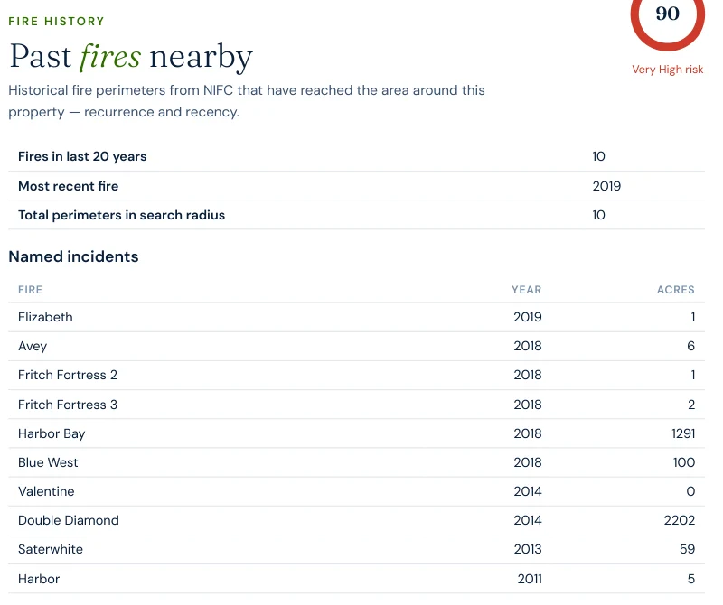
Fire history: 90/100, weight 20%. This run's sample lists ten mapped perimeters, all ten inside the last twenty years — enough to max the count term. The national services actually hold at least sixteen within the same 5 km radius, so ten is a floor, not the total.
Hazard: 66/100, weight 30%. Backfilled from the USFS WRC model. At most Texas addresses this backfill suppresses the composite; here it is the second-largest contributor.
Fire weather: 70/100. Thirty-year ERA5 climatology of the Canadian Fire Weather Index — the highest of our Texas case studies.
Terrain: 65/100. The broken ground of the Canadian River breaks above Lake Meredith.
AI vision analysis: 69/100. The model reads the parcel's own imagery and finds a low-density setting with mostly managed groundcover, but trees and shrubs present near the structure and along the frontage.
Report excerpt — Fire history, same report. Two separate limits shaped this
table. The sample was capped at ten records, so it shows ten of the sixteen-plus perimeters
the services hold within the radius; and it ends in 2019 because the certified
national history has nothing more recent here — the 2024 Windy Deuce and Smokehouse Creek
perimeters live in the operational feed, which did not answer on this run. The 2024 figures
elsewhere on this page come from Texas A&M Forest Service and InciWeb instead. The record
cap has since been removed and a failed operational feed is now disclosed on the report
itself rather than passing silently.
The 2014 Double Diamond Fire is in the table at 2,202 acres. The 2024 fires that burned into
the same town are not in it at all. A fire-history layer is a record of what has been mapped
and certified — never treat an absence in it as an absence on the ground.
The mitigation plan the report generates for this parcel is correspondingly blunt, and it leads
with the structure rather than the landscape: establish a Zone 0 ember-resistant perimeter in
the first five feet, harden roof and vents against ember intrusion, then maintain thirty feet
of lean, clean and green space. In a grass-driven event the ember cast arrives before the
flaming front, and vents are how a house that the fire never touched still burns down.
Insurance & real estate
What a second total loss does to coverage
Hutchinson County is a small market — roughly 20,000 people across Borger, Fritch, Stinnett and
Sanford — and small markets absorb repeat catastrophe badly. Agricultural and property losses
across the Panhandle from the February 2024 fires ran past $123 million, on top
of the roughly $1 billion in total damage attributed to Smokehouse Creek. For a homeowner in
Fritch, the underwriting question after 2024 is not whether the area burns; it is whether this
particular parcel can be shown to be defensible.
Texas offers no statutory help with that argument. There is no fire-hazard-severity zone map to
appeal to, no mitigation-discount mandate comparable to California's SB 1060, and the Texas
Property Code §5.008 Seller's Disclosure Notice contains no wildfire-designation item. The
backstop is the Texas FAIR Plan Association, the residential insurer of last
resort administered under the Texas Department of Insurance, which you become eligible for only
after two carriers actively writing in Texas have declined you — narrower and more expensive
coverage, reached by failing the market rather than by choosing it.
That makes dated, parcel-level evidence the practical currency: what the fuel around the
structure looks like, what the vents and roof are, what was cleared and when. See
Texas wildfire risk for how the
state-level picture fits together.
Sources: Texas Department of Insurance · Texas FAIR Plan Association · Texas A&M AgriLife /
Texas A&M Forest Service Panhandle loss estimates.
Risk reduction
What Hutchinson County homeowners can actually do
In a grass regime the defensible-space priority order inverts relative to forest. Zone 0 — the
first five feet against the wall, kept free of combustibles, mulch, stored fuel and vegetation —
does more work than any amount of clearing at thirty metres, because the failure mode is ember
ignition of the structure itself rather than crown fire arriving through canopy. Roof and vent
hardening comes next. Fritch has run community prevention programming with the Red Cross,
Team Rubicon and the Fritch Volunteer Fire Department since 2024, and Hutchinson County has an
active partnership with Texas A&M Forest Service on prevention work.
Set against our other Texas pages, the county's profile is distinctive on almost every axis.
Fritch: composite 59 / 100 High, four-foot flame probability
71.0%, fire weather 70, one station at 1.2 minutes, 4.2 zones per exit.
Tahitian Village,
Bastrop County: 46 / 100 Moderate, 28.1%, fire weather 59, four stations, 14.9 zones per
exit and a single approach route.
Steiner Ranch, Travis
County: 27 / 100 Moderate, 0.0%, 5.6 zones per exit. Bastrop's constraint is the road;
Travis's is the interface; Hutchinson's is the fuel itself, and the fuel is the hardest of the
three to change.
Coverage
ZIP codes we cover in Hutchinson County
Satelife runs address-level wildfire reports across every ZIP code in Hutchinson County.
The ZIPs below are the Panhandle grassland and Wildland-Urban Interface
communities we are asked about most. One caveat that is the whole point of what we
do: the risk score is computed for your parcel, not the ZIP, so two
homes on the same street can land in different tiers. Find your area, then
run your address.
ZIP code
Community
Why it is on the map
79036
Fritch
Lake Meredith WUI; Lakeview Drive case study, burned 2014 and 2024
79007
Borger
County’s largest city; refinery corridor inside continuous grassland
79083
Stinnett
County seat; the Smokehouse Creek Fire started a mile north
79078
Sanford
Canadian River breaks above Lake Meredith
79008
Borger (PO boxes)
Same delivery area as 79007
ZIP areas per USPS; Hutchinson County has a small ZIP set and all of it is listed. Texas publishes no statewide fire hazard severity zone map; Wildland-Urban Interface framing per Texas A&M Forest Service.
Frequently asked questions about Hutchinson County wildfire risk
Is Hutchinson County the highest wildfire risk county in Texas?
It is where the largest wildfire in Texas history started. The Smokehouse Creek Fire ignited on 26 February 2024 about a mile north of Stinnett, in Hutchinson County, and burned 1,058,482 acres. A Satelife property report in Fritch returns 59 / 100 in the High tier, with the USFS model putting the probability of flame lengths over four feet at 71.0% — the highest figure we have published on any county page, in Texas or California.
How many times has Fritch burned?
Twice in ten years. The Double Diamond Fire of 11 May 2014 destroyed 225 residences and 143 outbuildings and moved more than four and a half miles in about five hours. On 27 February 2024 the Windy Deuce Fire jumped Highway 136 into the town and destroyed more than 90 homes; the neighbourhoods evacuated included Double Diamond — the same subdivision, ten years later, while the Smokehouse Creek Fire burned to the east.
Why does grassland burn worse than forest here?
Because grass carries fire faster and needs almost nothing to be ready. Short and mixed-grass prairie cures within days of a dry, windy spell, so the Panhandle fire season peaks in late winter and early spring — February and March — not late summer. The Satelife community analysis of Fritch scores the area vegetation layer at 66 / 100, the highest of our three Texas counties, and the fire-history layer at 90 / 100.
What is the fire-station coverage in Fritch?
One mapped station, and it is close. The community analysis finds a single OSM-mapped fire station — the Fritch Fire Department — with a modelled 1.2-minute drive-time and hotspot-zone drive-times of 0.3 to 3.0 minutes. That is excellent reach and zero redundancy: a 1,000,000-acre fire front does not queue. Mutual aid from Borger, Stinnett and Sanford is what actually scales, and it is not something a parcel-level model can score.
Does Texas have a fire hazard severity zone map for the Panhandle?
No. Texas publishes no statewide fire-hazard-severity zoning equivalent to California’s CAL FIRE FHSZ, so Satelife’s hazard layer is backfilled from the U.S. Forest Service Wildfire Risk to Communities model. For the Fritch parcel that backfilled layer reads 66 / 100 — High — which is unusual: in most Texas locations the backfill pulls the composite down, and here it does not.
Scores and evacuation figures on this page are drawn from Satelife wildfire-risk reports generated
on 25 July 2026 under the United States (usa_generic) adapter: a property report for Lakeview Drive,
Fritch TX 79036, and a community analysis of the Fritch city boundary. Texas publishes no statewide
fire-hazard-severity map, so the hazard layer is backfilled from the USFS Wildfire Risk to
Communities model. The fire-history layer reads mapped NIFC/WFIGS perimeters; the run quoted here
returned a sample capped at ten records ending in 2019, which understates both the perimeter count
and the recency for this parcel, so the 2024 Smokehouse Creek and Windy Deuce figures on this page
come from Texas A&M Forest Service and InciWeb. Drive-times are modelled on OSM-mapped stations and
the current road graph and do not represent mutual-aid capacity. Satelife reports are informational
decision support — not a substitute for official evacuation orders, state or federal hazard
determinations, or an insurer's underwriting judgement.
What does your parcel look like, layer by layer?
If you own or are buying in Hutchinson County — Fritch, Borger, Stinnett or Sanford — get the address-level answer: PDF, per-layer score, and a prioritized mitigation plan.