Wildfire risk in Butte County: what the numbers look like after the worst case
In 2018 the Camp Fire burned 153,336 acres and destroyed the town of
Paradise. Run a Satelife report on a Paradise street today and the
composite comes back 48 / 100 — Moderate. That number is not good news.
This page takes it apart layer by layer and shows which parts of it
have an expiry date.
The county that produced California's deadliest fire
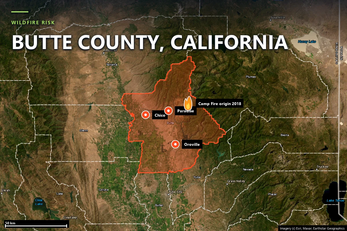
Butte County runs from the Sacramento Valley floor at Chico and Oroville up onto the
western slope of the northern Sierra Nevada. Between the two sits the Ridge — a long
finger of high ground between Butte Creek and the West Branch of the Feather River,
carrying Paradise, Magalia and Stirling City. That ridge is where the county's
population meets its fuel, and it is where its fire record was written.
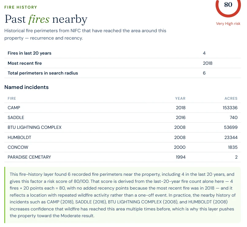
The fire-history layer in a Satelife report for a Paradise address finds
six mapped perimeters reaching the parcel, four of them in the
last twenty years. The named incidents, straight out of the NIFC perimeter set:
Camp Fire (2018) — 153,336 acres, 18,804 structures destroyed and 85 lives lost. It ignited at 6:33 a.m. on November 8 where the PG&E Caribou–Palermo transmission line crosses Camp Creek Road near Pulga, drove west onto the Ridge on a dry offshore wind, and destroyed the town of Paradise while devastating neighbouring Concow and much of Magalia. It remains both the deadliest and the most destructive wildfire in California history.
BTU Lightning Complex (2008) — 53,699 acres across the county's forested east side.
Humboldt Fire (2008) — 23,344 acres on the Chico–Paradise interface.
Concow Fire (2000) — 1,835 acres, in the same canyon the Camp Fire would later run through.
Saddle Fire (2016) — 740 acres, two years before the Camp Fire.
Read that list as a frequency statement rather than a highlight reel. Four fires in
twenty years is why the fire-history layer for this parcel scores 80 / 100 —
Very High: the score is driven by recurrence, and this location has been
reached repeatedly rather than once.
The county's exposure did not end in 2018, and it is not confined to the Ridge. Two of
California's largest recorded wildfires have ignited inside Butte County since: the
Dixie Fire (2021), which started above Cresta Dam in the Feather River
Canyon and grew to 963,309 acres across five counties — the
second-largest in state history — and the Park Fire (2024), an arson
ignition off Upper Park Road in Chico's Bidwell Park that reached
429,603 acres, the fourth-largest on record. The
North Complex (2020) ignited by lightning in the Plumas National Forest
but made its destructive run southwest into Butte County on September 8, taking Berry
Creek and Feather Falls, destroying 2,352 structures and killing 15 people.
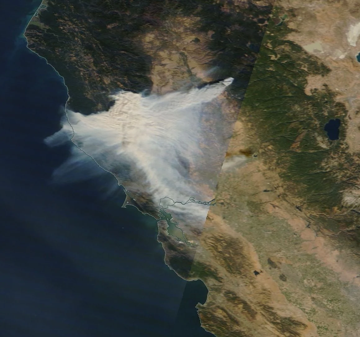
The Camp Fire's plume on the day of ignition, November 8, 2018 — smoke from a single
Butte County ignition covering the Sacramento Valley and the Bay Area. Source: NASA
Worldview / EOSDIS, via
Wikimedia Commons
(public domain).
Sources: NIFC fire perimeters (via Satelife fire-history layer) · CAL FIRE Incident Archive · NASA Worldview.
Terrain & vegetation
A town on a ridge, with canyons on both sides
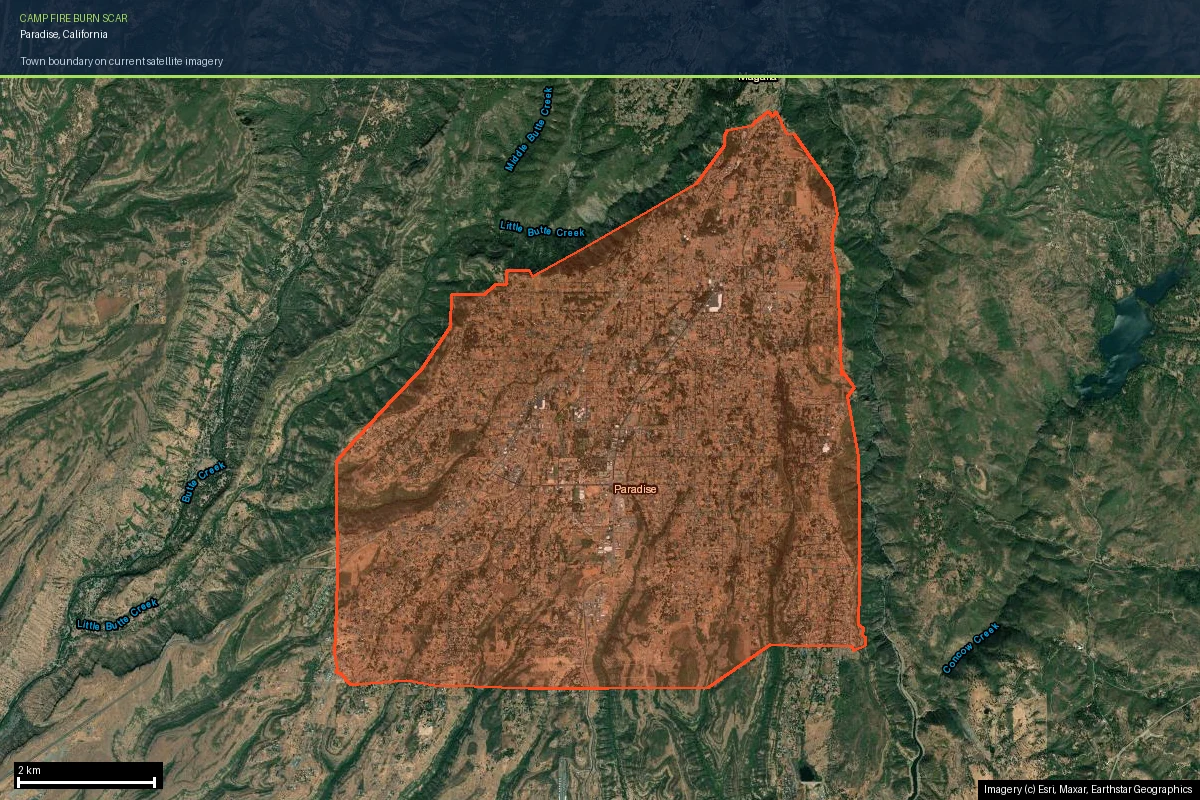
Look at where Paradise physically sits. The town occupies the crown of a ridge with
Little Butte Creek canyon on one flank and the West Branch Feather River canyon on the
other. Both drop away steeply into unbroken timber. That is the geometry that made
November 8, 2018 unsurvivable for so much of the town: a wind-driven fire in a canyon
below a ridgeline community arrives with terrain-driven momentum and a wall of embers
running ahead of it.
The terrain layer in Satelife's Paradise analysis scores 65 / 100 on
slope and aspect alone, before any vegetation is counted — and terrain is the one input
on this page that will never change. The canyons are permanent; so is the fact that the
escape routes off the Ridge run along it rather than across it.
The fuel picture is the part that did change. The vegetation layer currently reads
26 / 100 for the parcel, and the community-scale analysis of the whole
town reads much the same. That is not a mitigation success — it is the burn scar. The
pre-2018 mixed-conifer and oak-woodland fuel bed that carried the Camp Fire is largely
gone, and what replaces it is brush and young regrowth that will carry fire faster than
the mature forest it succeeded.
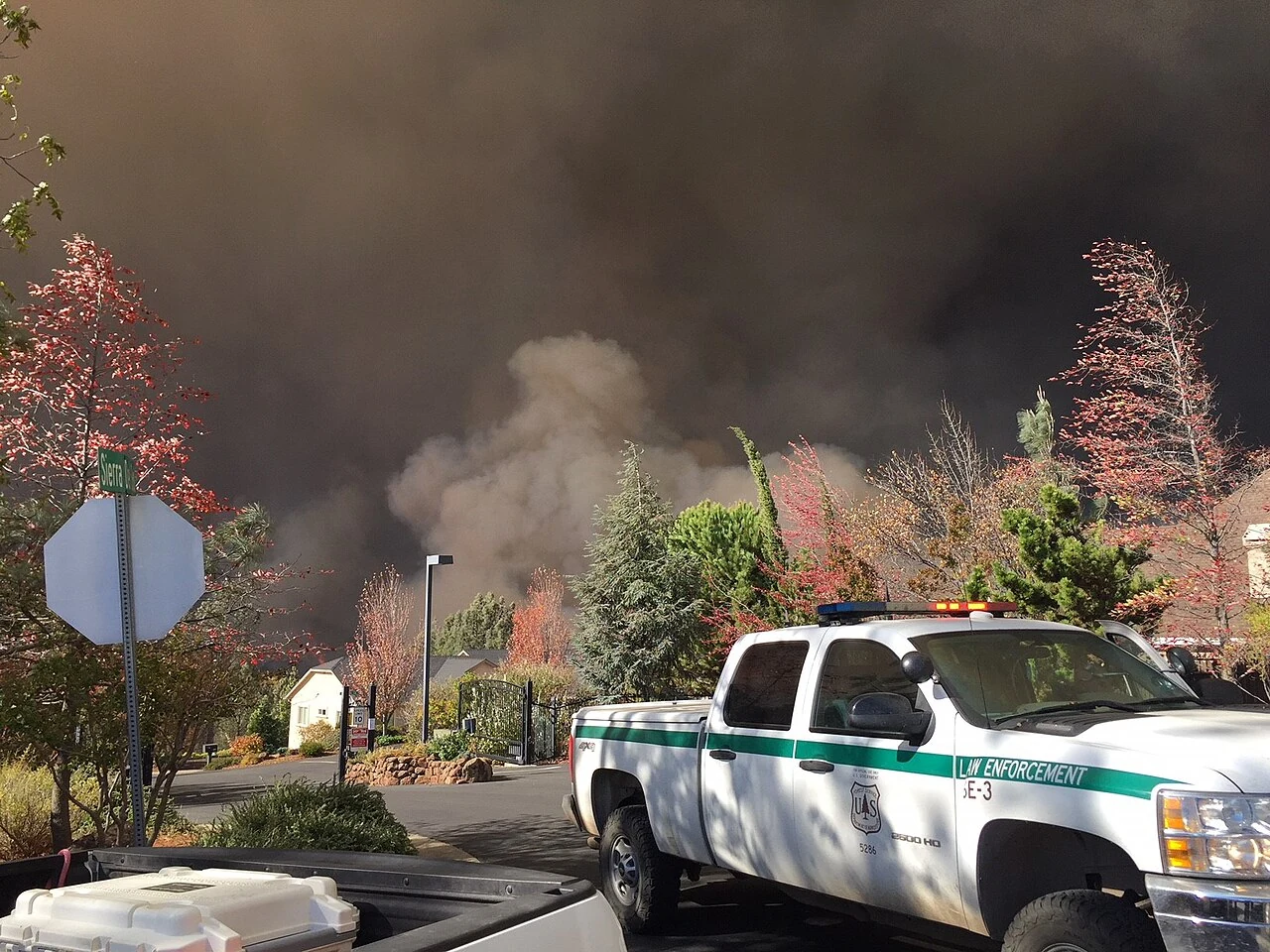
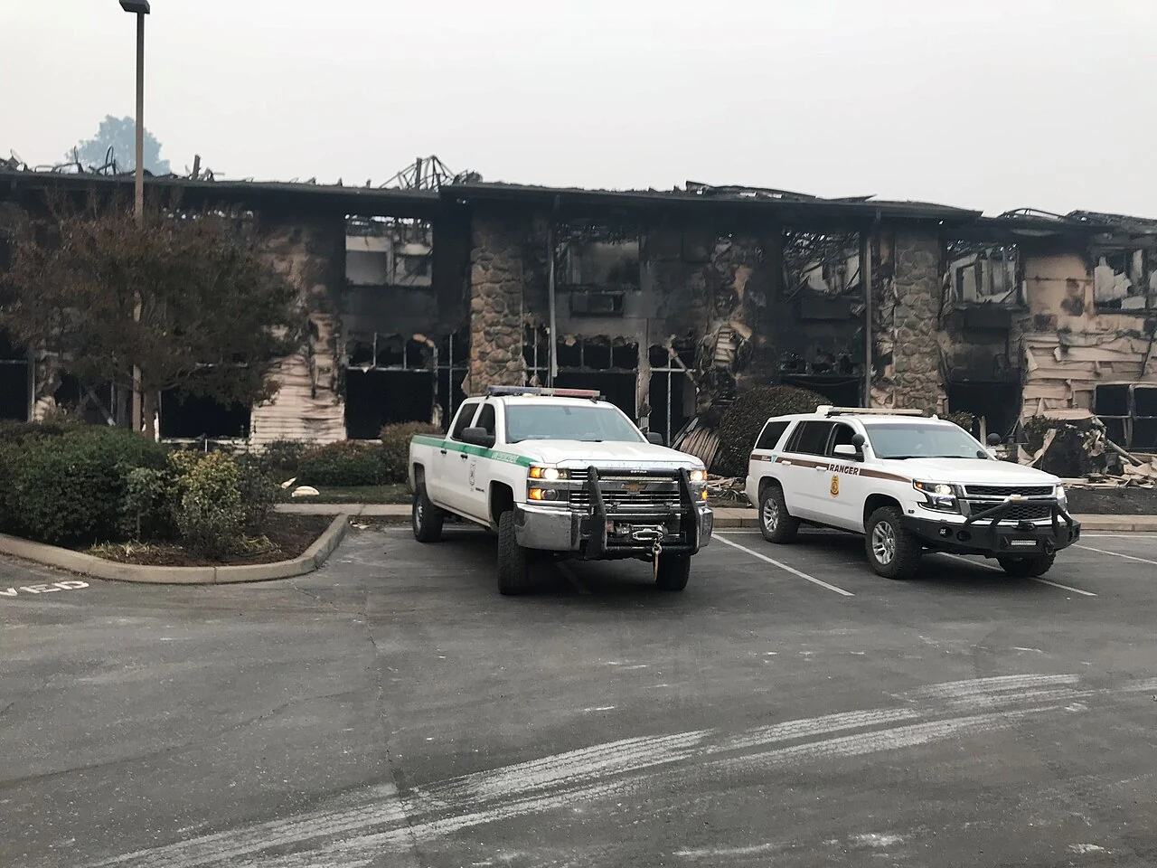
The Camp Fire arriving behind a residential street, November 2018 — the WUI edge as it
actually presents. Source: Forest Service Photography, via
Wikimedia Commons
(public domain).
Evacuation
The one layer where Paradise now measures better than its neighbours
This is where a Butte County page has to be honest about something counterintuitive.
Evacuation capacity is normally the worst number on a ridge-community page — it is the
thing hazard maps cannot see, and the thing that killed people here in 2018. Satelife's
community-scale analysis of the Town of Paradise gridded 4,679 hectares into 426
analysis zones and rebuilt the picture from the current road graph. The result is the
strongest egress profile we have measured on any California county page so far:
33independent road exits from the analyzed area
12.9analysis zones per exit route
2.9 minmodelled fire-truck drive-time from Paradise Fire Department #82 (2.04 km)
5–10 minmodelled drive-time to the town's top hotspot zones
Thirty-three independent exits, seven fire stations within fifteen kilometres, and a
modelled response of under three minutes to the nearest station. Compare that with
Grizzly Flats in
El Dorado County,
where the same analysis found nine exits and a 32-minute drive-time from the nearest
mapped full-time station.
It is worth being precise about why Paradise measures well, because the obvious
explanation is the wrong one. The town's headline evacuation projects are not finished:
the Upper Skyway widening — a centre turn lane and widened shoulders
between Bille and Wagstaff Roads — is scheduled for completion in 2028,
and the Roe Road extension, the planned southeast evacuation route, was
still in design and public comment through early 2026. What has actually changed is the
load on the existing network. Paradise held 26,711 residents in 2018;
the 2020 Census counted 4,764, and California's Department of Finance
put the town at 10,581 as of January 2026. That is roughly 40% of the
pre-fire population on substantially the same road graph — plus town-wide fuel reduction
along about 99 miles of right-of-way. Good egress numbers here are a function of how few
people are left to move, and they will tighten again as the rebuild continues.
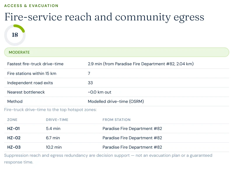
Report excerpt — Access & Evacuation, Satelife Neighborhood Wildfire
Risk Report for Paradise, CA (July 2026). Modelled OSRM drive-times from OSM-mapped
stations, measured on the current road network. Decision support, not an evacuation plan
or a guaranteed response time.
A hazard map scored Paradise the same in 2017 and in 2026. What changed underneath it is
how many people that road network has to move — and only a model built on the current
graph and the current build-out can tell you that.
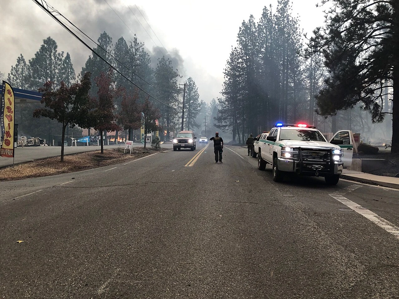
The evacuation corridor during the Camp Fire, November 2018. Source: Forest Service
Photography, via
Wikimedia Commons
(public domain).
The post-fire cycle
Why a Moderate score here is a statement about timing
Three of the ten layers in the Paradise property report currently read low, and all
three read low for the same reason: there is nothing left to burn yet.
USFS Wildfire Risk to Communities: 8 / 100. The federal burn-probability and flame-length model reads a landscape stripped of fuel.
Probability of flame lengths over four feet: 0.0%. Not a rounding artefact — the modelled fuel bed at this location cannot currently produce them.
Fire-spread simulation: 6 / 100. Across 30 modelled ignitions placed upwind in seasonal wind regimes, fire reached the property in 2 of them — 6.67% of scenarios — with a modelled time-of-arrival of 195 to 215 minutes.
Now look at what did not move:
Hazard classification: 90 / 100. CAL FIRE's Fire Hazard Severity Zone model scores long-term hazard from climate, terrain and fire behaviour over decades. Paradise is Very High, exactly as it was on November 7, 2018.
Fire history: 80 / 100. Four fires in twenty years is a property of the place, not of this season.
Terrain: 65 / 100. Permanent.
Fire weather: 56 / 100. The thirty-year climatology that dried the fuels in 2018 is still there, and trending the wrong way.
A composite of 48 built from those two lists is not the same object as a composite of 48
built from ten middling layers. The low numbers are a fuel-cycle artefact with an expiry
date measured in years; the high numbers are structural. Every home rebuilt during the
reprieve will spend the overwhelming majority of its service life inside the next fuel
cycle, not this one.
To make the county's risk concrete, we ran a full Satelife wildfire-risk report for a
property on Pearson Road, Paradise — inside the rebuilt town, inside
the burn scar, inside the Very High zone. The composite score:
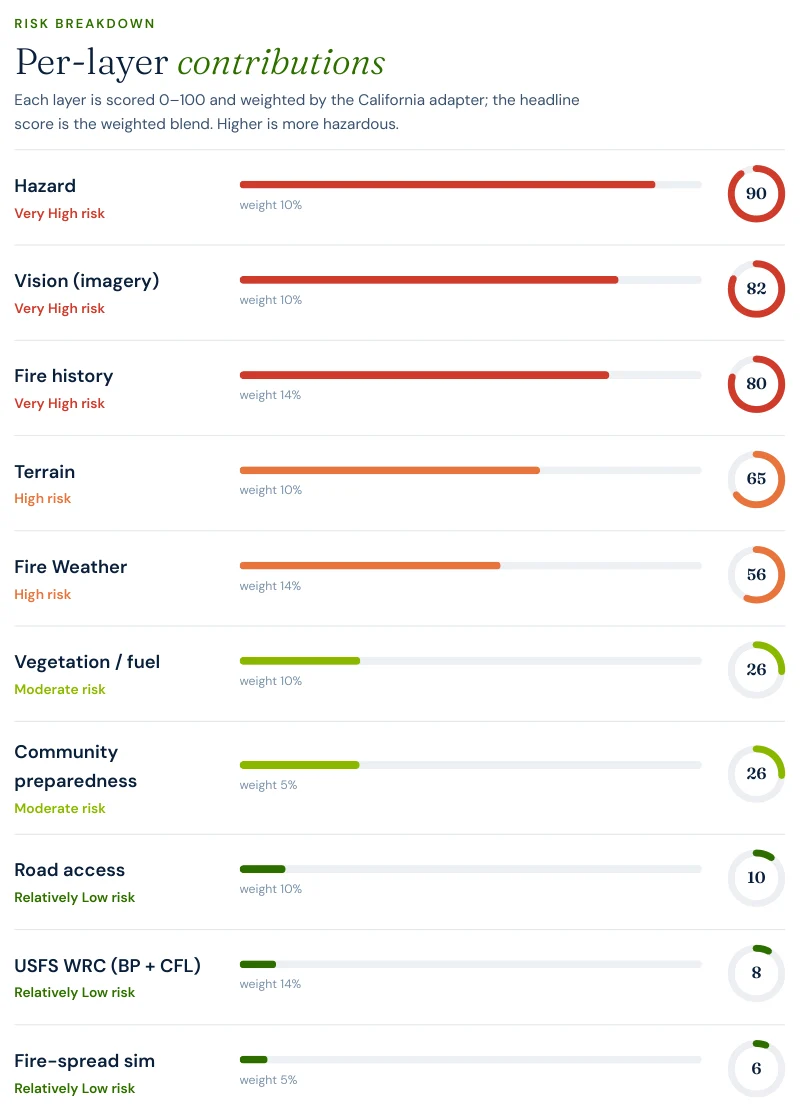
48 / 100 — Moderate tier, at 0.87 confidence, built from ten
independently-scored layers rather than one hazard polygon.
Hazard zone: 90/100. The parcel sits squarely in CAL FIRE's Very High Fire Hazard Severity Zone.
AI vision analysis: 82/100 — the highest non-hazard layer. The model reads aerial and street-level imagery of the actual parcel and finds mature trees and substantial green vegetation immediately around the structure, canopy extending toward or above parts of the roofline, and defensible space that is partial rather than complete. Eight years on, the vegetation at the parcel scale has come back even where the landscape-scale fuel has not.
Fire history: 80/100 — and it names the Camp Fire. Four fires in twenty years, most recent 2018, with CAMP (153,336 acres) heading the incident list.
Road access: 10/100. Genuinely good, and worth stating plainly — the modelled suppression reach and egress at this parcel are an asset rather than a liability, which is not what most Very-High-zone parcels return.
Report excerpt — Fire history: six mapped NIFC perimeters have reached
this parcel, four of them since 2006. The layer scores recurrence, not severity.
The FHSZ polygon says "Very High" for every parcel in Paradise equally. The report says
this house has canopy over the roofline and partial clearance at 34 metres —
and which two actions, in order, change that.
The report pairs the score with a prioritized plan for this exact parcel: audit
defensible space annually before fire season, and verify access-route width and gate
clearance. Both are unglamorous, and both are the kind of documented, dated evidence
that the Safer from Wildfires mitigation-discount pathway is built to consume.
Insurance & real estate
What a rebuilt market looks like from underwriting
Butte County homeowners meet all of the above through their insurance bill. The pattern
across the county's WUI communities since 2018 has been carrier non-renewals followed by
migration to the California FAIR Plan, the state's insurer of last
resort, which reported 668,609 policies in force in December 2025 — a
146% increase since September 2022 — against total exposure of roughly $724 billion.
FAIR Plan coverage is more expensive and thinner than the admitted-market policies it
replaces.
Paradise is an unusually clean test of whether documentation changes that. Much of the
town's housing stock is now post-2018 construction built to Chapter 7A ember-resistant
standards — newer and more defensible than almost any comparable WUI community in
California. California's Safer from Wildfires regulation
(10 CCR § 2644.9, effective October 2022) requires every admitted insurer that prices on
wildfire risk to offer discounts for twelve specific mitigation measures across three
layers: the structure itself, the immediate surroundings and defensible space, and
community-level designations such as Firewise USA. That only helps a homeowner who can
evidence what their parcel actually looks like. A zone map cannot do that; an
address-level report can.
For buyers and sellers, California Civil Code §1103 requires Natural Hazard Disclosure at
the point of sale — and as insurance availability tightens, fire-zone status becomes a
closing-risk variable rather than a paperwork item. A buyer who cannot bind insurance
cannot close. See
California wildfire insurance
and
California real estate wildfire risk.
Sources: California Department of Insurance · California FAIR Plan · 10 CCR § 2644.9 (Safer from Wildfires) · California Building Code Chapter 7A.
Risk reduction
What Butte County homeowners can actually do
CAL FIRE's defensible-space framework defines three zones: Zone 0 (0–5 ft,
ember-resistant, no combustibles), Zone 1 (5–30 ft, lean-clean-green), and Zone 2
(30–100 ft, reduced fuel). In a post-fire landscape the maintenance interval matters
more than the initial clearance — regrowth on the Ridge is fast and flashy, and the
vision layer above is already picking up canopy encroachment on parcels that were bare
ground a few years ago. A property that passed inspection in 2024 is not necessarily
compliant in 2026. Locally, the Butte County Fire Safe Council — based on
Clark Road in Paradise — runs chipping, hazardous-tree removal and Firewise USA support,
which is the neighborhood-scale version of the same work.
The instructive comparison is with
Nevada County,
ninety minutes south. Our Alta Sierra case study there scores
48 / 100 — statistically the same composite as Pearson Road — from the
opposite direction. Paradise: fire history 80, USFS WRC 8, probability of four-foot
flames 0.0%. Alta Sierra: fire history 20, USFS WRC 49, probability of four-foot flames
28.1%. One community has already spent its fuel and kept its hazard;
the other has kept both. Two identical headline numbers, two completely different
instruction sets.
If you only ever see the composite, Paradise and Alta Sierra look like the same risk.
They are almost exact opposites — and the mitigation money should go to different places
in each.
Coverage
ZIP codes we cover in Butte County
Satelife runs address-level wildfire reports across every ZIP code in Butte County.
The ZIPs below are the high Fire Hazard Severity Zone, Wildland-Urban Interface
communities we are asked about most. One caveat that is the whole point of what we
do: the risk score is computed for your parcel, not the ZIP, so two
homes on the same street can land in different tiers. Find your area, then
run your address.
ZIP code
Community
Why it is on the map
95969
Paradise
Camp Fire (2018) destroyed the town; Pearson Road case study
95954
Magalia
Ridge community above Paradise, burned in 2018
95978
Stirling City
Top of the Skyway ridge, single-corridor forest WUI
95942
Forest Ranch
Timbered WUI on the Highway 32 corridor above Chico
95916
Berry Creek
Destroyed by the 2020 North Complex; steep canyon WUI
95965
Oroville
Feather River canyon interface at the county core
95940
Feather Falls
Remote canyon community, long fire-service drive-times
95928
Chico
Urban edge against Bidwell Park and the upper Ridge
ZIP areas per USPS; Wildland-Urban Interface and Fire Hazard Severity Zone framing per CAL FIRE.
Frequently asked questions about Butte County wildfire risk
Is Butte County a high wildfire risk area?
Yes. The county’s populated foothill and ridge belt — Paradise, Magalia, Concow, Berry Creek, Forest Ranch and the Feather River canyon communities — sits in CAL FIRE High and Very High Fire Hazard Severity Zones. A current Satelife hazard layer for a Paradise address still reads 90/100, eight years after the Camp Fire burned the town.
What was the largest wildfire in Butte County?
The 2018 Camp Fire. The NIFC perimeter that reaches a Paradise parcel in a Satelife fire-history layer measures 153,336 acres. It remains the deadliest and most destructive wildfire in California history: it destroyed the town of Paradise and devastated neighbouring Concow and much of Magalia, taking 18,804 structures and 85 lives.
Is it safe to live in Paradise, California now?
The hazard classification did not reset. Paradise remains in a Very High Fire Hazard Severity Zone and the Satelife hazard layer still scores 90/100 there. What has changed is everything downstream of the hazard: the fuel bed largely burned, the town now holds roughly 40% of its pre-fire population on substantially the same road network, and modelled fire-service response into the town is among the fastest we have measured anywhere in California. The composite score for our Pearson Road case study is 48/100 — Moderate — but the drivers behind that number are temporary, and the major evacuation-route projects are not finished (the Upper Skyway widening is scheduled for 2028).
How do I check the fire hazard zone for my Butte County address?
Use the CAL FIRE FHSZ viewer for the official Moderate / High / Very High classification. For property-level detail — terrain, fuels, fire history, evacuation constraints, and an AI read of your actual parcel imagery — run a Satelife address-level report.
Does rebuilding to the new codes lower my wildfire risk in Paradise?
It changes the part of the risk you control. Chapter 7A ember-resistant construction and a maintained Zone 0 address the ignition pathway that destroyed most structures in 2018 — ember intrusion, not a flame front. The hazard zone, terrain and climate layers stay where they are. Under California’s Safer from Wildfires regulation, documenting that work is also what feeds the mitigation-discount pathway with your carrier.
Scores and evacuation figures on this page are drawn from Satelife wildfire-risk reports
generated in July 2026 (property report, Pearson Road, Paradise CA 95969; neighborhood
analysis, Town of Paradise boundary). Drive-times are modelled on OSM-mapped fire stations
and the current road graph. Satelife reports are informational decision support — not a
substitute for official evacuation orders, CAL FIRE hazard determinations, or an insurer's
underwriting judgement.
What does your parcel look like, layer by layer?
If you own, are buying, or are rebuilding in Butte County — Paradise, Magalia, Concow, Berry Creek, Forest Ranch or the Feather River canyon — get the address-level answer: PDF, ten-layer score, and a prioritized mitigation plan.