Wildfire risk in Placer County: the ridge that keeps burning
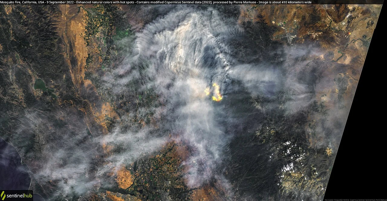
The 2022 Mosquito Fire — 76,788 acres, California's largest fire that year — ignited
near Oxbow Reservoir a few miles from Foresthill and burned for 46 days. Communities sit
on a single forested ridge between two river canyons. This page maps Placer County's
structural wildfire risk with satellite data and a real property-level report from
inside Foresthill.
A county whose worst fire started at a reservoir near Foresthill
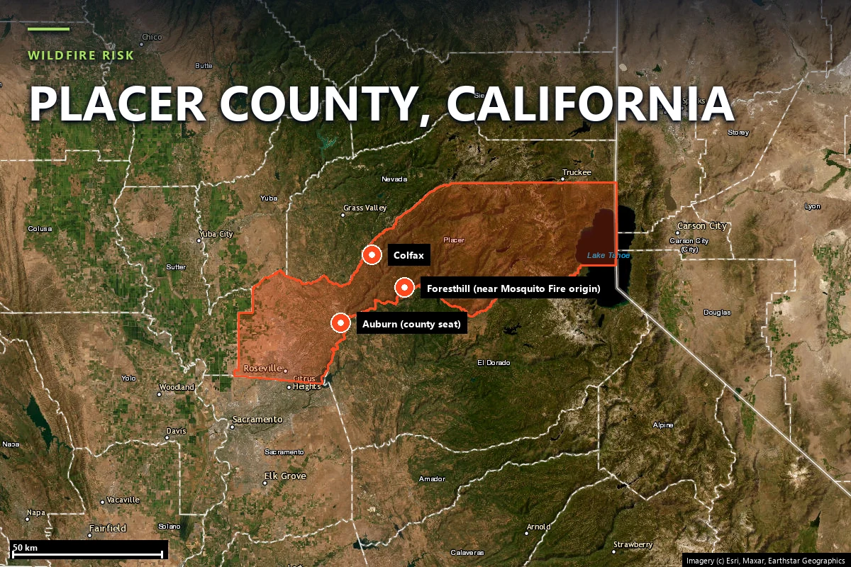
Placer County runs from the Sacramento Valley floor at Roseville up the western slope of
the Sierra Nevada to the Lake Tahoe basin. Most of its foothill and mountain population
lives along two corridors — the Interstate 80 corridor through Auburn and Colfax, and the
Foresthill Divide, the single ridge road that serves Foresthill, Michigan Bluff, and Iowa
Hill above the American River canyons. The recent record:
American Fire (2013) — 26,194 acres, burning in rugged, roadless terrain of the Tahoe National Forest about 17 miles northeast of Foresthill.
Mosquito Fire (2022) — 76,788 acres, California's largest wildfire that year. It ignited on September 6 near Mosquito Road and Oxbow Reservoir on the Middle Fork American River, just east of Foresthill, put more than 11,260 people under evacuation orders including all of Foresthill, burned for 46 days, destroyed 78 structures across Michigan Bluff, Foresthill, and Volcanoville, cost more than $180 million to suppress, and eventually crossed the ridge into El Dorado County.
The property-level fire-history layer for a Foresthill Road address independently confirms
the pattern: three separate NIFC-mapped fire perimeters have reached this exact parcel in
the last 20 years alone — Mosquito (2022), Trailhead (2016, 5,645 acres), and Robbers (2012,
2,635 acres) — on top of the 1960 Volcano Fire (42,596 acres). The fire season runs June
through October, with the highest-risk window in August and September, when fuel moisture
bottoms out on the Foresthill Divide's south- and west-facing slopes.
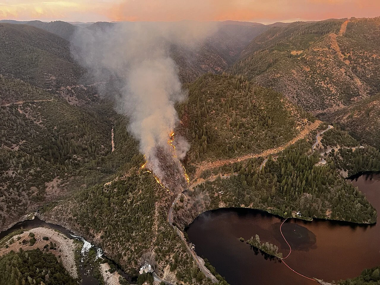
The Mosquito Fire in its early hours above Oxbow Reservoir, near the Middle Fork American
River and Foresthill — September 6, 2022. Source: United States Forest Service, Tahoe
National Forest, via
Wikimedia Commons
(public domain).
Sources: CAL FIRE Incident Archive · NIFC · USDA Forest Service, Tahoe National Forest.
Terrain & vegetation
One ridge road, two river canyons
Look at where Foresthill actually sits: on the Foresthill Divide, the
single forested ridge between the North Fork and Middle Fork American River canyons. It is
the same trap geography that recurs across Sierra foothill fire country — a ridgetop
community reachable by one road, flanked on both sides by canyons that pre-heat fuels and
channel wind uphill. The terrain layer in Satelife's Foresthill Road analysis scores
65 / 100 from elevation banding alone — the parcel sits at roughly 927
metres, squarely inside the WUI/chaparral elevation band Satelife's model treats as
elevated risk.
That is the terrain the Mosquito Fire exploited in 2022: ignition down in the Middle Fork
canyon near Oxbow Reservoir, then a run up onto the Divide toward Foresthill and Michigan
Bluff. The fuel above the canyons is mixed conifer — ponderosa pine, Douglas-fir, incense
cedar — with brush and oak woodland lower down; decades of fire suppression left dense,
ladder-fueled stands that carry fire fast once it reaches the ridge.
One data wrinkle worth naming honestly: the report's LANDFIRE vegetation layer for this
specific 100-metre buffer around the Foresthill Road parcel reads a modest
23 / 100, classifying the buffer as 85% "urban" and 15% "agricultural" fuel
model — a coarse land-cover read that misses the tree canopy visible in the same report's
own street-view imagery. That gap is exactly why Satelife layers an AI vision read on top of
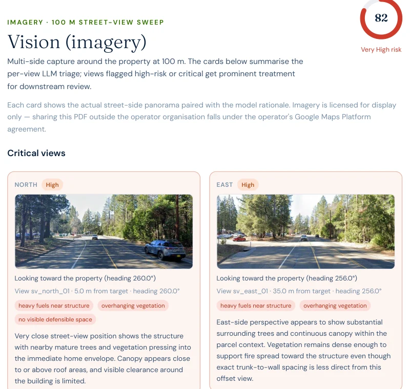
the land-cover model: the vision layer for this address scores 82 / 100,
flagging "heavy fuels near structure" and "no visible defensible space" at ground level. A
land-cover polygon can call a lot on a ridge road "urban" fuel; a photograph of the actual
trees over the roofline cannot.
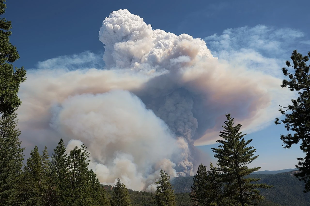
A pyrocumulonimbus cloud rises from the Mosquito Fire, September 8, 2022 — the kind of
fire-generated weather that Foresthill Divide terrain and canyon winds can produce.
Source: CAL FIRE, via
Wikimedia Commons
(public domain).
Evacuation
Hazard maps say where fire is likely. They say nothing about whether you can leave
Satelife's community-scale analysis of Foresthill builds the evacuation picture from the
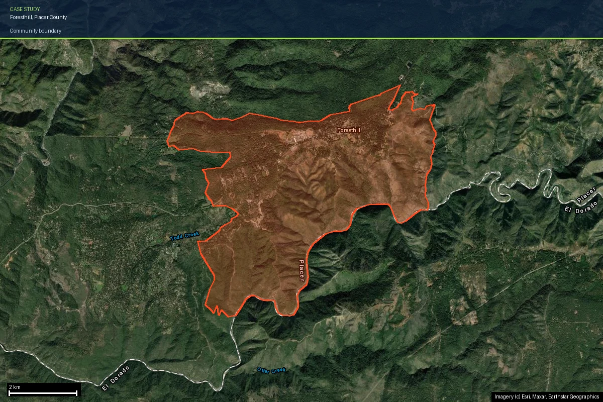
actual road graph, gridded into 332 zones across the 2,883-hectare CDP boundary. The
numbers:
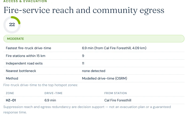
332zones analyzed across the 2,883-hectare community area
11independent exit routes to the wider road network
6.9 minmodelled fire-truck drive-time from Cal Fire Foresthill (4.1 km)
9fire stations mapped within a 15 km search radius
Unlike the ridge communities on this site's El Dorado County page, Foresthill has its own
in-town station — Cal Fire Foresthill / Foresthill Fire Station, 4.1 kilometres out — and
the route analysis found no single-point-of-failure chokepoint on any of the 11 exit
routes: "nearest bottleneck: none detected." The area-wide risk score still comes out
49/100 — Moderate, and the model resolves the whole community as one
hotspot zone with vegetation as the primary driver, rather than the several graduated
hotspots a more fragmented road network would produce.
Report excerpt — Access & Evacuation, Satelife Neighborhood Wildfire
Risk Report for Foresthill, CA (July 2026). Modelled OSRM drive-times from OSM-mapped
stations. Decision support, not an evacuation plan or a guaranteed response time.
The hazard that doesn't reset
Foresthill wasn't leveled — and that's not the same as safe
Unlike Grizzly Flats in the 2021 Caldor Fire, Foresthill itself was largely spared direct
structure loss in 2022 — the Mosquito Fire's 78 destroyed structures were concentrated in
Michigan Bluff and Volcanoville, with Foresthill mostly surviving under a mandatory
evacuation order. That is the trap: a community can go through a 76,788-acre fire next door
and conclude the danger passed it by.
It didn't. Three things didn't change:
The hazard classification. CAL FIRE's Fire Hazard Severity Zone model scores long-term hazard from climate, terrain, and fire behavior over decades. Foresthill remains Very High — 90/100 in the Satelife hazard layer, exactly as before the Mosquito Fire.
The ridge. The Foresthill Divide's single-road geography and flanking canyons are permanent.
The recurrence. This is now the third fire to reach this exact Foresthill Road parcel in a decade — Robbers (2012), Trailhead (2016), Mosquito (2022) — a pattern the property's fire-history layer scores 70/100, "High risk."
One more reason zone-level and property-level scores diverge: Satelife's community-wide
analysis of Foresthill, evaluated at the CDP's geographic centroid, reads the CAL FIRE
hazard layer at just 10/100 — while our case-study parcel a few streets
away, on the Divide's Very High-zoned edge, reads 90/100 on the identical
layer. Both numbers are correct; a fire hazard zone map isn't a single number for a town,
it's a mosaic, and only a property-level report tells you which side of that mosaic your
house sits on. The community's own fire-history and vegetation layers, evaluated area-wide,
score 90/100 and 70/100 respectively — both High to Very High — so the recurrence and fuel
story hold at every scale even where the zone boundary itself does not.
To make the county's risk concrete, we ran a full Satelife wildfire-risk report for a
property on Foresthill Road, Foresthill — inside the community, on the
Divide, in the Very High zone. The composite score:
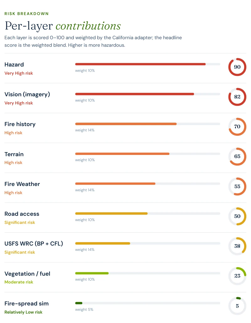
56 / 100 — High tier (88% confidence), built from ten independently-scored
data layers rather than one hazard polygon.
Report excerpt — Per-layer contributions, Satelife Wildfire Risk Report,
Foresthill Road, Foresthill, CA 95631 (July 2026). Composite 56/100, High tier.
What drives the score:
Hazard zone: 90/100. The parcel sits squarely in CAL FIRE's Very High Fire Hazard Severity Zone (State Responsibility Area).
AI vision analysis: 82/100 — Very High. The model reads street-level imagery of the actual property: a tree-dense setting with continuous canopy over the frontage and side yards, limited visible clearance around the structure, and tree limbs extending near or over the roofline.
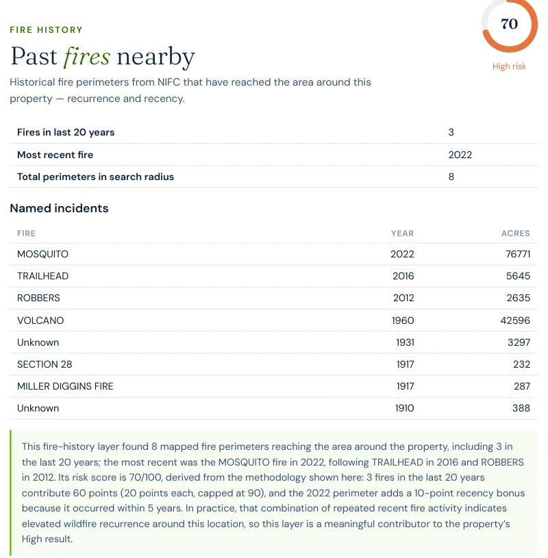
Fire history: 70/100 — and it names the Mosquito. The layer finds 3 fires within 20 years, most recent 2022: MOSQUITO (76,771 acres) heads the list, followed by TRAILHEAD (2016) and ROBBERS (2012), on top of 8 total mapped perimeters reaching back to 1910.
Terrain: 65/100. Elevation banding alone — 927 metres, inside the WUI/chaparral elevation band — puts a thumb on the scale before vegetation is even counted.
Report excerpt — Fire history: the layer names the Mosquito Fire (2022,
76,771 acres) as the most recent perimeter reaching this parcel, on top of Trailhead
(2016) and Robbers (2012).
Report excerpt — Vision sweep by direction: north and east views both
rate High, with findings like "heavy fuels near structure" and "no visible defensible
space."
The FHSZ polygon says "Very High" for every parcel on the Foresthill Divide equally. The
report says this house has canopy over the roofline and no visible clearance at
the fence line — and which three actions, in order, change that.
The report pairs the score with a prioritized mitigation plan for this exact parcel:
establish an ember-resistant Zone 0 in the first five feet, harden the roof and screen vents
against ember intrusion, and maintain thirty feet of lean, clean and green space. Under
SB 1060-era rules, completing and documenting that work is not just safety advice — it is
insurance evidence.
Insurance & real estate
The insurance squeeze in Placer County
Placer County homeowners feel all of the above through their insurance bill — when they can
get one. Since 2022 the pattern across the county's foothill and Divide communities has been
carrier non-renewals followed by migration to the California FAIR Plan, the
state's insurer of last resort, which surpassed 400,000 policies statewide in 2024 —
roughly double its 2020 count. FAIR Plan coverage is more expensive and thinner than the
policies it replaces.
The regulatory response matters here: SB 1060 (in force 2025) requires
carriers that use wildfire risk models to account for property- and community-level
mitigation — defensible space, home hardening, community fuel breaks — rather than pricing
on hazard zone alone. Together with the Safer from Wildfires framework, that creates a
financial reason to prove, with evidence, what your specific parcel looks like. A zone map
can't do that. An address-level report can.
For buyers and sellers, California Civil Code §1103 requires Natural Hazard Disclosure at
the point of sale — and as insurance availability tightens, fire-zone status becomes a
closing-risk variable rather than a paperwork item. A buyer who cannot bind insurance
cannot close. See
California wildfire insurance
and
California real estate wildfire risk.
Sources: California Department of Insurance · California FAIR Plan · SB 1060 text.
Risk reduction
What Placer County homeowners can actually do
Placer County's defensible-space ordinance requires 100 feet of clearance around structures
(Zones 1 and 2), plus the state-mandated ember-resistant Zone 0 (0–5 ft) added under
Assembly Bill 3074. The county and CAL FIRE co-fund a low-cost residential chipper program
to make compliance affordable. Locally, the Foresthill/Iowa Hill Fire Safe
Council runs the community's Firewise programs, and the county-led
Foresthill Divide Community Protection Project is building a
138,000-acre network of fuel breaks across state, federal, and private land aimed
specifically at protecting Foresthill, Baker Ranch, Iowa Hill, and Michigan Bluff — including
a $1.5 million federal grant to assess wildfire risk across 50,000 acres of the Baker
Ranch/Shirttail Canyon area.
Annual review is the rule, not the exception: vegetation regrows every season, and a parcel
that passed inspection in 2024 is not necessarily compliant in 2026.
Set next to this site's El Dorado County page,
the two Sierra foothill communities share the same ridge-and-canyon trap geography and a
recent megafire apiece — but their access pictures are opposites. Grizzly Flats' fastest
modelled fire-truck response is 32 minutes from a station 22.8 kilometres out, with a
roughly 20-metre single-point-of-failure chokepoint on its exit network. Foresthill's
fastest response is 6.9 minutes from an in-town station 4.1 kilometres out,
and the same route analysis found no bottleneck at all across its 11 exits.
The hazard zone, the fuel, and the fire history read similarly Very High on both pages — the
variable that actually separates them is whether the community has its own fire station on
the ridge.
Coverage
ZIP codes we cover in Placer County
Satelife runs address-level wildfire reports across every ZIP code in Placer County.
The ZIPs below are the high Fire Hazard Severity Zone, Wildland-Urban Interface
communities we are asked about most. One caveat that is the whole point of what we
do: the risk score is computed for your parcel, not the ZIP, so two
homes on the same street can land in different tiers. Find your area, then
run your address.
ZIP code
Community
Why it is on the map
95631
Foresthill
Mosquito Fire (2022); Foresthill Road case study
95713
Colfax
I-80 ridge WUI between the American and Bear rivers
95722
Meadow Vista
Foothill WUI below the Foresthill Divide
95602
Auburn
North Auburn and American River canyon WUI
95736
Weimar
Ridge WUI along the I-80 canyon country
95714
Dutch Flat
Sierra forest WUI, historic canyon town
95701
Alta
Upper I-80 forest WUI
96145
Tahoe City
West-shore Tahoe basin forest WUI
ZIP areas per USPS; Wildland-Urban Interface and Fire Hazard Severity Zone framing per CAL FIRE.
Frequently asked questions about Placer County wildfire risk
Is Placer County a high wildfire risk area?
Yes, above the valley floor. The foothill and mountain communities along the Interstate 80 and Foresthill Road corridors — Colfax, Foresthill, Michigan Bluff, Iowa Hill — sit in CAL FIRE High or Very High Fire Hazard Severity Zones. The 2022 Mosquito Fire, California’s largest fire that year, burned 76,788 acres starting near Foresthill.
What was the largest wildfire in Placer County?
The 2022 Mosquito Fire — 76,788 acres. It ignited near Oxbow Reservoir on the Middle Fork American River, east of Foresthill, on September 6, 2022, forced the evacuation of Foresthill and neighboring communities, burned for 46 days, destroyed 78 structures across Michigan Bluff, Foresthill, and Volcanoville, and crossed the ridge into El Dorado County before full containment on October 22.
Is it safe to live in Foresthill after the Mosquito Fire?
The hazard classification did not change: Foresthill remains in a CAL FIRE Very High Fire Hazard Severity Zone, and a current Satelife hazard layer for a Foresthill Road address still reads 90/100. The Mosquito Fire’s ignition point at Oxbow Reservoir sits a few miles from town, and the fire history layer for this exact address now lists three fires within 20 years — Mosquito (2022), Trailhead (2016), and Robbers (2012) — evidence of recurring fire activity on the Foresthill Divide, not a one-off event.
How do I check the fire hazard zone for my Placer County address?
Use the CAL FIRE FHSZ viewer for the official Moderate / High / Very High zone classification. For property-level detail — terrain, fuels, fire history, evacuation constraints, and an AI read of your actual parcel imagery — run a Satelife address-level report.
Can wildfire mitigation lower my insurance premium in Placer County?
Yes. Under SB 1060 (in force 2025), California carriers that use wildfire risk models must account for property- and community-level mitigation. Documented defensible space and home hardening — the kind of evidence a Satelife report captures — feeds directly into that discount pathway, alongside the Safer from Wildfires framework.
Scores and evacuation figures on this page are drawn from Satelife wildfire-risk reports for
Foresthill, CA generated in July 2026 (property report, Foresthill Road; neighborhood
analysis, Foresthill CDP). Satelife reports are informational decision support — not a
substitute for official evacuation orders, CAL FIRE hazard determinations, or an insurer's
underwriting judgement.
What does your parcel look like, layer by layer?
If you own, are buying, or are rebuilding in Placer County — Foresthill, Auburn, Colfax, or anywhere on the Foresthill Divide — get the address-level answer: PDF, ten-layer score, and a prioritized mitigation plan.