Wildfire risk in Randall County: Canyon and a moderate score built from stacked pressure
Our Satelife report for Hunsley Road in Canyon returns
39.66 / 100 — Moderate, with elevated climate, terrain,
vegetation and hazard layers all pushing upward at once. The unusual part is
that the federal flame-length model still returns 0.0%
above both four feet and eight feet at the parcel.
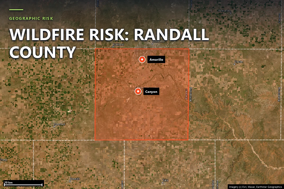
South of Amarillo, the High Plains break toward Palo Duro Canyon
Randall County is not the same Panhandle fire story as Hutchinson County, but it belongs to the same
wind regime. Canyon, the southern edge of Amarillo and the county’s rural settlements sit on open High
Plains ground broken by draws, canyon rims and the enormous relief of Palo Duro. The exposure is less
about one single famous burn scar than about what those winds do when grass, brush and developed edges
sit against each other in late winter, spring and drought summer windows.
That is why the Hunsley Road parcel scores the way it does. The report is reading a place with broad
open-country weather pressure, real vegetation around the structure and enough relief to matter, even
though the exact flame-length exceedance raster at the parcel is quiet.
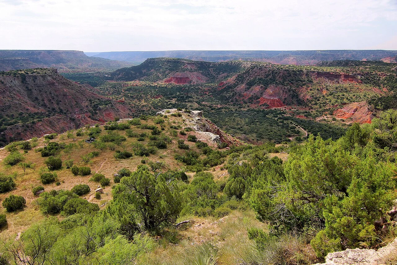
Palo Duro Canyon from the CCC overlook — the relief feature that makes Randall County more than a
flat prairie story. Source:
Wikimedia Commons
(CC BY 4.0).
Sources: regional landscape context from Randall County / Canyon geography; parcel and community
figures from Satelife reports generated 25 July 2026.
Terrain & fuel
A moderate Texas score without an extreme flame-length reading
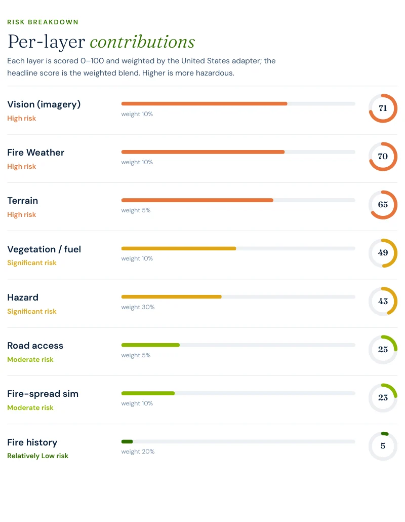
Randall County is the most layered of the new Texas pages. The Hunsley Road parcel scores
71 on AI vision, 69.9 on climate, 65 on terrain,
49.1 on vegetation, 42.9 on hazard, 25 on road access
and 22.9 on fire-spread simulation. No one of those numbers looks like Hutchinson
County. Together they are enough to land the parcel at 39.66 Moderate.
This is exactly the kind of page where the per-layer breakdown matters more than the tier label. The
parcel is not severe in the same way as a grass-front town, but it is also not quietly suburban. The
risk is cumulative.
Evacuation
More exits than Fritch, fewer than Bulverde, and still a real community load
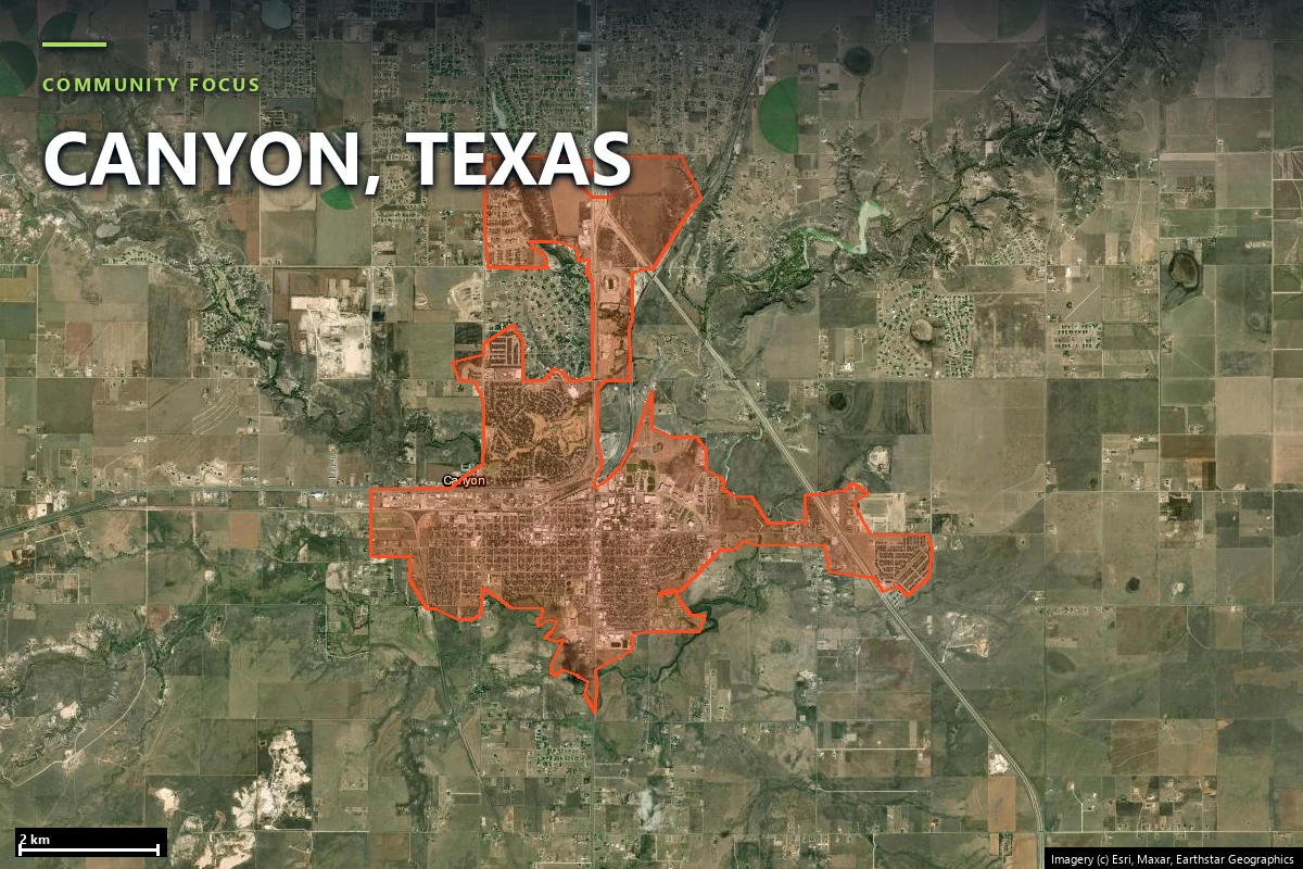
The community rerun gives a usable middle-ground road picture: stronger than the tightest Texas pages,
weaker than the best redundant ones.
194structures in the analyzed community footprint
69independent exits from the analyzed area
2.81structures per exit route
4OSM-mapped fire stations within the search radius
2.9 minfastest modelled engine time
6.3–6.9 minmodelled hotspot-zone drive-times
The rerun did not return a non-null single-point-failure width, so this page does not fabricate one.
What it can say cleanly is that Randall County’s Canyon footprint has meaningful but not extreme road
redundancy, and that the parcel-level access layer of 25 / 100 is therefore not an
accident. Access is a real contributor here.
Report excerpt — Road access: suppression reach & egress, Satelife Wildfire
Risk Report, Hunsley Road, Canyon TX 79015 (July 2026). Drive-times are modelled on the public road
graph and OSM-mapped stations; decision support, not an evacuation plan.
Hazard framing
Moderate because many layers are elevated at once, not because one model is maxed out
Randall County is the clearest demonstration in this batch that a Texas Moderate tier can arrive
without a dramatic flame-length result. The 0.0% exceedance values are real and should not be talked
around. The report is still Moderate because almost every other layer is elevated above the low twenties.
39.66property composite score — Moderate tier
71AI vision layer — the property’s highest score
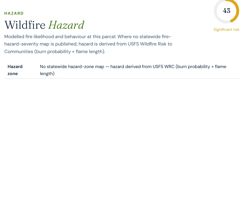
42.9hazard layer, backfilled from USFS WRC
0.0%probability of flames over 4 ft and over 8 ft
That combination is analytically useful. It says the parcel is exposed through weather, open-country
setting, vegetation and road geometry in a way that a single thresholded fire-behavior number does not
fully summarize. In a Texas state with no official hazard map, this is exactly why the per-layer readout
matters.
Randall County is not the Panhandle’s most explosive page. It is one of its clearest “read the stack,
not the headline model” pages.
Case study
One address on Hunsley Road, scored today
We ran a full Satelife wildfire-risk report for a property on Hunsley Road, Canyon TX
79015. The composite returns 39.66 / 100 — Moderate tier, at
0.82 confidence.
Report excerpt — Per-layer contributions, Satelife Wildfire Risk Report, Hunsley
Road, Canyon TX 79015 (25 July 2026). Composite 39.66/100, Moderate tier, scored under the United
States (usa_generic) adapter.
What drives the score:
Vision: 71 / 100. The imagery read sees meaningful structure-adjacent exposure.
Climate: 69.9 / 100 and terrain 65 / 100. The open-country weather and relief context are both strong contributors.
Vegetation: 49.1 / 100. Higher than any of the Hill Country additions in this batch.
Hazard: 42.9 / 100 and road access 25 / 100. These two keep the parcel solidly in Moderate territory.
Fire-spread simulation: 22.9 / 100. Not dominant, but high enough to reinforce the rest of the stack.
The Hunsley Road parcel is what a Moderate Texas score looks like when no single layer is catastrophic
and almost all of them are meaningfully elevated.
The mitigation plan follows that reading: audit defensible space annually before fire season
and verify access-route width and gate clearance.
Insurance & real estate
In Randall County the useful document is the one that explains why Moderate means Moderate
A Canyon-area buyer does not have the benefit of an official Texas wildfire zone map, and a Moderate
headline without layer context can be easy to misread. That makes the report more useful than a single
score. It shows whether the parcel is moderate because of one severe driver or because multiple layers
are each somewhat elevated.
Texas also offers no statewide mitigation-discount mandate. If a carrier responds favorably to annual
defensible-space maintenance, access clearance or home hardening, it is doing so as an underwriting
choice rather than under a published statutory schedule. If admitted coverage fails, the backstop is
the Texas FAIR Plan Association, available after at least two carrier declines.
For Randall County property, the report is useful precisely because it translates a non-obvious moderate
score into the layers an insurer, buyer or owner can actually act on.
Sources: Texas Department of Insurance · Texas FAIR Plan Association · Texas Property Code §5.008.
Risk reduction
What Randall County homeowners can actually do
Randall County’s mitigation posture starts with the same basics as the Panhandle generally: keep Zone 0
free of combustibles, control cured grasses and fine fuels near the structure, and maintain engine-usable
access before fire season. The difference from Fritch is that Randall’s case-study parcel is not being
driven by one overwhelming grass-fire intensity number.
Compare it directly with
Hutchinson County.
Canyon scores 39.66 / 100 Moderate with 0.0% modeled four-foot flame
exceedance and 2.81 structures per exit. Fritch scores 59 / 100 High
with 71.0% four-foot exceedance and one station serving a town that has already burned
twice in ten years. Same region, different problem class.
Coverage
ZIP codes we cover in Randall County
Satelife runs address-level wildfire reports across every ZIP code in Randall County.
The ZIPs below are the High Plains edge, canyon terrain and Wildland-Urban Interface
communities we are asked about most. One caveat that is the whole point of what we
do: the risk score is computed for your parcel, not the ZIP, so two
homes on the same street can land in different tiers. Find your area, then
run your address.
ZIP code
Community
Why it is on the map
79015
Canyon
Hunsley Road case study and the county’s main Palo Duro edge community
79118
Amarillo south side
South-county growth front extending into Randall County grass and draw terrain
79042
Happy
Rural south-county agricultural and grass fuel landscape
79091
Umbarger
Low-density High Plains settlement south of Canyon
ZIP areas per USPS. Texas publishes no statewide fire hazard severity zone map; Wildland-Urban Interface framing per Texas A&M Forest Service.
Frequently asked questions about Randall County wildfire risk
Is Randall County a high wildfire risk county?
Our published Canyon parcel is not high, but it is more elevated than the other new Texas additions. The Hunsley Road report returns 39.66 / 100 in the Moderate tier, with hazard 42.9, vegetation 49.1, climate 69.9 and terrain 65. What is unusual is that the federal model still returns 0.0% probability of flames over four feet and over eight feet. Randall County’s moderate score comes from layered landscape pressure, not from one extreme flame-length result.
Why can a Canyon parcel score Moderate if flame-length exceedance is 0.0%?
Because the Satelife composite is broader than that single model. At this parcel, AI vision is 71, climate 69.9, terrain 65, vegetation 49.1, hazard 42.9, road access 25 and fire-spread simulation 22.9. Together those layers describe a place that is meaningfully exposed even though the WRC flame-length raster is quiet at the exact point sampled.
How many exits does the Canyon community analysis have?
The rerun community analysis finds 69 exits serving 194 structures, or 2.81 structures per exit, with four mapped stations in range and a fastest modeled engine time of 2.9 minutes. The run did not return a non-null single-point-failure width, so this page does not invent one.
What part of Randall County does this page cover best?
The highest-signal WUI areas are Canyon, the south side of Amarillo in ZIP 79118, Happy and Umbarger — places where grass, draws, canyon rims and expanding residential footprints meet. The page is built from a Canyon property and community run, but the landscape logic carries across the county’s southern High Plains edge.
What mitigation did the Hunsley Road report recommend?
Audit defensible space annually before fire season and verify access-route width and gate clearance. That pairing fits the profile: several moderately elevated landscape layers plus a 25 / 100 road-access score.
Scores and evacuation figures on this page are drawn from Satelife wildfire-risk reports generated on
25 July 2026 under the United States (usa_generic) adapter: a property report for Hunsley
Road, Canyon TX 79015, and the rerun community analysis 72f33eff-bb38-48e6-a3d3-3cb435f3a96c for the
Canyon-area case study. Texas publishes no statewide fire-hazard-severity map, so the hazard layer is
backfilled from the USFS Wildfire Risk to Communities model. Where the rerun did not return a non-null
value, this page omits the claim rather than guessing. Drive-times are modelled on OSM-mapped stations
and the current road graph. Satelife reports are informational decision support — not a substitute for
official evacuation orders, state or federal hazard determinations, or an insurer’s underwriting
judgment.
What does your Randall County parcel look like, layer by layer?
If you own or are buying in Randall County — Canyon, the south side of Amarillo, Happy or Umbarger — get the address-level answer: PDF, per-layer score, and a prioritized mitigation plan.