Wildfire risk in Ventura County: the county where California's largest modern wildfire began
The 2017 Thomas Fire ignited north of Santa Paula, ran to the coast at
Ventura, and surrounded the entire Ojai Valley — 281,893 acres, 1,063
structures, and, at the time, the largest wildfire in modern California
history. A current Satelife property report for a Gridley Road address on
the Ojai foothills reads 55.0/100, High tier, and names the Thomas Fire
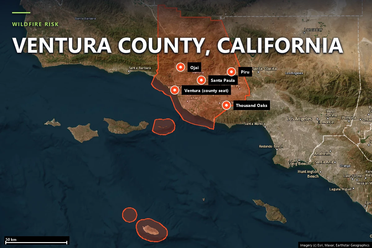
directly. This page maps Ventura County's wildfire risk with satellite data
and two real Satelife reports run from inside Ojai in July 2026.
Where the Thomas Fire started — and why the county keeps burning
Ventura County runs from the Pacific coast at Ventura and Oxnard up through the
Santa Clara River valley to the Topatopa and Santa Ynez foothills around Ojai,
and east across the Santa Susana and Santa Monica Mountains toward Thousand Oaks.
Its wildfire risk concentrates in those foothill and Wildland-Urban Interface belts,
and the record is among the most severe in the state:
Thomas Fire (December 2017) — 281,893 acres across Ventura and Santa Barbara counties, 1,063 structures destroyed, one firefighter killed. Ignited near Steckel Park north of Santa Paula on December 4, ran to the coast and destroyed 500+ homes in Ventura the first night, then surrounded the Ojai Valley. It became the largest recorded California wildfire at the time — and its burn scar produced the deadly Montecito debris flow a month later.
Woolsey Fire (November 2018) — 96,949 acres across Ventura and Los Angeles counties, ~1,643 structures destroyed, 3 deaths. Ignited near the former Santa Susana Field Laboratory on the Ventura County line and ran south through the Santa Monica Mountains to Malibu.
Maria Fire (October 2019) — 9,999 acres on South Mountain between Santa Paula and Somis, driven by Santa Ana winds; roughly 7,500 residents evacuated. Earlier, the 2013 Springs Fire burned about 24,000 acres of the Camarillo and Newbury Park interface.
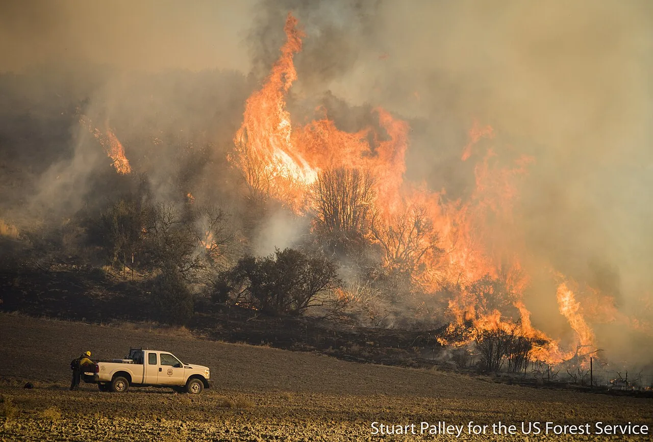
The Thomas Fire burning through chaparral during firing operations in the Los Padres National
Forest, December 21, 2017. US Forest Service photo by Stuart Palley, via
Wikimedia Commons
(public domain).
Unlike the Sierra foothill counties, where fire season peaks in summer, Ventura
County's most destructive fires cluster in the Santa Ana wind season — roughly
September through January — when offshore winds push hot, dry air down through
the canyons toward the coast at exactly the moment humidity bottoms out. The
Thomas Fire ran hardest in mid-December.
Sources: CAL FIRE Incident Archive · NIFC · Ventura County Fire Department.
Terrain & vegetation
A green valley floor ringed by flammable foothills
Ojai sits at roughly 240 metres in a valley enclosed on almost every side by the
Topatopa and Santa Ynez foothills — chaparral and oak woodland that dry to tinder
by autumn. The valley floor itself reads very differently from the ridgelines: a
Satelife property report for a Gridley Road address on the north edge scores the
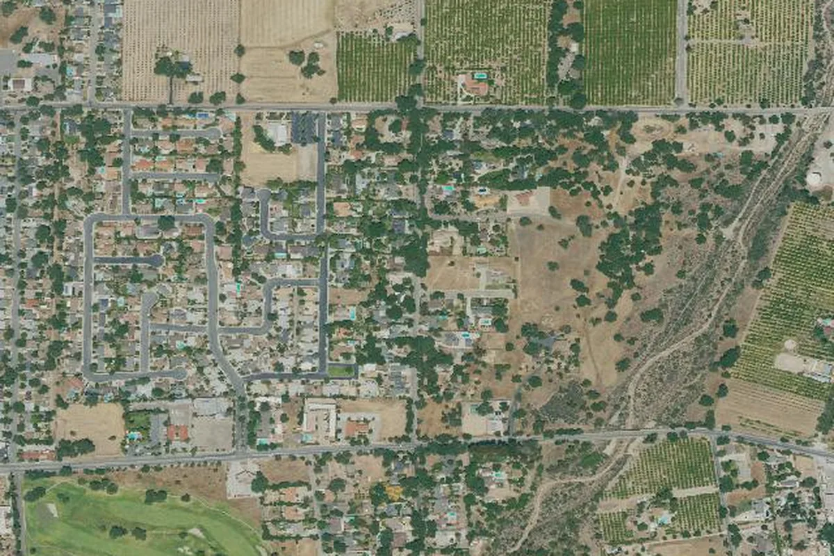
vegetation layer a low 24.6 / 100, because the parcel's immediate
100-metre surroundings are mostly urban and agricultural land cover — orchards and
landscaped lots — rather than open chaparral.
That low vegetation reading sits next to a Very High hazard
classification and a fire-history score of 90/100, which is exactly the point: the
fuel immediately around a house on the valley floor can look benign while the
terrain layer (elevation banding puts this parcel in the 100–500 m foothill band,
scored 40/100) and the surrounding ridge fuels carry the real long-term hazard.
Santa Ana winds compound the geography — offshore flow accelerates over the passes
and drives embers down onto the valley from the burning slopes above.
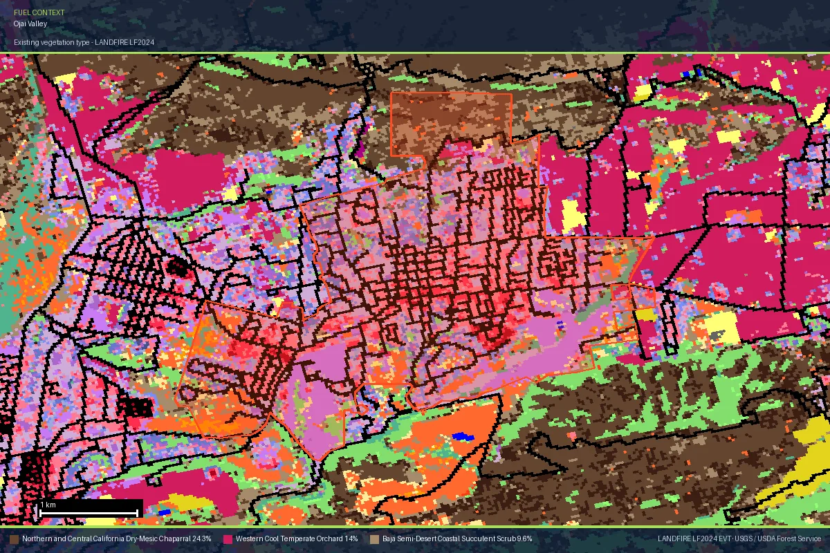
LANDFIRE LF2024 vegetation map of the Ojai Valley — the same public dataset behind the
vegetation layer in Satelife reports. The town grid and orchards (~14% of the frame) sit on
the valley floor; the brown ring around them is the dry-mesic chaparral (~24%) that carried
the Thomas Fire. Data: LANDFIRE EVT · USGS / USDA Forest Service.
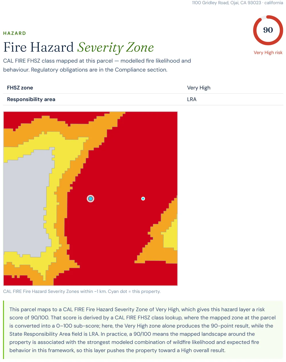
Report excerpt — Fire Hazard Severity Zone: the Gridley Road parcel
sits in CAL FIRE's Very High zone (Local Responsibility Area). Satelife Wildfire Risk
Report, Ojai, CA (July 2026).
Evacuation
Fast fire crews, but a valley with few ways out
Satelife's community-scale analysis of Ojai builds the picture from the actual road
graph — 471 hundred-metre zones across roughly 1,955 hectares of valley and foothill,
scored at 34.8 / 100 — Moderate area-wide, with the risk concentrated
in the recurrent-burn corridors along the northern foothills rather than spread evenly
across the valley.
471hundred-metre zones in the analyzed community area
16independent exit routes to the wider road network
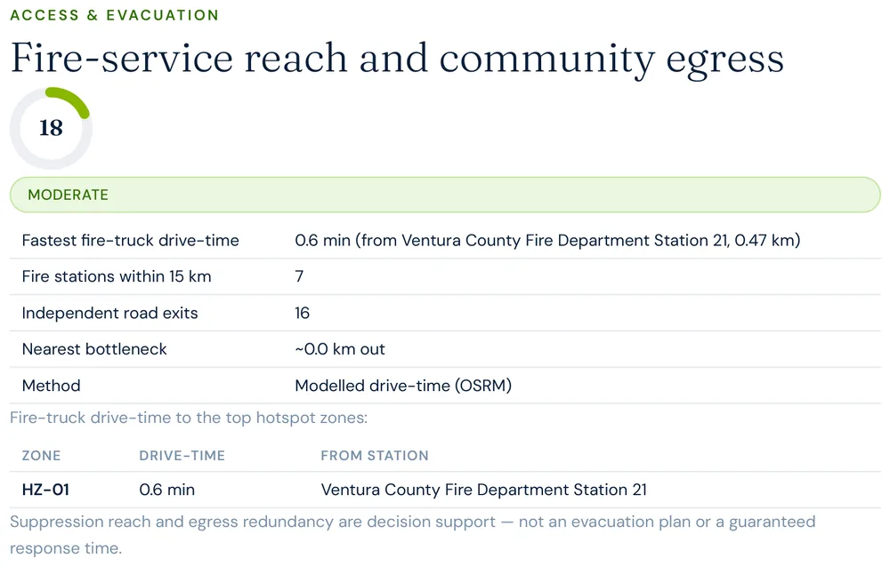
0.6 minmodelled fire-truck drive-time from the nearest mapped station (0.47 km)
7fire stations mapped within 15 km
Fire-service reach here is genuinely strong — Ventura County Fire Department Station 21
sits 0.47 km from the community centroid, a modelled 0.6-minute drive-time, with seven
stations mapped within 15 km. What the geography flags instead is the same constraint
that made the December 2017 evacuation so tense: the Ojai Valley funnels onto a handful
of arteries — State Route 33 north and State Route 150 east and west — and when the
Thomas Fire surrounded the valley, those few routes were carrying the whole town at once.
A strong engine response does not change how many roads lead out.
Report excerpt — Access & Evacuation, Satelife Neighborhood Wildfire
Risk Report for Ojai, CA (July 2026). Modelled OSRM drive-times from OSM-mapped stations.
Decision support, not an evacuation plan.
The post-fire cycle
A low vegetation score is a snapshot, not a resolved risk
The Ojai foothills have had most of a decade to regrow since the Thomas Fire, and it is
easy to read the green valley and the low current vegetation reading as reduced risk.
Right now, Satelife's community-scale vegetation layer for the Ojai area reads around
23 / 100, comparatively low.
That has not moved the things that matter more over the long run:
The hazard classification. CAL FIRE's Fire Hazard Severity Zone model, which scores long-term hazard from climate, terrain, and fire behavior rather than this season's fuel load, reads Very High at the Gridley Road parcel — 90/100 in Satelife's property-level hazard layer.
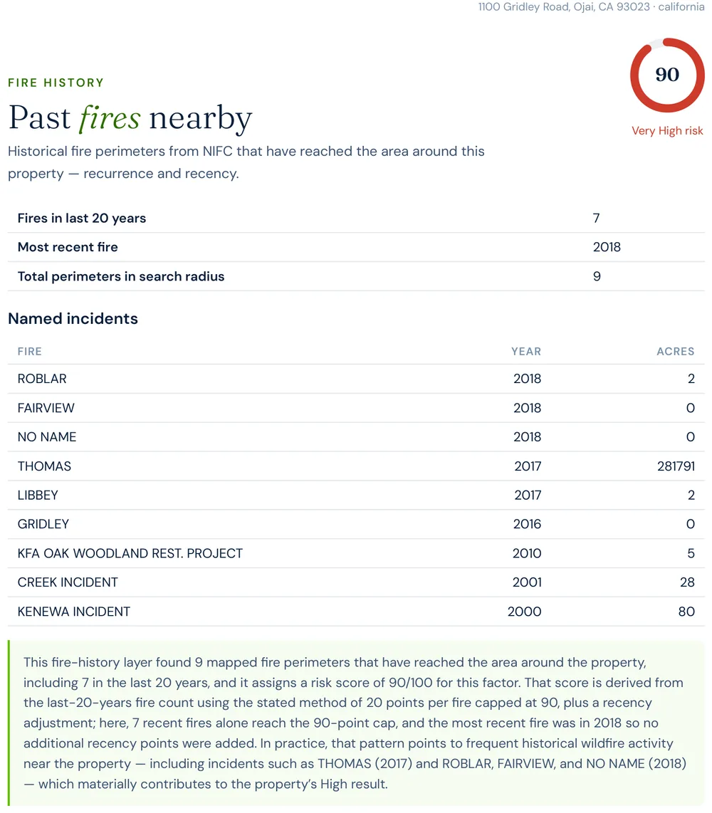
The fire-history signal. Satelife's property fire-history layer scores 90/100 — seven mapped perimeters have reached this parcel in the last twenty years, headed by the Thomas Fire (2017).
The terrain and wind exposure. The Topatopa and Santa Ynez foothills and the Santa Ana wind corridor are permanent; they do not reset when the chaparral does.
Chaparral is a fast fuel — a slope that burned in 2017 can be flammable again well within
a decade. A low vegetation reading on the Ojai Valley floor is a snapshot of one parcel's
immediate surroundings, not a verdict on the ridgelines above it.
To make the county's risk concrete, we ran a full Satelife wildfire-risk report for a
property on Gridley Road, Ojai — on the foothill edge the Thomas Fire
pressed against. The composite score: 55.0 / 100 — High tier
(86% confidence), built from ten independently-scored data layers rather than one hazard
polygon.
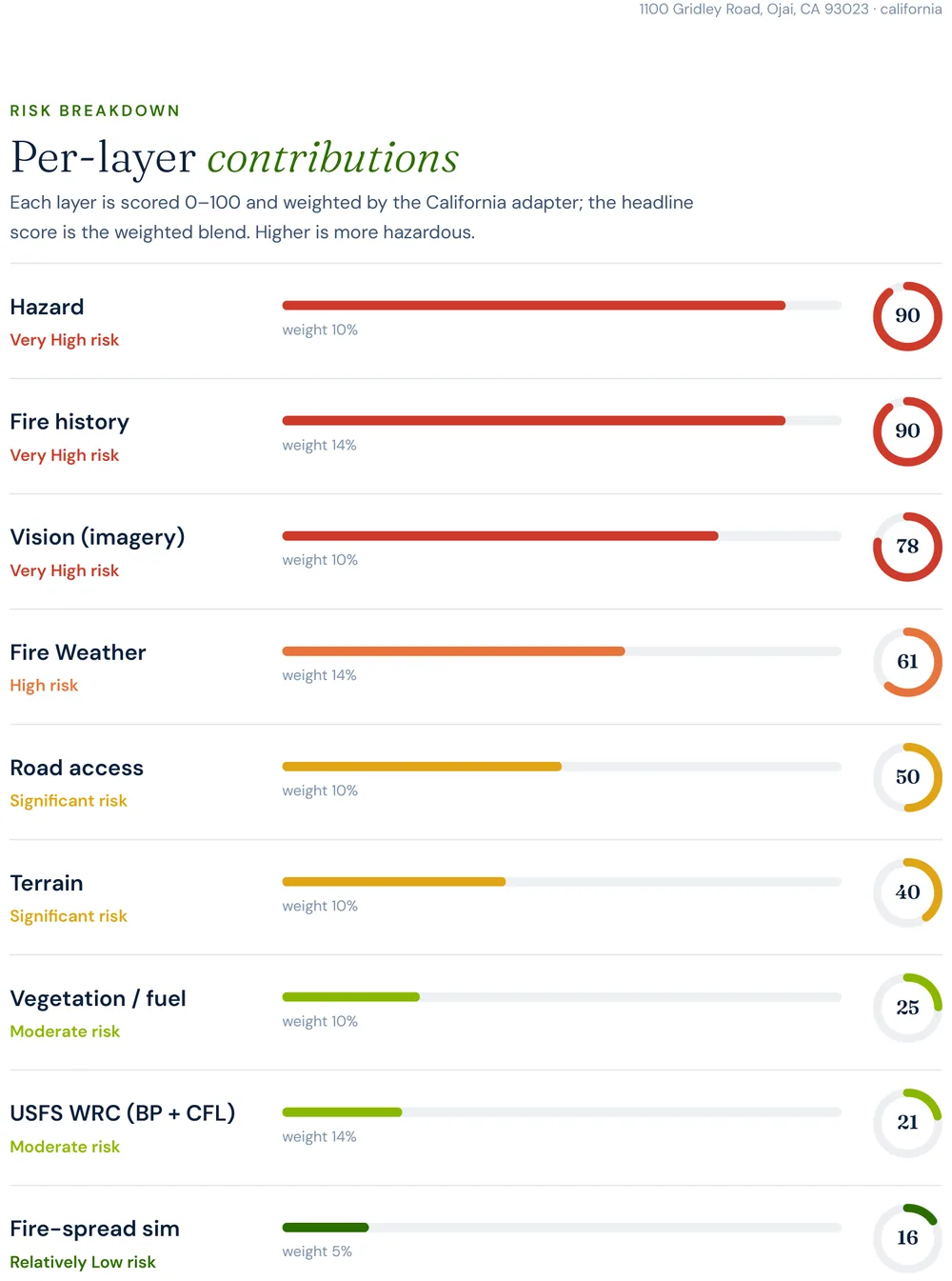
Report excerpt — Per-layer contributions, Satelife Wildfire Risk Report,
Gridley Road, Ojai, CA 93023 (July 2026). Composite 55.0/100, High tier.
What drives the score:
Fire history: 90/100 — and it names the Thomas Fire. The layer finds 7 fires within 20 years at this parcel, out of 9 mapped perimeters total. THOMAS (2017, 281,791 acres) heads the list, followed by LIBBEY (2017) and GRIDLEY (2016), with older perimeters back to 2000.
Hazard zone: 90/100. The parcel sits squarely in CAL FIRE's Very High Fire Hazard Severity Zone (Local Responsibility Area).
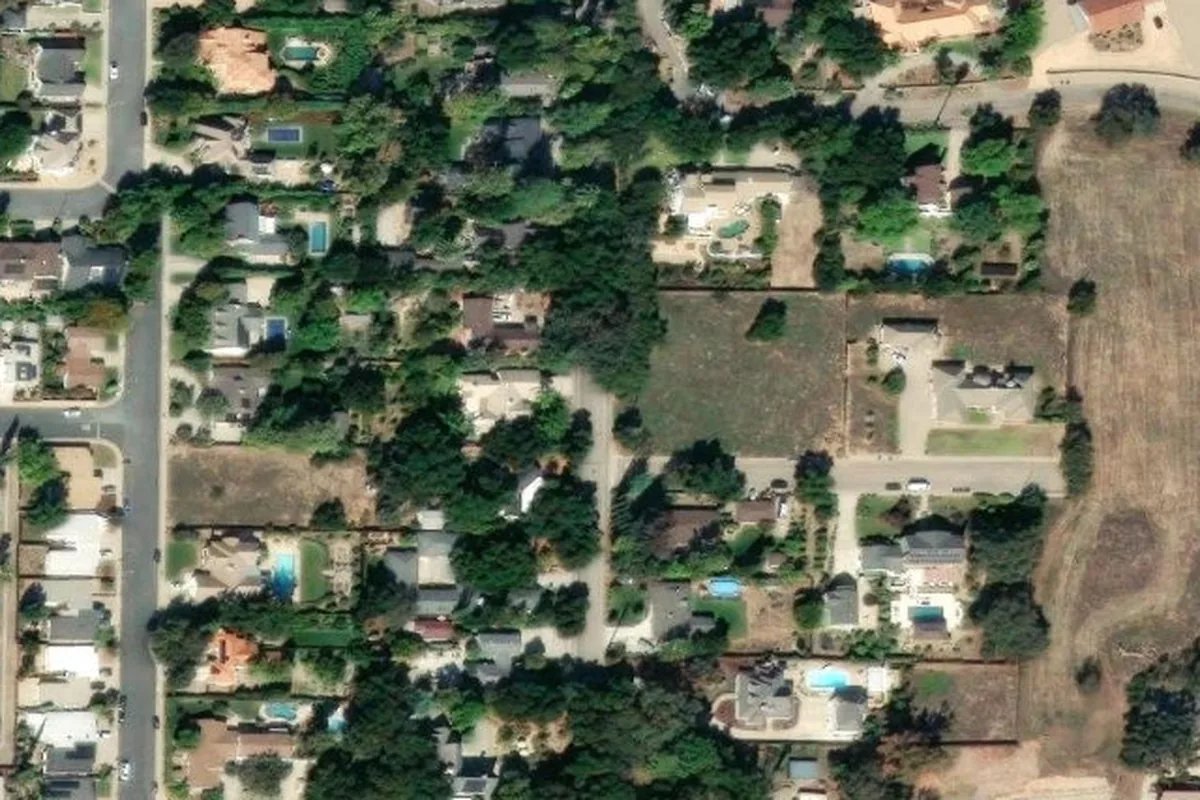
AI vision analysis: 78/100 — High. The model reads street-level imagery from all four sides: the north, south, and west views all rate High, flagging heavy fuels near the structure and overhanging vegetation with limited open defensible space; the east view rates Medium.
Fire behavior: USFS Wildfire Risk to Communities data puts the probability of flame lengths over four feet at this exact location at 0%, and the fire-spread sub-layer scores a low 15.5 — the valley-floor fuels are genuinely benign here. It is the hazard zone, the repeated fire history, and what the imagery shows at the structure that push this parcel into the High tier.
Report excerpt — Fire history: the layer names the Thomas Fire (2017) as
the largest perimeter reaching this parcel.
Report excerpt — Vision sweep by direction: three of four critical views
rate High, with findings like "heavy fuels near structure" and "overhanging vegetation".
The FHSZ polygon says "Very High" for every parcel on this foothill edge equally. The report
says this house has overhanging canopy on three sides and no open defensible space to
the south — and which three actions, in order, change that.
The report pairs the score with a prioritized mitigation plan for this exact parcel:
establish an ember-resistant Zone 0 in the first five feet, harden the roof and screen vents
against ember intrusion, and maintain thirty feet of lean, clean and green space. Under
SB 1060-era rules, completing and documenting that work is not just safety advice — it is
insurance evidence.
Insurance & real estate
The insurance squeeze in Ventura County
County homeowners feel all of the above through their insurance bill — when they can get
one. Foothill WUI communities from Ojai to Thousand Oaks have seen a steady pattern of
carrier non-renewals followed by migration to the California FAIR Plan, the
state's insurer of last resort, which surpassed 400,000 policies statewide in 2024 — roughly
double its 2020 count. FAIR Plan coverage is more expensive and thinner than the policies it
replaces.
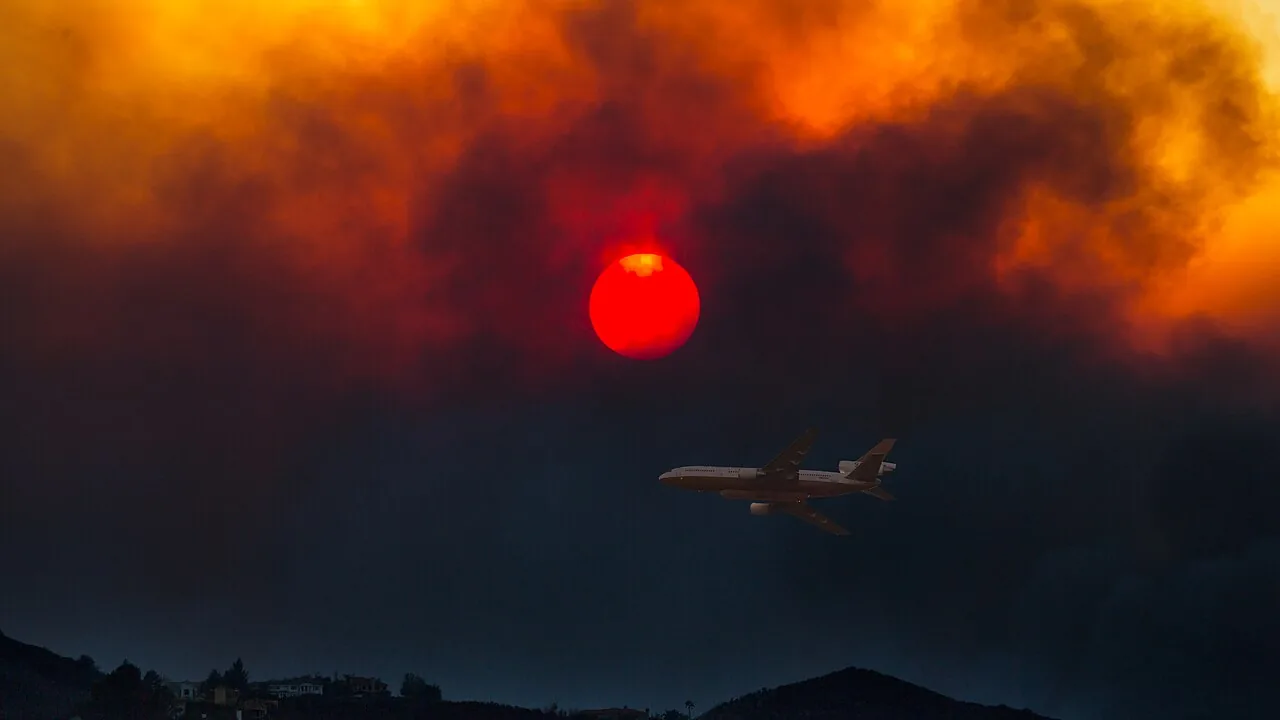
A DC-10 air tanker under a smoke-reddened sun over the Woolsey Fire, November 2018 — the
second megafire to hit the county's insurance market in twelve months. US Forest Service
photo by Peter Buschmann, via
Wikimedia Commons
(public domain).
The regulatory response matters here: SB 1060 (in force 2025) requires
carriers that use wildfire risk models to account for property- and community-level
mitigation — defensible space, home hardening, community fuel breaks — rather than pricing
on hazard zone alone. Together with the Safer from Wildfires framework, that creates a
financial reason to prove, with evidence, what your specific parcel looks like. A zone map
can't do that. An address-level report can.
For buyers and sellers, California Civil Code §1103 requires Natural Hazard Disclosure at
the point of sale — and as insurance availability tightens, fire-zone status becomes a
closing-risk variable rather than a paperwork item. A buyer who cannot bind insurance cannot
close. See
California wildfire insurance
and
California real estate wildfire risk.
Sources: California Department of Insurance · California FAIR Plan · SB 1060 text.
Risk reduction
What Ventura County homeowners can actually do
CAL FIRE's defensible-space framework defines three zones: Zone 0 (0–5 ft,
ember-resistant, no combustibles), Zone 1 (5–30 ft, lean-clean-green), and Zone 2
(30–100 ft, reduced fuel). Documented compliance is what underwriters and the SB 1060
discount process accept as evidence. Locally, the Ventura County Fire Department
runs suppression response and defensible-space inspections — the department a Satelife report
for Ojai actually models drive-times from — and Fire Safe Councils across the Ojai Valley and
Conejo Valley coordinate fuel-reduction work in the recurrent-burn corridors.
Annual review is the rule, not the exception: chaparral regrows fast, and in foothills that
have already produced a fire the size of Thomas, a multi-year gap between inspections is not a
safe assumption. A parcel that passed inspection in 2024 is not necessarily compliant in 2026.
It is worth naming how the constraint here differs from the backcountry. In
San Diego
County's Ramona, the worry is a single narrow road segment 373 structures depend on. In
Ojai, fire-service reach is excellent — 0.6 minutes from Station 21 — and the constraint is the
valley itself: a bowl with a handful of exits that the Thomas Fire ringed on almost every side.
Fast trucks help. Geography does not move.
Ventura County proves a hard point about wildfire risk: a house can have benign fuel at its own
front door, a fire station half a kilometre away, and still sit in a Very High zone with a
megafire in its twenty-year history. Only a property-level read tells you which of those
numbers is the one that's actually wrong.
Coverage
ZIP codes we cover in Ventura County
Satelife runs address-level wildfire reports across every ZIP code in Ventura County.
The ZIPs below are the high Fire Hazard Severity Zone, Wildland-Urban Interface
communities we are asked about most. One caveat that is the whole point of what we
do: the risk score is computed for your parcel, not the ZIP, so two
homes on the same street can land in different tiers. Find your area, then
run your address.
ZIP code
Community
Why it is on the map
93023
Ojai
Thomas Fire (2017) evacuation; Gridley Road case study
93060
Santa Paula
Thomas Fire ignition near Steckel Park & Koenigstein Road
93001
Ventura
Thomas Fire hillside neighborhoods above the city
93004
Ventura (east)
Ondulando and foothill WUI, Thomas Fire path
91320
Newbury Park
Santa Monica Mountains WUI, Springs & Woolsey exposure
93012
Camarillo
Camarillo Springs / Conejo foothills, 2013 Springs Fire
93066
Somis
South Mountain interface, 2019 Maria Fire
93040
Piru
Eastern Santa Clara River WUI, Thomas Fire spread
ZIP areas per USPS; Wildland-Urban Interface and Fire Hazard Severity Zone framing per CAL FIRE.
Frequently asked questions about Ventura County wildfire risk
Is Ventura County a high wildfire risk area?
Yes, particularly the foothill and Wildland-Urban Interface communities — the Ojai Valley, the hillside neighborhoods above Ventura and Santa Paula, and the Santa Susana and Santa Monica Mountains around Thousand Oaks and Newbury Park. These areas sit in CAL FIRE High or Very High Fire Hazard Severity Zones and take the brunt of the Santa Ana wind events each fall and winter. In December 2017 the county was the ignition point of the Thomas Fire, which burned 281,893 acres — at the time the largest wildfire in modern California history.
What was the largest wildfire in Ventura County?
The 2017 Thomas Fire — 281,893 acres across Ventura and Santa Barbara counties, 1,063 structures destroyed. It ignited near Steckel Park north of Santa Paula on December 4, 2017, ran to the coast at Ventura and destroyed more than 500 homes there the first night, then surrounded the Ojai Valley on December 13. It became the largest recorded California wildfire at the time before its burn scar produced the deadly Montecito debris flow a month later.
Has the Ojai Valley burned before?
Yes — the entire Ojai Valley was evacuated during the December 2017 Thomas Fire, which surrounded the valley and damaged its water system. A current Satelife fire-history layer for a Gridley Road address on the Ojai foothills still names the Thomas Fire (2017) as the largest perimeter reaching the parcel, out of seven mapped fires in the last twenty years — and the surrounding Santa Ynez and Topatopa foothills carry a long record of smaller ignitions.
How do I check the fire hazard zone for my Ventura County address?
Use the CAL FIRE FHSZ viewer for the official Moderate / High / Very High zone classification. For property-level detail — terrain, fuels, fire history, evacuation constraints, and an AI read of your actual parcel imagery — run a Satelife address-level report.
Can wildfire mitigation lower my insurance premium in Ventura County?
Yes. Under SB 1060 (in force 2025), California carriers that use wildfire risk models must account for property- and community-level mitigation. Documented defensible space and home hardening — the kind of evidence a Satelife report captures — feeds directly into that discount pathway, alongside the Safer from Wildfires framework. That pathway matters here: foothill communities from Ojai to Thousand Oaks have felt the same non-renewal pressure as the rest of Southern California since the Thomas and Woolsey fires.
Scores and evacuation figures on this page are drawn from Satelife wildfire-risk reports for
Ojai, CA generated in July 2026 (property report, Gridley Road; neighborhood analysis, Ojai,
a 2.5 km community boundary). Satelife reports are informational decision support — not a
substitute for official evacuation orders, CAL FIRE hazard determinations, or an insurer's
underwriting judgement.
What does your parcel look like, layer by layer?
If you own, are buying, or are rebuilding in Ventura County — Ojai, Ventura, Santa Paula, Thousand Oaks, or anywhere in the foothill WUI — get the address-level answer: PDF, ten-layer score, and a prioritized mitigation plan.