HomeWildfire RiskCaliforniaSonoma County
Sonoma County, California · 2026

Wildfire risk in Sonoma County: the fire that didn't need a forest

On the night of October 8, 2017, wind-driven embers from the Tubbs Fire jumped six lanes of Highway 101 and destroyed most of Coffey Park — a flat Santa Rosa subdivision with no wildland vegetation for a mile in any direction. 5,636 structures were lost countywide. This page maps Sonoma County's wildfire risk with satellite data and a real property-level report from inside the rebuilt Coffey Park footprint.

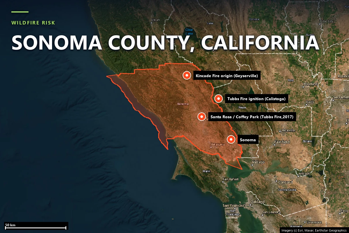
Satellite locator map headed “Wildfire risk — Sonoma County, California”, with the county boundary outlined and Sonoma, the Tubbs Fire ignition point near Calistoga and the Kincade Fire origin near Geyserville marked, plus a combined marker for Santa Rosa and Coffey Park
Sonoma County on satellite imagery — county boundary with Coffey Park, Santa Rosa, Sonoma, the 2017 Tubbs Fire ignition point, and the 2019 Kincade Fire origin marked. Imagery © Esri, Maxar, Earthstar Geographics.
Local context

A county whose fires keep changing shape

Sonoma County runs from the Pacific coast across the Russian River valley and the Mayacamas Mountains to the Napa County line, with most of its population concentrated in the valley floor around Santa Rosa, Sonoma, Petaluma, and Healdsburg. Four fires since 2017 define the county's modern wildfire record — and no two arrived the same way:

The fire season runs roughly June through November, but the county's most destructive events cluster in a narrow window: late-season north/northeast Diablo wind events in September and October, when fuel moisture is at its annual low and downslope winds can exceed 60 mph through the hills above the valley floor.

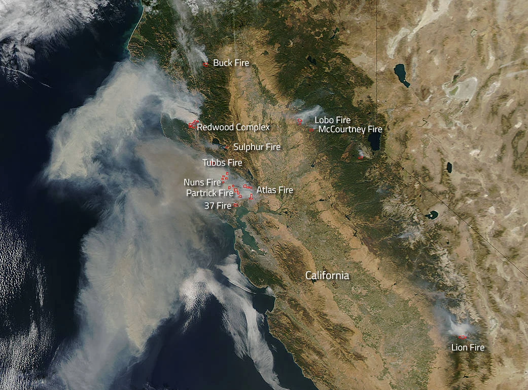
NASA Aqua satellite image from October 2017 showing smoke plumes from the Tubbs, Nuns, Atlas and other Northern California wildfires streaming out over the Pacific Ocean
The October 2017 Northern California firestorm from space — Tubbs, Nuns, Atlas, and neighboring fires all burning at once. Source: NASA / Jeff Schmaltz, LANCE/EOSDIS MODIS Rapid Response Team, GSFC, via Wikimedia Commons (public domain).

Sources: CAL FIRE Incident Archive · NIFC · NASA Earth Observatory.

Terrain & vegetation

Two different Sonoma Counties, one fire history

Most of Sonoma County's wildfire acreage burns in the hills: oak woodland and chaparral on the Mayacamas ridgelines above Calistoga and Geyserville, mixed conifer and grassland along the Russian River, vineyard-interspersed brush around Sonoma Valley. That is where the Nuns, Kincade, and Glass fires ran, and where CAL FIRE's Very High Fire Hazard Severity Zone designations concentrate.

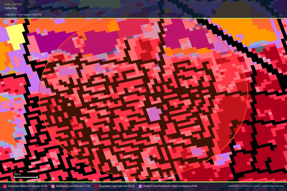
Coffey Park is a different terrain story entirely. It sits on the flat valley floor of the Santa Rosa Plain — no ridgeline, no canyon, no adjacent wildland fuel bed. Satelife's LANDFIRE read of the neighborhood puts its dominant land cover at roughly 69% developed/urban and 31% agricultural, with no forest or shrubland fuel class registering at all. The terrain layer for a Coffey Park property scores just 20 / 100 — coastal/valley-floor elevation banding, no slope to speak of.

That is exactly why the Tubbs Fire's arrival here was structurally different from a wildland-fire run. It didn't advance through continuous fuel; it threw embers more than 12 miles ahead of the flame front, igniting spot fires in landscaping, fences, and structure-to-structure combustion inside a fully built subdivision. Vegetation and terrain scores that would normally signal safety did not apply to the mechanism that actually destroyed the neighborhood.

LANDFIRE vegetation and fuel-type map of Coffey Park, Santa Rosa showing the neighborhood dominated by developed medium- and low-intensity land cover classes rather than wildland vegetation
LANDFIRE vegetation/fuel type over Coffey Park — the same layer a Satelife report scores. Developed land cover dominates; there is no wildland fuel bed for a fire to travel through. Source: LANDFIRE (USGS/USFS).
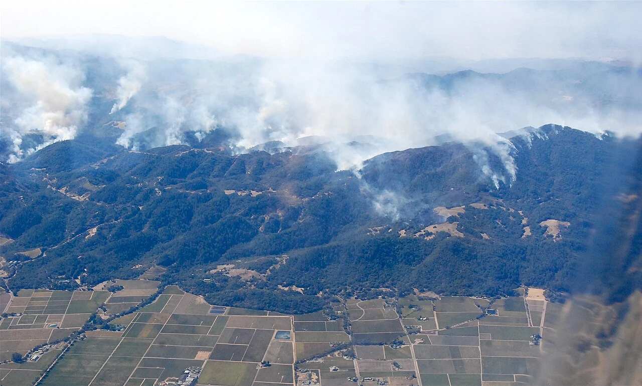
Aerial view of wildfire smoke rising from forested hills above Sonoma County vineyards during the October 2017 firestorm
Where most of the county's fire acreage actually burns: forested hills above the vineyard floor, October 2017. Source: California National Guard, via Wikimedia Commons (CC BY 2.0).
Evacuation

A dense grid with real redundancy — and one layer that didn't report back

Satelife's community-scale analysis of Coffey Park builds the evacuation picture from the actual road graph and structure footprints — 256 structures across roughly 254 hectares (the analyzed area — a 900 m radius circle centered on the neighborhood, since OpenStreetMap has no drawn polygon boundary for Coffey Park itself, only a place marker). The numbers:

256structures in the analyzed community area
25independent exit routes to the wider road network
~10structures per exit route
254 haanalyzed community area (~1 sq mile)

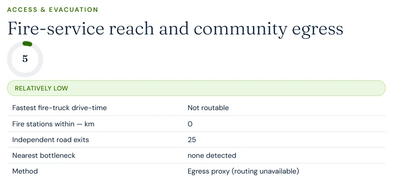
Twenty-five independent exits across 256 structures is a materially better ratio than the ridge-and-canyon communities this series has covered so far — the flat suburban grid simply offers more ways out per household. But the fire-truck drive-time layer came back "not routable" across three separate runs on this community — a routing-service gap, not a real absence of fire coverage: OpenStreetMap shows Santa Rosa Fire Department Station 3 mapped roughly 1.2 km from the neighborhood center. We are reporting the exit count and structure density as solid — they were consistent across every run — and flagging the drive-time figure as unavailable rather than inventing one.

Excerpt from a Satelife neighborhood wildfire report for Coffey Park: fire-service reach and community egress table showing fastest fire-truck drive-time as not routable, 0 fire stations found within search radius, 25 independent road exits, and method egress proxy routing unavailable
Report excerpt — Access & Evacuation, Satelife Neighborhood Wildfire Risk Report for Coffey Park, Santa Rosa, CA (July 2026). The suppression-routing sub-layer returned "Egress proxy (routing unavailable)" this cycle; the 25-exit count is from the independent road-redundancy analysis, which succeeded. Decision support, not an evacuation plan.
The hazard-zone illusion

A parcel the map calls NonWildland

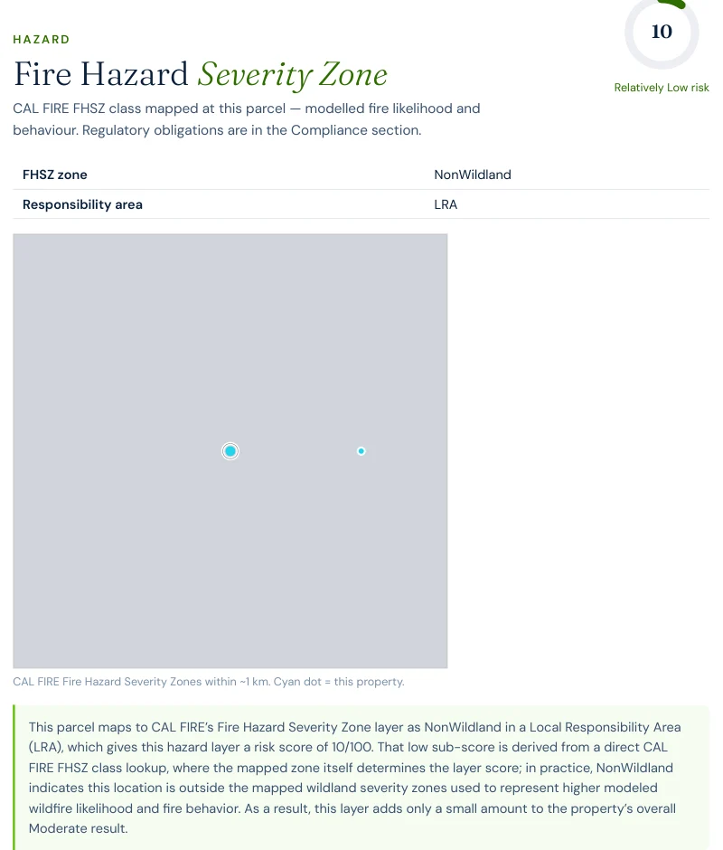
Here is Sonoma County's counterintuitive fact: run a Satelife report for a Coffey Park address today and CAL FIRE's Fire Hazard Severity Zone layer reads NonWildland — a Local Responsibility Area classification outside the mapped wildland severity zones altogether, scoring just 10 / 100 on the hazard layer. That is not a data error. It is the same classification this exact parcel carried in October 2017, the month the Tubbs Fire destroyed it.

FHSZ zone maps are built to represent wildland fuel adjacency and fire behavior in vegetated terrain. They are not built to represent:

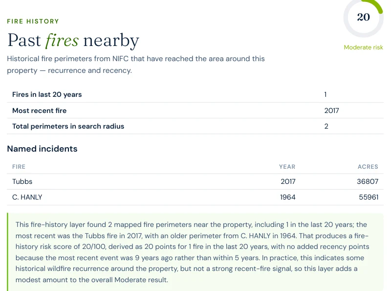
The fire-history layer disagrees with the hazard layer, and it is the one with a name to point to: it lists the Tubbs Fire, 2017, as the most recent perimeter reaching this exact parcel, alongside a much older 1964 C. Hanly Fire perimeter. A hazard score built from zone classification alone would have called this parcel safe on October 7, 2017.

Excerpt from a Satelife wildfire risk report for Coffey Lane, Coffey Park: Fire Hazard Severity Zone layer showing FHSZ zone NonWildland, Local Responsibility Area, hazard score 10 out of 100
Report excerpt — Fire Hazard Severity Zone layer, Satelife Wildfire Risk Report, Coffey Lane, Coffey Park, Santa Rosa, CA (July 2026). NonWildland / LRA classification, the same designation this parcel carried through the 2017 Tubbs Fire.
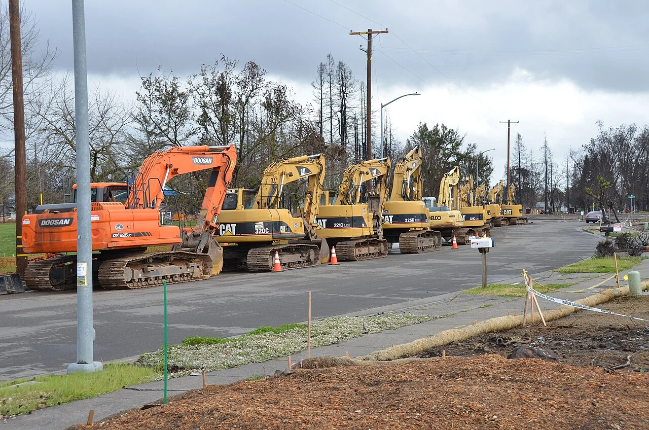
Row of excavators staged for debris removal along a burned residential street in Coffey Park, Santa Rosa, with scorched trees and cleared lots, one of the neighborhoods hardest hit by the 2017 Tubbs Fire
Debris-removal crews stage along a cleared Coffey Park street, one of the neighborhoods hardest hit by the October 2017 fires. Source: U.S. Army Corps of Engineers Sacramento District, via Wikimedia Commons (public domain).
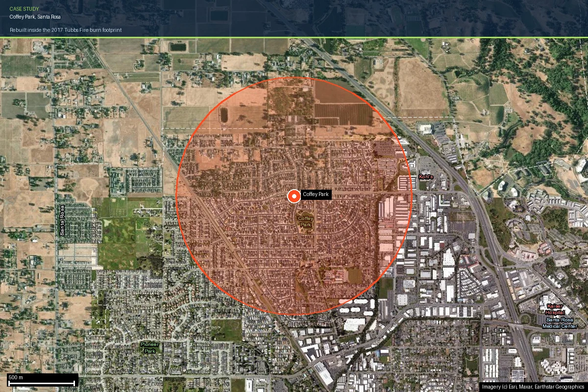
Coffey Park neighborhood boundary outlined on current satellite imagery, showing the fully rebuilt residential subdivision grid in Santa Rosa bounded by open agricultural fields to the north and a commercial corridor to the east
Coffey Park today — fully rebuilt, on current satellite imagery. The circle marks the area analyzed in Satelife's neighborhood report. Imagery © Esri, Maxar, Earthstar Geographics.
Case study

One address on Coffey Lane, scored today

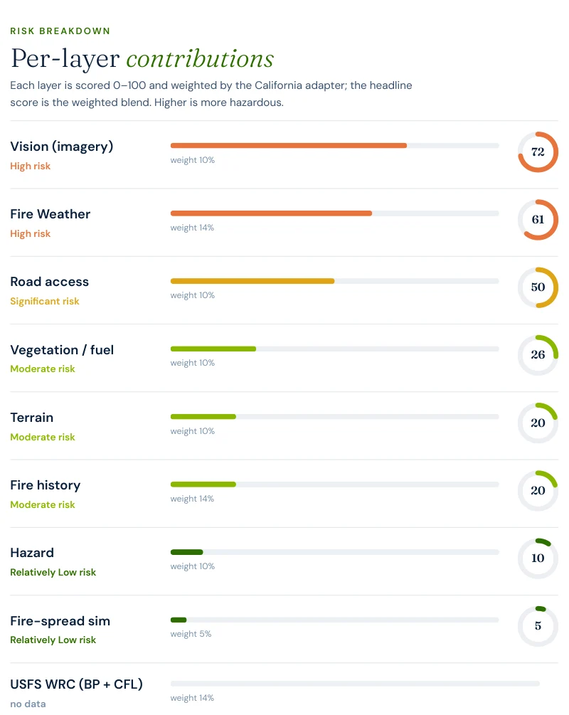
To make the county's risk concrete, we ran a full Satelife wildfire-risk report for a property on Coffey Lane, Coffey Park, Santa Rosa — inside the rebuilt subdivision, inside the Tubbs Fire's actual burn footprint. The composite score: 36 / 100 — Moderate tier (confidence 0.88), built from ten independently-scored data layers rather than one hazard polygon.

Excerpt from a Satelife wildfire risk report for Coffey Lane, Coffey Park: per-layer contributions showing Vision 72, Fire Weather 61, Road access 50, Vegetation 26, Terrain 20, Fire history 20, Hazard 10, Fire-spread simulation 5, USFS WRC no data
Report excerpt — Per-layer contributions, Satelife Wildfire Risk Report, Coffey Lane, Coffey Park, Santa Rosa, CA 95403 (July 2026). Composite 36/100, Moderate tier.

What actually drives the score here — notice it is not the hazard-zone layer:

Excerpt from a Satelife wildfire risk report: fire history layer listing the Tubbs Fire 2017 at 36,807 acres and C. Hanly 1964 at 55,961 acres, with 1 fire in the last 20 years and most recent 2017
Report excerpt — Fire history: the layer names the Tubbs Fire (2017, 36,807 acres) as the most recent perimeter reaching this parcel.
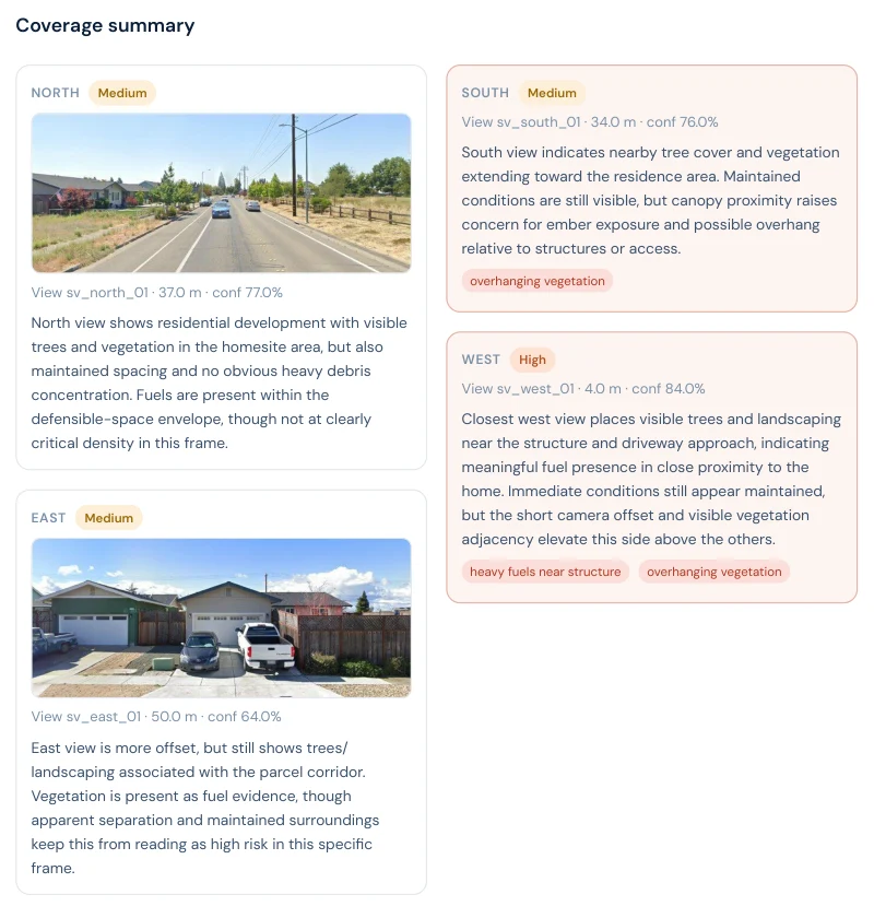
Excerpt from a Satelife wildfire risk report: street-view vision sweep with north, east, south and west findings — overhanging vegetation and heavy fuels near structure flagged on the west side
Report excerpt — Vision sweep by direction: the west view rates High, flagging "heavy fuels near structure" and "overhanging vegetation" closest to the home.
A zone map says this parcel is NonWildland — outside the areas its own model treats as wildfire terrain. A photograph from 2017 says otherwise. The report's job is to hold both facts at once and still tell you what to fix.

The report pairs the score with a prioritized mitigation plan for this exact parcel: audit defensible space annually before fire season even though it isn't legally mandated here, and verify the access route meets the 12 ft clear-width, 13'6" vertical clearance standard engines need. Under SB 1060-era rules, documenting that work still matters for a carrier conversation — even on a property the statute doesn't force to do it.

Insurance & real estate

Sonoma County's insurance market, post-2017

Sonoma County has felt the state's broader insurance retreat since 2017: carrier non-renewals across the county's hillside and WUI communities, with displaced homeowners migrating to the California FAIR Plan, the state's insurer of last resort, which surpassed 400,000 policies statewide in 2024 — roughly double its 2020 count. FAIR Plan coverage is thinner and more expensive than the admitted-market policies it replaces.

SB 1060 (in force 2025) requires carriers that use wildfire risk models to credit property- and community-level mitigation — but the statutory triggers run through hazard-zone classification. For hillside Sonoma County properties in mapped Very High zones, that creates a clear discount pathway. For a NonWildland-classified Coffey Park home with real 2017 fire history, the pathway is less direct — which is exactly the gap an address-level report, rather than a zone lookup, is built to surface.

For buyers and sellers, California Civil Code §1103 requires Natural Hazard Disclosure at the point of sale — tied to the same FHSZ classification. A Coffey Park listing may carry no disclosure trigger at all under that framework, even in a subdivision where nearly every home was rebuilt after a total loss. See California wildfire insurance and California real estate wildfire risk.

Sources: California Department of Insurance · California FAIR Plan · SB 1060 text · Civil Code §1103.

Risk reduction

What Sonoma County homeowners can actually do

CAL FIRE's defensible-space framework — Zone 0 (0–5 ft, ember-resistant), Zone 1 (5–30 ft, lean-clean-green), Zone 2 (30–100 ft, reduced fuel) — is legally required for properties in mapped SRA and LRA hazard zones. For hillside communities around Sonoma Valley, the Mayacamas, and the Russian River, that means annual compliance is not optional; the Sonoma County Fire Safe Council coordinates fuel-reduction work and evacuation-route planning across those areas. For NonWildland-classified suburbs like Coffey Park, the same defensible-space and hardening practices remain the best evidence of mitigation even though no statute compels them — ember-resistant vents, Class A roofing, and clearing combustibles against the structure address the exact mechanism that destroyed the neighborhood in 2017.

Annual review matters everywhere in the county, but for different reasons: hillside vegetation regrows fast after fire and needs re-clearing; Coffey Park's risk instead shifts with fire-weather trends and how consistently ember-resistant construction gets maintained street by street.

El Dorado County's case study tells a forested-canyon story: Grizzly Flats carries a CAL FIRE Very High hazard score of 90/100 and a 32-minute modelled fire-truck drive-time from the nearest full-time station. Coffey Park is close to its structural opposite — a NonWildland hazard score of just 10/100 and, on the redundancy side, a materially tighter ratio of roughly 10 structures per exit route versus Grizzly Flats' ~29 — yet Coffey Park's real fire history is not a hypothetical: it names the same kind of destructive, recent, named megafire that Grizzly Flats in El Dorado County does. The lesson across both pages is the same read on two different instruments: a low score on any single layer — hazard zone here, egress there — is not a low-risk verdict on its own.
Coverage

ZIP codes we cover in Sonoma County

Satelife runs address-level wildfire reports across every ZIP code in Sonoma County. The ZIPs below are the high Fire Hazard Severity Zone, Wildland-Urban Interface communities we are asked about most. One caveat that is the whole point of what we do: the risk score is computed for your parcel, not the ZIP, so two homes on the same street can land in different tiers. Find your area, then run your address.

ZIP code Community Why it is on the map
95403 Santa Rosa Tubbs Fire (2017) / Coffey Park; Coffey Lane case study
95409 Santa Rosa Fountaingrove; Tubbs and 2020 Glass Fire exposure
95442 Glen Ellen Nuns Fire (2017), Sonoma Valley WUI
95452 Kenwood Nuns and Glass Fire corridor, Mayacamas WUI
95448 Healdsburg Kincade Fire (2019) evacuation zone
95441 Geyserville Kincade Fire ignition area, Geysers WUI
95476 Sonoma Nuns Fire southern front, valley-edge WUI
95492 Windsor Kincade Fire mass-evacuation footprint

ZIP areas per USPS; Wildland-Urban Interface and Fire Hazard Severity Zone framing per CAL FIRE.

Where to go next

Sonoma County wildfire risk in context

FAQ

Frequently asked questions about Sonoma County wildfire risk

Is Sonoma County a high wildfire risk area?

Yes, but unevenly. The forested and vineyard-hill terrain in the Mayacamas range, the Sonoma Valley, and the Russian River corridor carries CAL FIRE High and Very High Fire Hazard Severity Zone designations and has produced the Nuns (2017), Kincade (2019), and Glass (2020) fires. The valley-floor suburbs of Santa Rosa, including Coffey Park, are officially classified NonWildland — yet Coffey Park was almost entirely destroyed by the 2017 Tubbs Fire. Zone classification and real fire history do not always agree.

What was the largest wildfire in Sonoma County?

By acreage, the 2019 Kincade Fire — 77,758 acres, the largest single fire in Sonoma County history, ignited near Geyserville and contained November 6, 2019 with 374 structures destroyed. By destruction, the 2017 Tubbs Fire remains the benchmark: 5,636 structures destroyed across Sonoma County, more than any single California wildfire before the 2025 Palisades and Eaton fires.

Why did the Tubbs Fire destroy homes far from any forest?

The Tubbs Fire ignited near Calistoga on the night of October 8, 2017, and wind-driven embers carried it more than 12 miles, jumping six lanes of Highway 101 to ignite Coffey Park directly — a flat, fully built suburban subdivision with no adjacent wildland vegetation. This is an ember-driven urban conflagration, not a classic wildland fire spreading through fuel: a current Satelife hazard-layer read of a Coffey Park address still classifies the parcel NonWildland, the same classification it carried in 2017.

Is it safe to rebuild in Coffey Park after the Tubbs Fire?

Rebuilding is essentially complete. Because the parcel sits outside CAL FIRE's mapped Fire Hazard Severity Zones, state defensible-space law (PRC §4291) and the Chapter 7A WUI building code are not legally required here — a current Satelife report for a Coffey Park address confirms both show as "not required" under the compliance layer. Many rebuilt homes voluntarily adopted ember-resistant vents, Class A roofing, and non-combustible siding anyway, since the mechanism that destroyed the neighborhood in 2017 was embers, not radiant heat from adjacent brush.

Can wildfire mitigation lower my insurance premium in Sonoma County?

For hillside properties in mapped hazard zones, yes — SB 1060 (in force 2025) requires California carriers that use wildfire risk models to credit documented mitigation. For a NonWildland-classified property like a Coffey Park home, the regulatory mitigation-discount pathway does not apply the same way, since the statutory triggers are zone-based — even though the property has real, documented fire history. That gap is precisely why an address-level risk read, not just a zone lookup, matters for insurance conversations here.

Scores and evacuation figures on this page are drawn from Satelife wildfire-risk reports for Coffey Park, Santa Rosa, CA generated in July 2026 (property report, Coffey Lane; neighborhood analysis, a 900 m radius centered on the Coffey Park neighborhood — OpenStreetMap has no drawn boundary polygon for Coffey Park itself). The neighborhood report's fire-truck drive-time sub-layer returned "routing unavailable" across three runs and is not presented as a finding. Satelife reports are informational decision support — not a substitute for official evacuation orders, CAL FIRE hazard determinations, or an insurer's underwriting judgement.

What does your parcel look like, layer by layer?

If you own, are buying, or are rebuilding in Sonoma County — Coffey Park, Fountaingrove, Oakmont, Geyserville, or anywhere across the county — get the address-level answer: PDF, ten-layer score, and a prioritized mitigation plan.

Start with your address →