HomeWildfire RiskCaliforniaNapa County
Napa County, California · 2026

Wildfire risk in Napa County: when the fire runs through the vineyards

The 2020 Glass Fire burned 67,484 acres and 1,555 structures — including more than 30 wineries, restaurants and lodges — from a pre-dawn ignition near Glass Mountain Road in Deer Park through St. Helena and into Calistoga. A current Satelife property report for a Silverado Trail address in Calistoga reads 59.9/100, High tier, and names the Glass Fire directly. This page maps Napa County's wildfire risk with satellite data and two real Satelife reports run from inside Calistoga in July 2026.

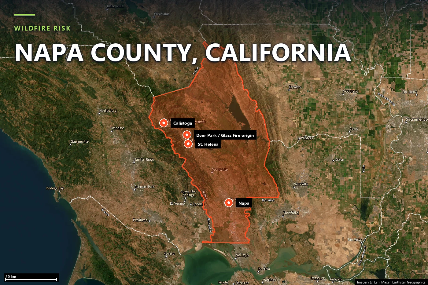
Satellite locator map headed “Wildfire risk — Napa County, California”, with the county boundary outlined and Calistoga, St. Helena and Napa marked, plus a combined marker for Deer Park and the 2020 Glass Fire origin near Glass Mountain Road
Napa County on satellite imagery — county boundary with Calistoga, Deer Park, St. Helena, Napa, and the 2020 Glass Fire origin point near Glass Mountain Road marked. Imagery © Esri, Maxar, Earthstar Geographics.
Local context

A valley economy built on the thing that keeps burning

Napa County runs from the marshes at the top of San Pablo Bay north through the narrow Napa Valley floor — Napa, Yountville, St. Helena, Calistoga — to the forested ridgelines of the Mayacamas and Vaca ranges that wall the valley in on both sides. Nearly all of the county's wine industry sits on that valley floor, hemmed in by exactly the mixed-conifer and chaparral slopes where the county's largest fires start and run. The recent record:

Unlike a forest-only fire, the Glass Fire's destruction list reads like a wine-country gazetteer: more than 30 wineries, restaurants and lodges were destroyed or damaged, including the 41-year-old Chateau Boswell Winery and the three-Michelin-starred restaurant at Meadowood Napa Valley, while Castello di Amorosa alone lost roughly $5 million in wine inventory. The fire season here runs June through October, with the most destructive events historically clustering in late September and October, when offshore Diablo wind events coincide with cured, tinder-dry grass and brush.

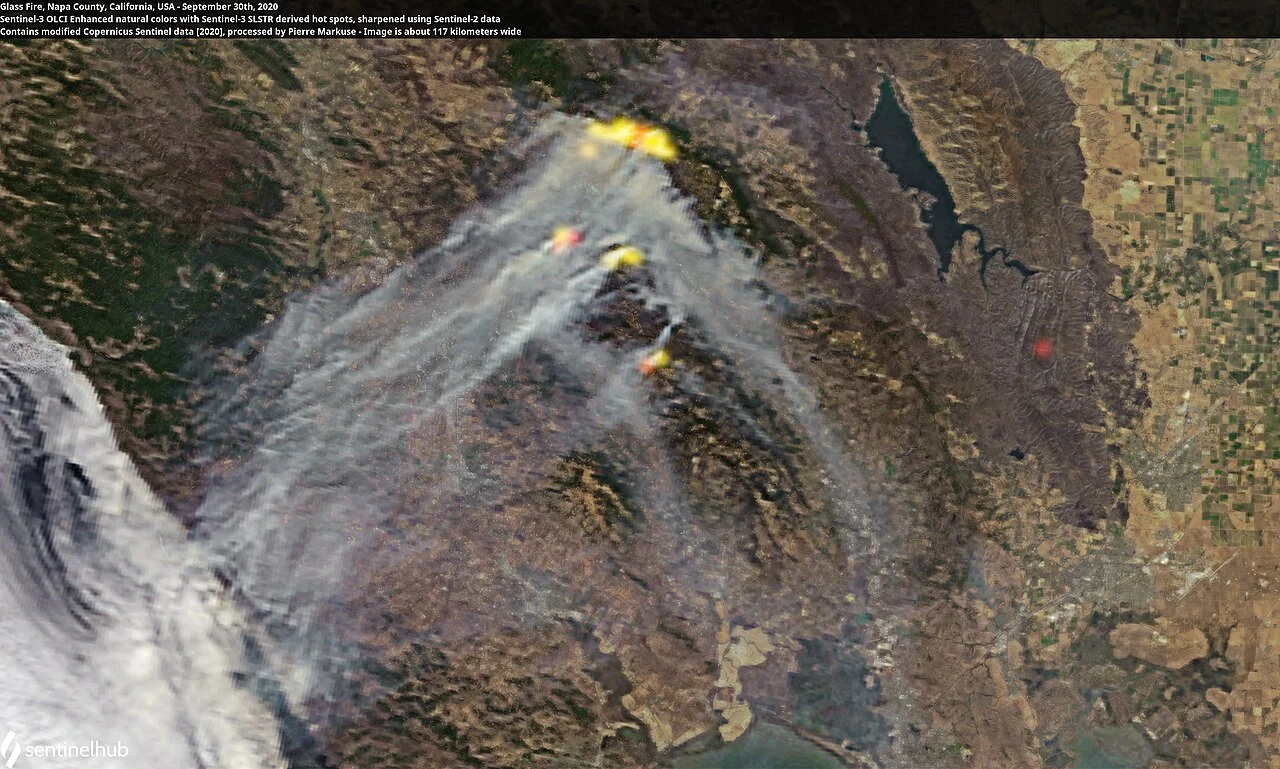
Sentinel-3 satellite image from September 30, 2020 showing active fire hotspots and smoke plumes of the Glass Fire spreading southeast across Napa County toward Lake Hennessey
The Glass Fire's active hotspots (yellow/red) and smoke, seen by Sentinel-3, September 30, 2020 — the burn scar runs southeast across the ridge above Calistoga and St. Helena toward Lake Hennessey. Source: Pierre Markuse, contains modified Copernicus Sentinel data, via Wikimedia Commons (CC BY 2.0).

Sources: CAL FIRE Incident Archive · NIFC · Wikipedia (Glass Fire, Atlas Fire).

Terrain & vegetation

Vineyards, forest, and town, stitched together

Calistoga sits at the head of the Napa Valley, in a bowl formed where the Mayacamas and Vaca ranges nearly meet — the same terrain that channeled the Glass Fire's run down from Deer Park. A Satelife property report for a Silverado Trail address here scores the terrain layer at 40 / 100, an elevation-banded foothills reading (113 m) that reflects the valley-floor-to-ridge transition rather than a single steep slope.

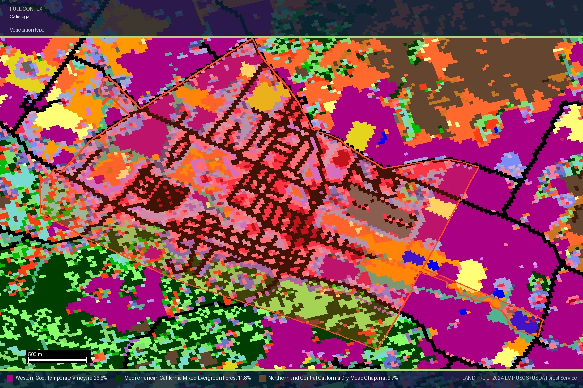
The vegetation layer tells the more distinctive story. Satelife's LANDFIRE-based fuel mix for the Silverado Trail parcel reads 45 / 100, built from a near-even split of forest (38%), agricultural land (31%), and urban cover (31%) inside the 100-metre buffer — literally vineyard, woodland, and town in the same neighbourhood. A LANDFIRE vegetation map centered on Calistoga confirms it at the community scale: Western Cool Temperate Vineyard is the single largest mapped class at 27%, with Mediterranean mixed-evergreen forest (12%) and dry-mesic chaparral (10%) filling in the hillsides around it. That mosaic is exactly what makes wine-country WUI different from the Sierra foothills or Southern California chaparral belts covered elsewhere on this site — vineyards act as partial fuel breaks in places, and dense woodland and structures in others, often on the same block.

LANDFIRE vegetation map of Calistoga, California, showing the Calistoga city boundary over a mosaic of Western Cool Temperate Vineyard (magenta), Mediterranean California Mixed Evergreen Forest (dark green), and Northern and Central California Dry-Mesic Chaparral (brown)
LANDFIRE vegetation classes around Calistoga — vineyard (magenta) is the single largest class at 27%, ringed by mixed-evergreen forest and chaparral on the surrounding slopes. Source: LANDFIRE LF2024 EVT, USGS / USDA Forest Service.
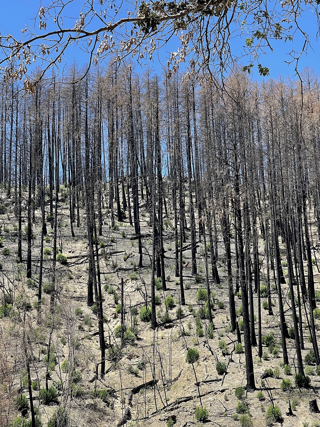
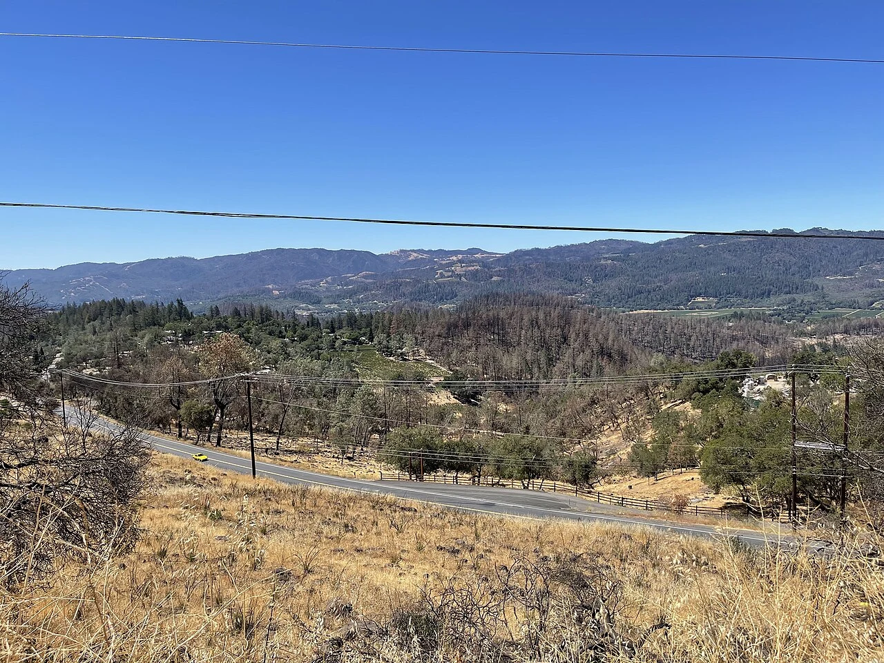
Standing dead conifers on a hillside near Deer Park, California, roughly a year after the 2020 Glass Fire, with green regrowth sprouting at the base of the burned trunks
Standing dead conifers above Deer Park, August 2021 — regrowth already visible at the base of the burned trunks, roughly a year after the Glass Fire. Source: Missvain (Sarah Stierch), via Wikimedia Commons (CC BY 4.0).
Evacuation

Hazard maps say where fire is likely. They say nothing about whether you can leave

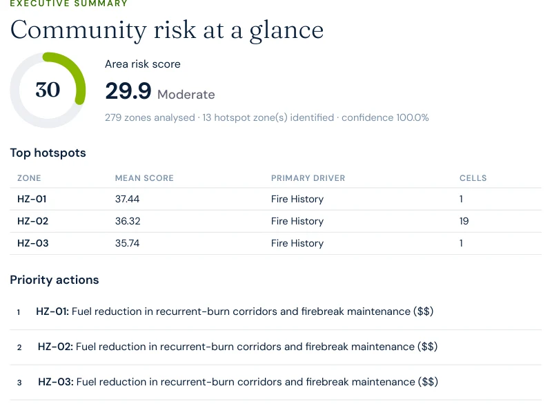
Satelife's community-scale analysis of Calistoga builds the evacuation picture from the actual road graph and structure footprints — 343 structures across 673 hectares, gridded into 279 zones and scored at 29.9 / 100 — Moderate area-wide (100% confidence). Thirteen hotspot zones were identified, every one of them driven primarily by fire history rather than access difficulty.

Excerpt from a Satelife neighborhood wildfire report for Calistoga: executive summary showing area risk score 29.9 Moderate, 279 zones analysed, 13 hotspot zones identified, and fire history as the primary driver in the top hotspots
Report excerpt — Executive summary, Satelife Neighborhood Wildfire Risk Report for Calistoga, CA (July 2026).
343structures in the analyzed community area
12independent exit routes to the wider road network
~29structures per exit route
1.4 minmodelled fire-truck drive-time from the nearest mapped station (0.76 km)

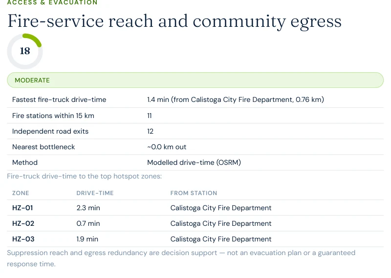
Fire-service reach here is the fastest of any Satelife county page published so far — Calistoga City Fire Department sits 0.76 km from the analyzed area, a 1.4-minute modelled drive-time, and 11 stations are mapped within 15 km. Drive-times to the three hotspot zones run 0.7 to 2.3 minutes, all from that same in-town station. What the analysis flags instead is a wider single-point-of-failure segment than any other county page published to date: roughly 35 metres that multiple evacuation paths depend on, versus 11–21 metres in the Sierra foothill, backcountry, and Santa Monica Mountains communities covered elsewhere on this site. Twelve exits across 343 structures is workable in isolation, but a fire station in town does not by itself resolve how many structures share that one wider chokepoint if it fails.

Excerpt from a Satelife neighborhood wildfire report for Calistoga, California: fire-service reach and community egress table showing 1.4-minute fastest fire-truck drive-time from Calistoga City Fire Department, 11 stations within 15 km, 12 independent road exits, and a roughly 35-metre nearest bottleneck
Report excerpt — Access & Evacuation, Satelife Neighborhood Wildfire Risk Report for Calistoga, CA (July 2026). Modelled OSRM drive-times from OSM-mapped stations. Decision support, not an evacuation plan.
The post-fire cycle

The vines came back fast. The hazard rating didn't move

Calistoga's vineyards were replanted within a season or two of the Glass Fire — vines are a managed, irrigated crop, not wildland fuel left to its own devices, so the valley floor greened up quickly. It would be easy to read that recovery as the risk having passed. It hasn't:

Meanwhile the hillside forest and chaparral — not the vineyards — are what actually carry the next fire, and those fuels regrow on a much longer, much less managed cycle than a vine row. A green valley floor in 2026 says nothing about the ridge above it.

It also explains a real split between the county's two Satelife reports. Averaged across Calistoga's full 279-zone grid, the hazard layer reads a comparatively low 10/100 — CAL FIRE's Very High zones concentrate on the wildland fringe north and east of downtown, not the built core the town boundary mostly covers. The Silverado Trail case-study parcel, on that fringe rather than in the town center, reads 90/100 on the same layer. A community-wide average and a single parcel's score are answering two different questions — which is exactly why this page runs both a neighborhood report and a property report rather than either alone.

Hillside view above Deer Park, California, showing a mix of dead fire-scorched trees, green regrowth, and vineyard rows in the valley below, roughly a year after the 2020 Glass Fire
The Glass Fire burn zone above Deer Park, August 2021 — scorched hillside forest directly overlooking green, replanted vineyard rows on the valley floor. Source: Missvain (Sarah Stierch), via Wikimedia Commons (CC BY 4.0).
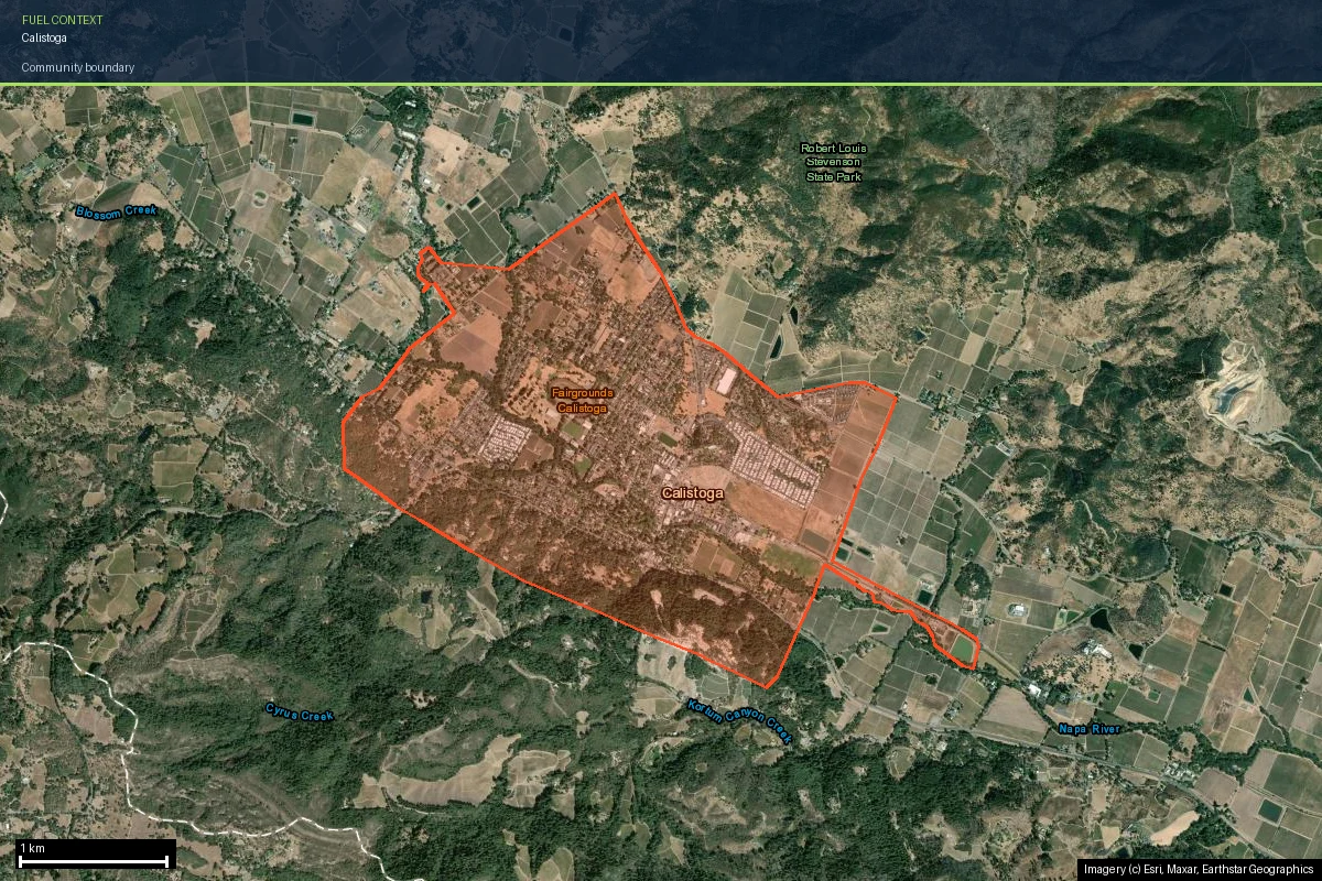
Calistoga community boundary outlined on current satellite imagery, showing the town surrounded by vineyard blocks and forested hillsides near Robert Louis Stevenson State Park
The Calistoga boundary on current satellite imagery — vineyard blocks ring the town, with forested slopes rising toward Robert Louis Stevenson State Park to the north. Imagery © Esri, Maxar, Earthstar Geographics.
Case study

One address on Silverado Trail, scored today

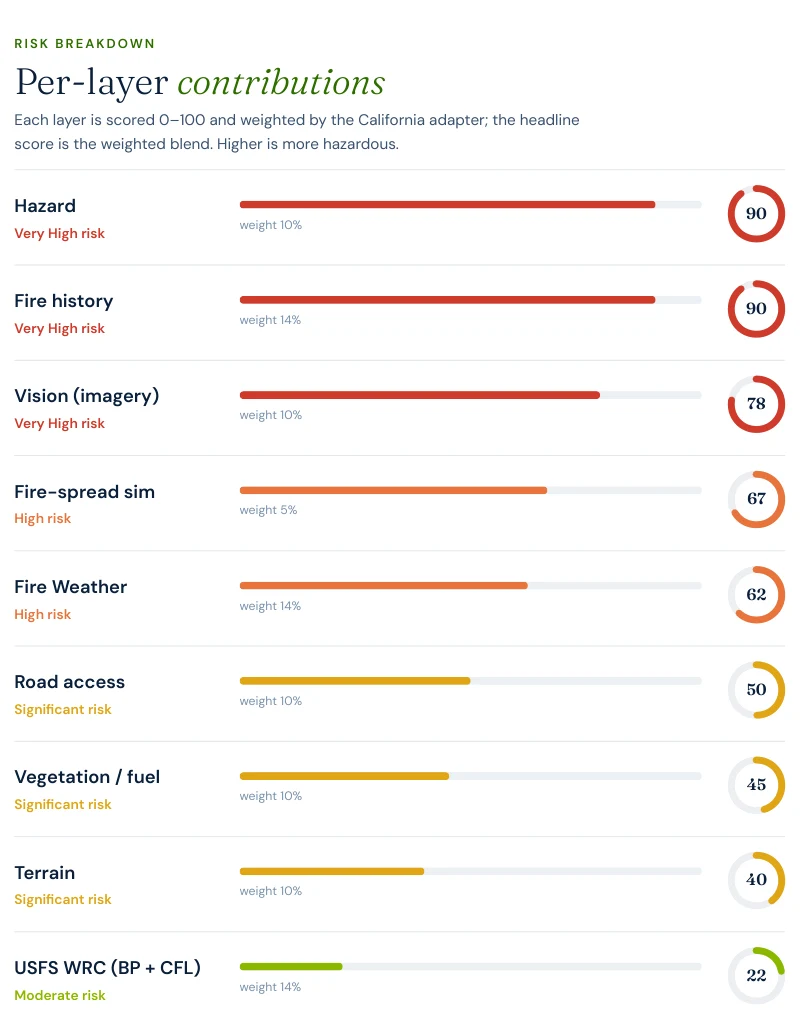
To make the county's risk concrete, we ran a full Satelife wildfire-risk report for a property on Silverado Trail, Calistoga — inside the area the Glass Fire reached in 2020. The composite score: 59.9 / 100 — High tier (78% confidence), built from ten independently-scored data layers rather than one hazard polygon.

Excerpt from a Satelife wildfire risk report for Silverado Trail, Calistoga: per-layer contributions showing Hazard 90, Fire history 90, Vision 78, Fire-spread sim 67, Fire weather 62, Road access 50, Vegetation 45, Terrain 40, USFS WRC 22
Report excerpt — Per-layer contributions, Satelife Wildfire Risk Report, Silverado Trail, Calistoga, CA 94515 (July 2026). Composite 59.9/100, High tier.

What drives the score:

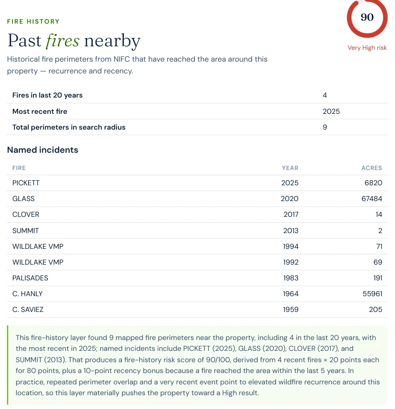
Excerpt from a Satelife wildfire risk report: fire history layer listing the Pickett Fire 2025, the Glass Fire 2020 at 67,484 acres, and the historic 1964 C. Hanly fire at 55,961 acres, among 4 fires in the last 20 years and 9 total mapped perimeters
Report excerpt — Fire history: the layer names the Glass Fire (2020, 67,484 acres) among the perimeters reaching this parcel, alongside the 2025 Pickett Fire and the historic 1964 C. Hanly fire.
Excerpt from a Satelife wildfire risk report: street-view vision sweep showing the north view rated High risk with heavy fuels near the structure and overhanging vegetation, and the east view rated Medium
Report excerpt — Vision sweep by direction: the north view rates High, with findings like "heavy fuels near structure" and "overhanging vegetation".
The FHSZ polygon says "Very High" for every parcel along this stretch of Silverado Trail equally. The report says this house has overhanging canopy on its north side — and which three actions, in order, change that.

The report pairs the score with a prioritized mitigation plan for this exact parcel: establish an ember-resistant Zone 0 in the first five feet, harden the roof and screen vents against ember intrusion, and maintain thirty feet of lean, clean and green space. Under SB 1060-era rules, completing and documenting that work is not just safety advice — it is insurance evidence.

Insurance & real estate

The insurance squeeze in Napa County

County homeowners feel all of the above through their insurance bill — when they can get one. Since the 2017 and 2020 fires, the pattern across Napa Valley's WUI communities has been carrier non-renewals followed by migration to the California FAIR Plan, the state's insurer of last resort, which surpassed 400,000 policies statewide in 2024 — roughly double its 2020 count. FAIR Plan coverage is more expensive and thinner than the policies it replaces, a particular strain in a county where much of the insured value sits in wine-production buildings and equipment as well as homes.

The regulatory response matters here: SB 1060 (in force 2025) requires carriers that use wildfire risk models to account for property- and community-level mitigation — defensible space, home hardening, community fuel breaks — rather than pricing on hazard zone alone. Together with the Safer from Wildfires framework, that creates a financial reason to prove, with evidence, what your specific parcel looks like. A zone map can't do that. An address-level report can.

For buyers and sellers, California Civil Code §1103 requires Natural Hazard Disclosure at the point of sale — and as insurance availability tightens, fire-zone status becomes a closing-risk variable rather than a paperwork item. A buyer who cannot bind insurance cannot close. See California wildfire insurance and California real estate wildfire risk.

Sources: California Department of Insurance · California FAIR Plan · SB 1060 text.

Risk reduction

What Napa County homeowners can actually do

CAL FIRE's defensible-space framework defines three zones: Zone 0 (0–5 ft, ember-resistant, no combustibles), Zone 1 (5–30 ft, lean-clean-green), and Zone 2 (30–100 ft, reduced fuel). Documented compliance is what underwriters and the SB 1060 discount process accept as evidence. Locally, the Napa County Firewise Foundation and community Firewise USA groups in Calistoga and Deer Park coordinate fuel-reduction work on the hillsides above the valley floor, while CAL FIRE Sonoma-Lake-Napa Unit (LNU) runs wildland suppression response across the county.

Annual review is the rule, not the exception: vegetation regrows, and in a county that has already produced two 50,000+ acre fires in seven years, a multi-year gap between inspections is not a safe assumption. A parcel that passed inspection in 2024 is not necessarily compliant in 2026.

Calistoga's evacuation profile looks different from every other county covered on this site. San Diego County's Ramona Fire Station #81 answers in 3.5 minutes, and El Dorado County's Grizzly Flats waits 32 minutes for a full-time station 22.8 km away — Calistoga beats both at 1.4 minutes from a station inside town. But the same report found the widest identified single-point-of-failure segment of any of the four communities: roughly 35 metres here, versus 20 in Grizzly Flats, 21 in San Diego Country Estates, and 11 in Malibu's Las Flores Canyon. Fast trucks and a wide chokepoint are not the same problem as slow trucks and a narrow one, but they can produce a similar result if that one segment fails.

Every county page on this site so far has paired a fire-legacy story with an access constraint — slow trucks in the Sierra foothills, chokepoint geometry in the backcountry and the canyons. Calistoga is the first with fast trucks and the widest bottleneck on record. The hazard number that matters is never the same one twice — which is the whole argument for scoring the actual parcel and the actual community instead of reading one statewide zone map.
Coverage

ZIP codes we cover in Napa County

Satelife runs address-level wildfire reports across every ZIP code in Napa County. The ZIPs below are the high Fire Hazard Severity Zone, Wildland-Urban Interface communities we are asked about most. One caveat that is the whole point of what we do: the risk score is computed for your parcel, not the ZIP, so two homes on the same street can land in different tiers. Find your area, then run your address.

ZIP code Community Why it is on the map
94515 Calistoga Glass Fire (2020); Silverado Trail case study on this page
94574 St. Helena Ridge WUI above the valley floor, on the Glass Fire burn path
94576 Deer Park Glass Fire ignition area near Glass Mountain Road
94508 Angwin Howell Mountain forest WUI, High/Very High FHSZ
94567 Pope Valley Remote eastern valley, limited egress, LNU Complex exposure
94558 Napa Eastern hills and Coombsville; the 2017 Atlas Fire burned here
94599 Yountville Mayacamas foothill edge west of the valley floor

ZIP areas per USPS; Wildland-Urban Interface and Fire Hazard Severity Zone framing per CAL FIRE.

Where to go next

Napa County wildfire risk in context

FAQ

Frequently asked questions about Napa County wildfire risk

Is Napa County a high wildfire risk area?

Yes. The forested ridges that ring the Napa Valley floor — above Calistoga, Deer Park, St. Helena, and Angwin — sit in CAL FIRE High or Very High Fire Hazard Severity Zones. The county has absorbed two 50,000+ acre wildfires in a seven-year span: the 2017 Atlas Fire (51,624 acres, 783 structures destroyed) and the 2020 Glass Fire (67,484 acres, 1,555 structures destroyed).

What was the largest wildfire in Napa County?

The 2020 Glass Fire — 67,484 acres across Napa and Sonoma counties. It ignited before dawn on September 27, 2020 near Glass Mountain Road in Deer Park, burned through St. Helena and into Calistoga, and was not fully contained until October 20. It destroyed 1,555 structures, including 308 homes and 343 commercial buildings in Napa County alone, with no fatalities or injuries reported.

Did the Glass Fire destroy any Napa Valley wineries?

Yes. The Glass Fire destroyed or damaged more than 30 wineries, restaurants and lodges, including the 41-year-old Chateau Boswell Winery and the three-Michelin-starred restaurant at Meadowood Napa Valley, and caused roughly $5 million in wine-inventory losses at Castello di Amorosa. A current Satelife hazard layer for a Calistoga-area address still reads 90/100, Very High.

How do I check the fire hazard zone for my Napa County address?

Use the CAL FIRE FHSZ viewer for the official Moderate / High / Very High zone classification. For property-level detail — terrain, fuels, fire history, evacuation constraints, and an AI read of your actual parcel imagery — run a Satelife address-level report.

Can wildfire mitigation lower my insurance premium in Napa County?

Yes. Under SB 1060 (in force 2025), California carriers that use wildfire risk models must account for property- and community-level mitigation. Documented defensible space and home hardening — the kind of evidence a Satelife report captures — feeds directly into that discount pathway, alongside the Safer from Wildfires framework.

Scores and evacuation figures on this page are drawn from Satelife wildfire-risk reports for Calistoga, CA generated in July 2026 (property report, Silverado Trail; neighborhood analysis, Calistoga city boundary). Satelife reports are informational decision support — not a substitute for official evacuation orders, CAL FIRE hazard determinations, or an insurer's underwriting judgement.

What does your parcel look like, layer by layer?

If you own, are buying, or are rebuilding in Napa County — Calistoga, Deer Park, St. Helena, or anywhere in the valley's wine-country WUI — get the address-level answer: PDF, ten-layer score, and a prioritized mitigation plan.

Start with your address →