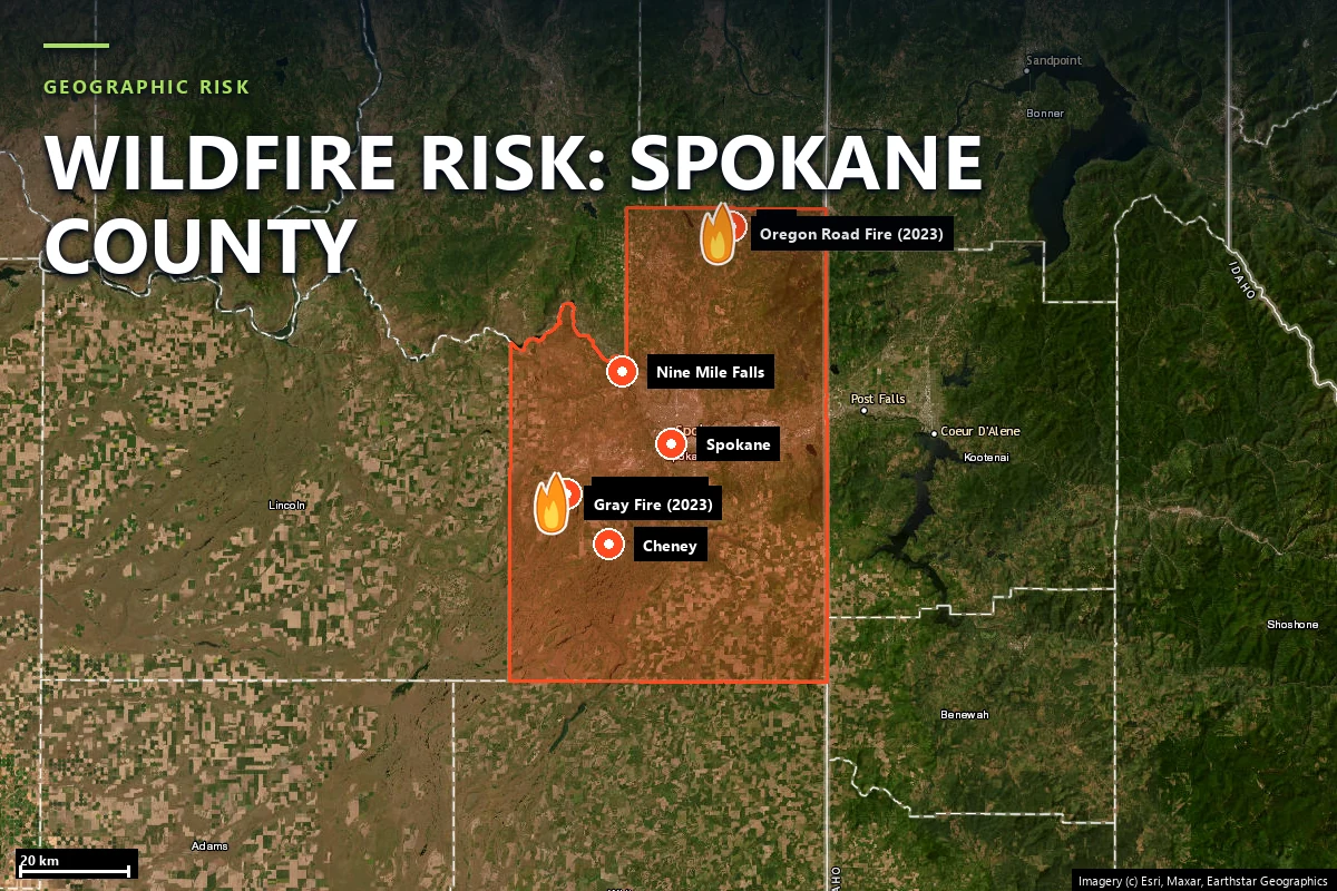
Wildfire risk in Spokane County: the fires keep reaching town
Three times in living memory, wildfire has burned into Spokane County neighborhoods:
92 wind-driven fires in one October day in 1991, the Gray and Oregon Road fires that
destroyed over 600 structures on a single August afternoon in 2023, and the Old Trails,
Autumn Lane and Fairview fires that forced 67,000 people to evacuate this month. Our
Satelife report for a Medical Lake address returns 49 / 100 — Moderate tier
with fire history at 90 / 100 — and finds a single approach
route whose first bottleneck sits 55 feet from the parcel.
Spokane County's fire problem is not remote forest burning somewhere upwind. It is fire
arriving in town, repeatedly, on the same weather pattern:
16 October 1991 — Firestorm '91. After 42 days without rain, winds gusting
to 62 mph downed power lines across the region and ignited 92 fires in a single
day, burning roughly 35,000 acres, destroying 114 homes and killing two people.
18 August 2023 — the Gray and Oregon Road fires, the same afternoon. The
Gray Fire burned 10,085 acres through Medical Lake and Four Lakes, destroyed
240 structures and killed one person. The Oregon Road Fire burned
10,817 acres near Elk, destroyed 384 structures — 126 of
them primary residences — and also killed one person.
1 August 2026 — the Spokane-area fires, still in mop-up as this page is written.
The Old Trails Fire (3,226 acres, an arson start) burned into north Spokane neighborhoods;
with the Autumn Lane (5,784 acres) and Fairview (992 acres) fires it damaged or destroyed
over 900 structures by early-August counts and put some
67,000 people under evacuation.
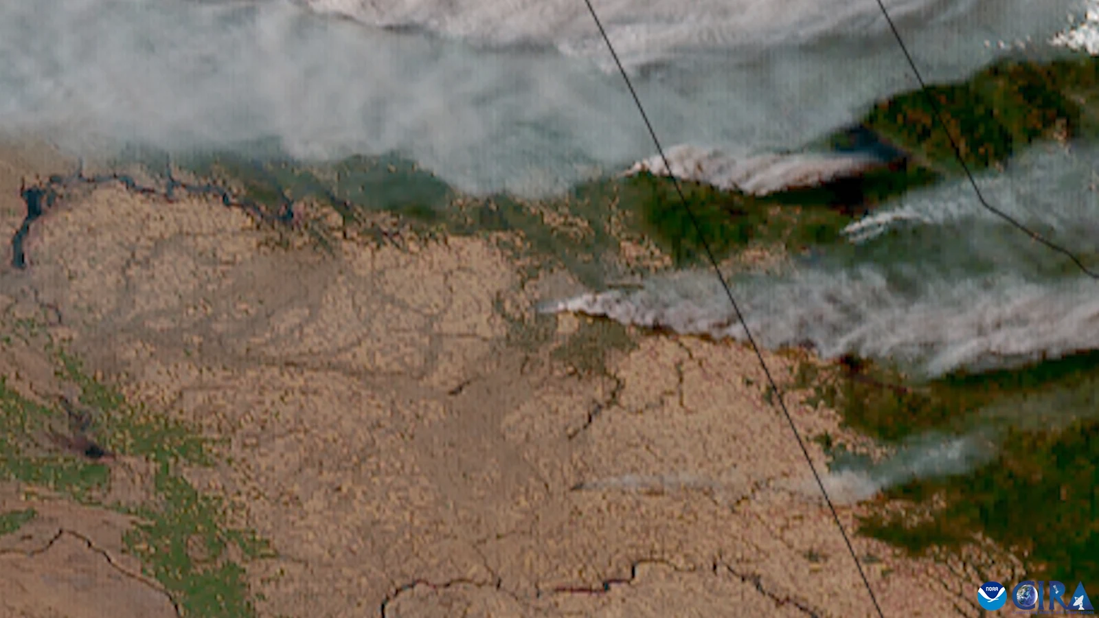
Two towns, one day: GOES satellite view, 19 August 2023 — the Gray Fire (lower plume, at
Medical Lake) and the Oregon Road Fire (upper plume, near Elk) burning simultaneously.
Source: CSU/CIRA & NOAA, via
Wikimedia Commons
(public domain).
Sources: Washington DNR annual wildfire season reporting · NIFC / WFIGS fire perimeters ·
HistoryLink (Firestorm '91) · Spokane County emergency management and contemporaneous
Spokesman-Review, KHQ and KXLY reporting for the 2023 and 2026 fires.
Terrain & fuel
Ponderosa parkland on the channeled scablands
The county sits where the Columbia Basin's shrub-steppe climbs into the Selkirk foothills.
Its signature fuel is ponderosa pine parkland over cured grass — open,
park-like stands threaded through basalt scabland left by the Missoula floods, with lakes in
the channels and houses among the trees. West of Spokane, the West Plains around Medical
Lake, Airway Heights and Cheney are flat, windy and fast-burning; north of the city the
timber thickens toward Elk and Deer Park. Both 2023 fires ran through exactly these fuels,
in opposite corners of the county, on the same wind.
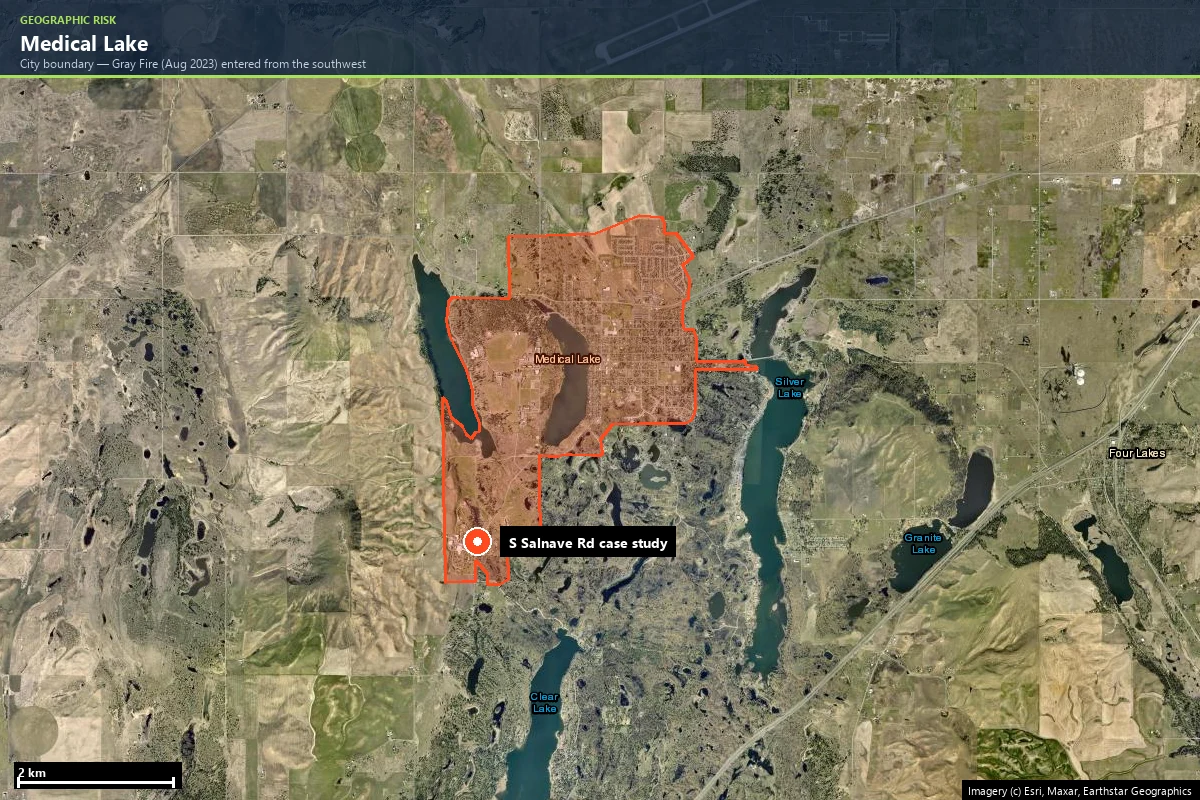
Our community-scale analysis uses the Medical Lake city boundary —
954 hectares, gridded into 297 analysis zones. The area
vegetation layer reads 52 / 100, and the report's surroundings table for our
case-study parcel puts the nearest forest wildland front about 656 feet to the
west — the direction the Gray Fire came from. Inside the parcel's own 328-foot ring,
LANDFIRE classifies the fuel as 100% urban: lawns, streets and houses. That
pairing — developed ground with a wildland front two football fields away — is the West
Plains WUI in one row of a table.
Climate does the rest. The fire-weather layer — a thirty-year ERA5 climatology of the
Canadian Fire Weather Index — scores 62 / 100 at the parcel, and terrain
adds 65 / 100. Summers here end dry: the 1991 Firestorm followed 42 rainless
days, and every fire named on this page started between late July and mid-October.
Evacuation
A town of lakes with 25 ways out
Medical Lake evacuated through smoke twice in one afternoon in 2023 — the town itself for the
Gray Fire, and the state institutions on its lakeshore under their own protocols. Satelife's
neighborhood analysis rebuilds that geometry from the current road graph:
297analysis zones across the 954-hectare city boundary
25independent road exits — no single point of failure detected
10.5 minfastest modelled fire-engine arrival, from a station 6.6 km out
12.5–13.6 minmodelled engine times to the three highest-risk zones
Twenty-five independent exits for 297 zones — 11.9 zones per exit — is a
genuinely redundant network for a town this size; the same analysis found no single point of
failure. Eleven stations sit within the search radius, including Fairchild Air Force
Base Fire Department and Spokane County Fire District 3's Station 33. The caveat
belongs in the same breath: drive-times are modelled on OSM-mapped stations and roads, not
dispatch reality.
Then the same analysis zooms to one parcel, and the comfortable town-scale picture inverts.
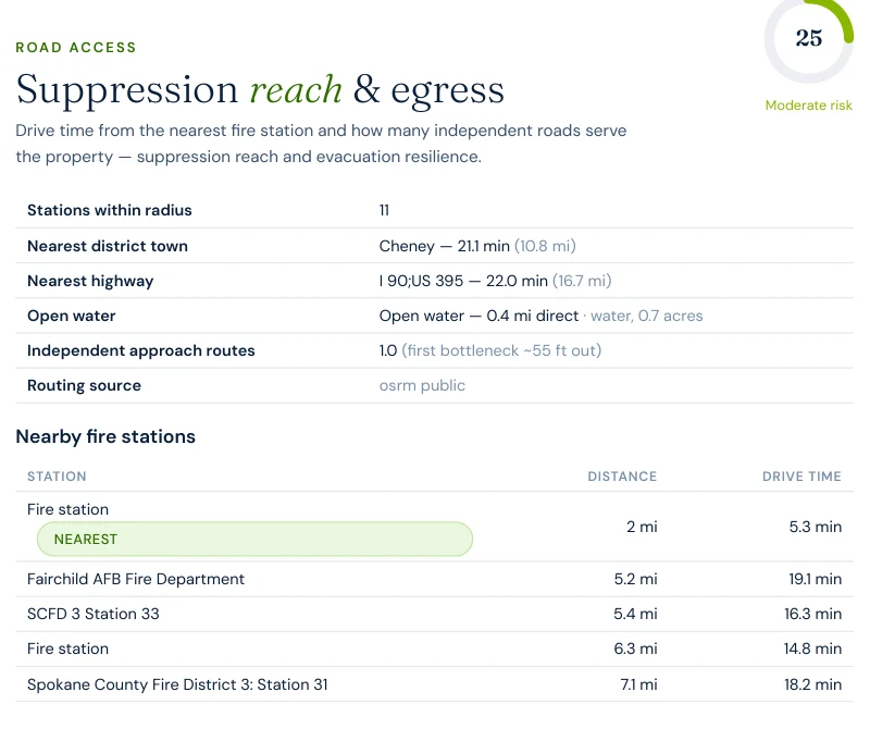
At our South Salnave Road case-study address the road-access layer reads 25 / 100:
the nearest mapped engine is a healthy 5.3 modelled minutes away, but the
parcel has one independent approach route, its first bottleneck just
~55 feet from the property, and the nearest highway — I-90/US-395 — is
3.9 miles away in a straight line and 16.7 miles, a modelled 22 minutes, by road.
A town with 25 ways out, made of streets with one.
Report excerpt — Suppression reach & egress, Satelife property report,
South Salnave Road (12 August 2026). One approach route; the nearest highway is 3.9 miles
direct and 16.7 miles by road.
What 2023 proved is that the constraint here is not the town's exits. It is time: the Gray
Fire crossed from ignition to town edge in hours, on wind — and on streets like this one,
the first minutes of that window belong to a single lane.
Exposure
The map reads your lawn. History reads your town.
Here is the tension that makes a Spokane County score worth reading layer by layer.
Washington publishes no fire-hazard-severity zone map, so the hazard layer — 30% of the
composite, its heaviest weight — is backfilled from the USFS Wildfire Risk to Communities
model. At our Medical Lake parcel that model reads 25 / 100 — Moderate,
because the pixel it samples is developed ground: streets and rooftops, not fuel.
The fire-history layer reads the same address at 90 / 100 — Very High,
because four mapped perimeters have reached the surrounding area in twenty years, the Gray
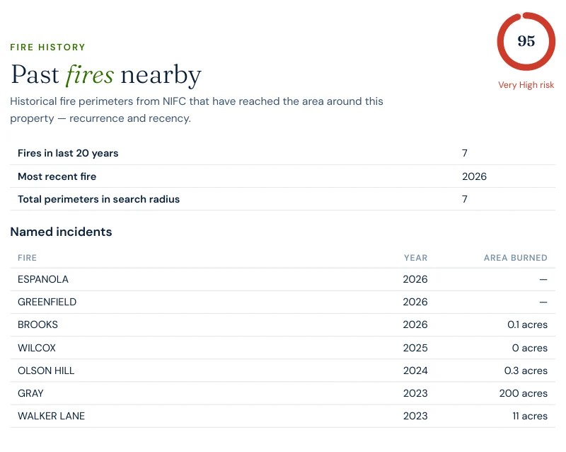
Fire among them. At community scale the layer reads 95 / 100, with
seven perimeters — three of them from 2026: Espanola, Greenfield and Brooks,
this month's fires, already in the certified data. A model of what should burn says
"moderate"; the record of what has burned says "again and again".
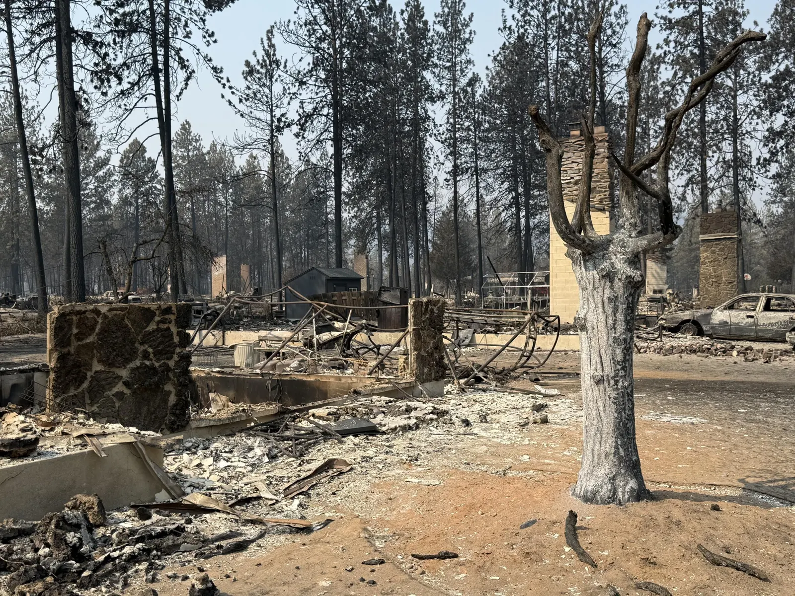
What "the fire reached town" means: a neighborhood inside the Old Trails Fire scar,
Spokane County, August 2026. Source: U.S. Forest Service, via
Wikimedia Commons
(public domain).
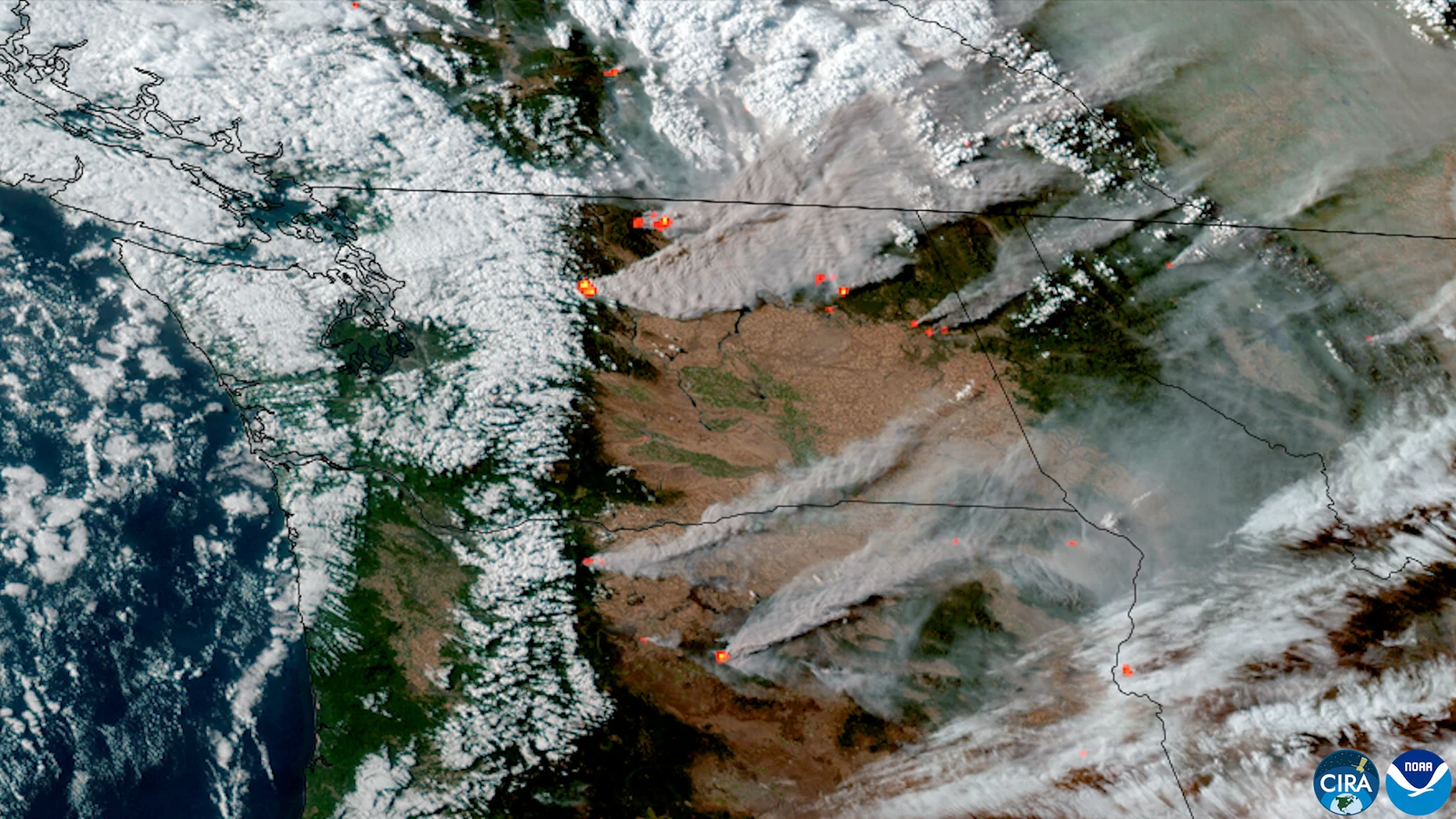
The 2026 season from orbit: GOES view, 3 August 2026 — hotspots and smoke across eastern
Washington, with the Spokane-area fires among them. Source: CSU/CIRA & NOAA, via
Wikimedia Commons
(public domain).
A hazard model samples the pixel you live on. Fire history samples the town you live in.
In Spokane County the pixel is a lawn and the town has burned three times since 1991 —
which is why the report's heaviest layer reads 25 and its loudest one reads 90.
Case study
One address on South Salnave Road, scored this week
We ran a full Satelife wildfire-risk report for a property on South Salnave Road,
Medical Lake WA 99022 — the road out of town toward Clear Lake, on the southwest side
where the Gray Fire arrived. The composite: 49 / 100 — Moderate tier, at 0.74
confidence — and, as in Travis County, the headline is the least interesting number on the
page.
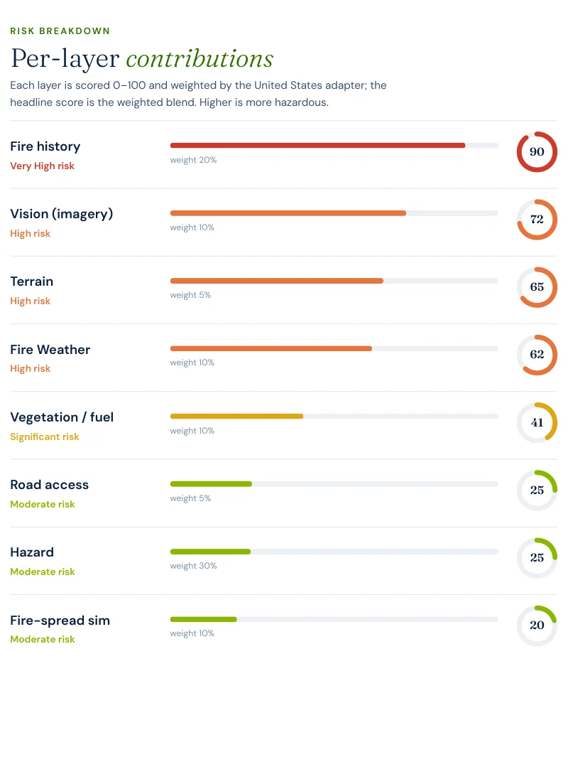
Report excerpt — Per-layer contributions, Satelife Wildfire Risk Report,
South Salnave Road, Medical Lake WA 99022 (12 August 2026). Composite 49/100, Moderate tier,
scored under the United States (usa_generic) adapter.
What drives the score:
Fire history: 90/100, weight 20% — the report's strongest signal. Four
mapped perimeters within the search radius in twenty years, the 2023 Gray Fire among them,
with the most recent in 2025.
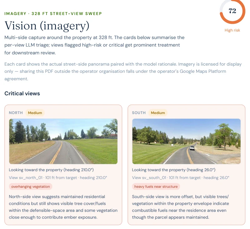
AI vision analysis: 72/100. The model reads the parcel's own aerial and
street-level imagery: a maintained suburban setting, but mature tree canopy near or partly
over the residence and ornamental vegetation inside the defensible-space envelope, flagged
as ember-catchment risk on multiple sides.
Road access: 25/100. Eleven mapped stations and a 5.3-minute nearest
engine — but one independent approach route, its first bottleneck ~55 feet from the parcel,
and a highway that is 3.9 miles away in a straight line and 16.7 miles by road.
Hazard: 25/100 at weight 30%. Backfilled from the USFS Wildfire Risk to
Communities model because Washington publishes no hazard-zone map; the sampled pixel is
developed ground. Carrying the report's heaviest weight at its second-lowest value, it is
the main reason the composite is 49 and not 65.
Report excerpt — Fire history, Satelife community report, Medical Lake
city boundary (12 August 2026). Seven perimeters in twenty years; the top three rows are
this month's fires.
Report excerpt — AI vision sweep, Satelife property report, South Salnave
Road (12 August 2026). North approach flagged for overhanging vegetation; south for heavy
fuels near the structure.
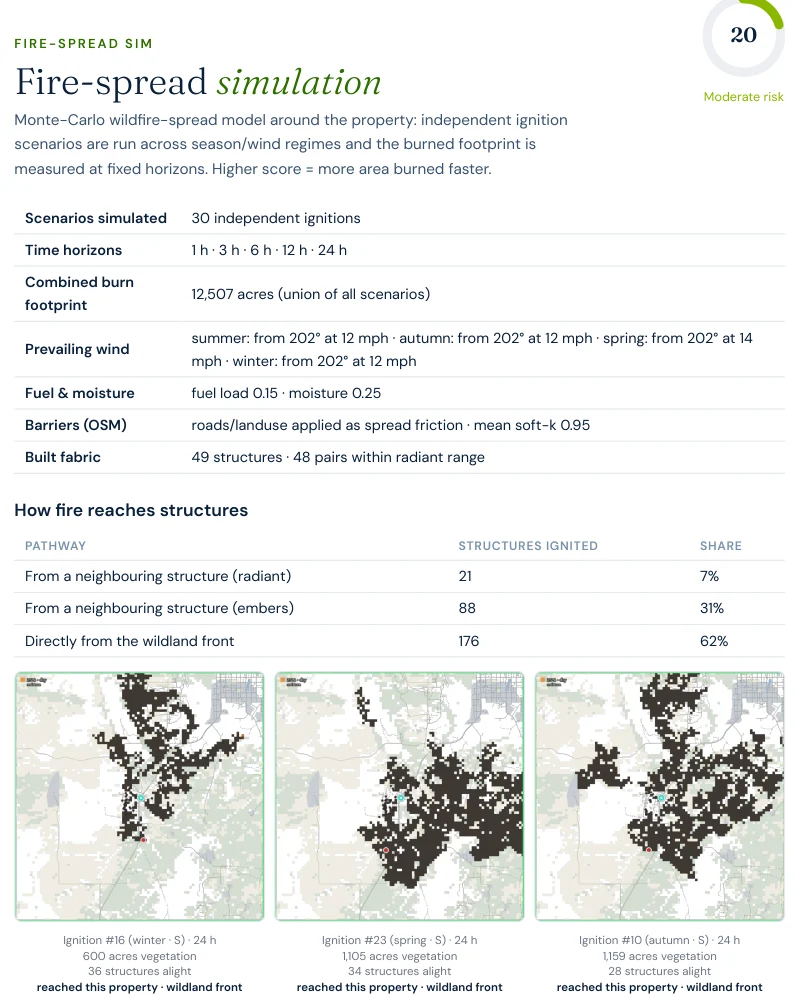
Report excerpt — Fire-spread simulation, Satelife property report, South
Salnave Road (12 August 2026). Thirty modelled ignitions, a combined 12,507-acre footprint;
62% of modelled structure ignitions come directly from the wildland front, and another 38%
travel structure to structure once fire is in town.
A parcel the hazard model calls Moderate, on a one-lane approach, in a town fire has entered
three times in three years of data. The report's mitigation plan reads like it was written by
the road-access table: extend Zone 2 fuel reduction on the north side, audit defensible space
annually — and verify access-route width and gate clearance, which on South Salnave Road is
not boilerplate but the ~55-foot bottleneck, restated at the scale of a driveway.
Insurance & real estate
After three fire years, the market is moving
Wildfire-related non-renewals in Washington more than doubled between 2021 and 2025 — from
11,763 to 24,106 homeowners — and enrolment in the Washington FAIR Plan, the
state's insurer of last resort, has grown more than 200% in five years. Carriers increasingly
price from third-party wildfire risk scores that can flag whole ZIP codes, which means
Spokane County owners can face non-renewal on modelled risk even where their own parcel never
burned. After the August 2026 fires the insurance commissioner issued an emergency order —
in effect 3 August through 30 September 2026 — restricting cancellations and non-renewals in
ZIP codes with fire losses or evacuation orders.
The structural answer is moving through the legislature: Senate Bill 6079,
passed by the Senate in February 2026, would create the Strengthen Washington Homes program —
state-funded retrofits to the IBHS Wildfire Prepared Home standard, with
certified homes protected from wildfire-related non-renewal. That makes documented,
parcel-level condition the currency of the next underwriting cycle, in exactly the way a
Satelife report's vision layer and mitigation plan are built to record.
On the real-estate side, Washington's Form 17 seller disclosure asks about many conditions —
but there is no wildfire hazard designation to disclose, because the state does not yet
publish one. Until the SB 6120 hazard mapping arrives, wildfire diligence on a Spokane County
purchase is commissioned, not looked up.
Sources: Washington Office of the Insurance Commissioner · Washington FAIR Plan ·
Stateline / Spokesman-Review reporting, August 2026 · SB 6079, SB 6120 (Washington State
Legislature) · RCW 64.06 (Form 17).
Risk reduction
What Spokane County homeowners can actually do
The report's mitigation plan for our Medical Lake parcel is concrete: extend Zone 2 fuel
reduction on the north side, audit defensible space annually before fire season, and verify
access-route width and gate clearance on the one approach the parcel has. In ponderosa
parkland that work has outsized value — the fuel is grass and needle litter, and it responds
to a string trimmer in a way a juniper canyon does not. The county has the infrastructure to
help: Wildfire Ready Neighbors, Washington DNR's free home-assessment
program, operates in Spokane County, and the local fire districts — Spokane County Fire
District 3 among them — run community-preparedness programs sharpened by three fire years in
a row.
Against our other county pages, Spokane County rhymes with
Travis County, Texas —
and then diverges. Both case-study parcels sit on constrained approaches: Steiner Ranch scored
27 / 100 with no mapped fire history and road access at 45; Medical
Lake scores 49 / 100 with fire history at 90, road access at
25, and one approach route with a bottleneck 55 feet out. The difference is what the record
says: around Steiner Ranch the national perimeter set is empty, while around Medical Lake it
holds seven fires in twenty years. And the town-scale story diverges too — Lakeway's network
narrows to a single measured pinch, while Medical Lake's 25 exits carry no single point of
failure at all. Here the town is fine and the street is the problem. A zone map, if either
state had one, would say nothing about any of it.
Coverage
ZIP codes we cover in Spokane County
Satelife runs address-level wildfire reports across every ZIP code in Spokane County.
The ZIPs below are the ponderosa pine Wildland-Urban Interface and the 2023–2026 burn footprints
communities we are asked about most. One caveat that is the whole point of what we
do: the risk score is computed for your parcel, not the ZIP, so two
homes on the same street can land in different tiers. Find your area, then
run your address.
ZIP code
Community
Why it is on the map
99022
Medical Lake
Case-study town; Gray Fire footprint on three sides
99014
Four Lakes
Gray Fire crossed I-90 here in 2023
99001
Airway Heights
West Plains grass-and-pine interface
99004
Cheney
University town ringed by channeled-scablands fuel
99009
Elk
Oregon Road Fire, 2023 — 384 structures lost
99003
Chattaroy
Little Spokane pine corridor, north county
99026
Nine Mile Falls
Suncrest ponderosa WUI along Long Lake
99021
Mead
North Spokane edge; 2026 Old Trails Fire area
99006
Deer Park
Timbered plateau between Spokane and Loon Lake
ZIP areas per USPS. Washington publishes no statewide fire hazard severity zone map; WUI framing per Washington DNR, whose SB 6120 hazard and risk mapping is in development. Scores are per-parcel, not per-ZIP.
Frequently asked questions about Spokane County wildfire risk
Is my house in a fire zone in Spokane County?
Washington publishes no statewide fire hazard severity zone map, so there is no official zone to look your address up in. The state is building one — Senate Bill 6120 directed the Department of Natural Resources to develop wildfire hazard and risk mapping — but it is not an address lookup today. Satelife reports say this explicitly on their hazard page: outside California the hazard layer is backfilled from the U.S. Forest Service Wildfire Risk to Communities model. For a property-level answer — fire history, fuels, evacuation geometry and an AI read of your actual parcel imagery — run an address-level report.
What happened in the Gray Fire?
On 18 August 2023, sparked by a faulty utility light, the Gray Fire started just southwest of Medical Lake and burned 10,085 acres in and around the town, crossing Interstate 90 near Four Lakes. It destroyed 240 structures and killed one person, with damage estimated at $60 million. The same day, the Oregon Road Fire near Elk in the north of the county burned 10,817 acres and 384 structures, 126 of them primary residences, also killing one person. Two towns, one day, both fires wind-driven through ponderosa and grass.
Are the August 2026 Spokane fires reflected in Satelife reports?
Yes. Our Medical Lake community report, generated on 12 August 2026, already lists three 2026 perimeters — Espanola, Greenfield and Brooks — in its fire-history table alongside the 2023 Gray Fire. The Old Trails, Autumn Lane and Fairview fires that broke out on 1 August 2026 burned into Spokane-area neighborhoods, destroyed or damaged over 900 structures combined by early-August counts, and forced some 67,000 people to evacuate. Fire history is the heaviest signal in both of our Spokane County case-study reports.
Will my insurance drop me after the Spokane fires?
The pressure is real. Wildfire-related non-renewals in Washington more than doubled between 2021 and 2025, from 11,763 to 24,106 homeowners, and enrolment in the Washington FAIR Plan — the insurer of last resort — has grown more than 200% in five years. After the August 2026 fires the state insurance commissioner issued an emergency order, in effect 3 August to 30 September 2026, restricting cancellations and non-renewals in ZIP codes with burned structures or evacuation orders. Senate Bill 6079, passed by the state Senate in February 2026, would fund retrofits to the IBHS Wildfire Prepared Home standard and protect certified homes from wildfire-related non-renewal. Dated, parcel-level evidence of your property’s condition is exactly what those conversations run on.
When is wildfire season in Spokane County?
The destructive window is late July through early October, and the county’s worst days share one shape: wind. The 1991 Firestorm was an October event — 92 fires in one day on winds gusting to 62 mph after 42 rainless days. The Gray and Oregon Road fires ignited on the same August afternoon in 2023. The Old Trails, Autumn Lane and Fairview fires all broke out on 1 August 2026 and grew east on sustained winds. Fires here are measured in hours, not weeks.
Scores and evacuation figures on this page are drawn from Satelife wildfire-risk reports
generated on 12 August 2026 under the United States (usa_generic) adapter: a property report for
South Salnave Road, Medical Lake WA 99022 (run 0e22859e — a complete rerun of an earlier
same-day run whose road-access layer degraded), and a community analysis of the Medical Lake
city boundary (run 1ea14a49). Washington publishes no statewide fire-hazard-severity map, so the
hazard layer is backfilled from the USFS Wildfire Risk to Communities model; the WRC
burn-probability map panels were unavailable in these runs (the point read behind the hazard
score succeeded), so flame-length probabilities are not quoted. Drive-times are modelled on
OSM-mapped stations and the current road graph and are not dispatch times. Fire figures for the 1991, 2023 and 2026
incidents come from Washington DNR, NIFC/WFIGS and contemporaneous reporting; the August 2026
fires were still in containment as this page was written and their totals may change. Satelife
reports are informational decision support — not a substitute for official evacuation orders,
state or federal hazard determinations, or an insurer's underwriting judgement.
What does your parcel look like, layer by layer?
If you own or are buying in Spokane County — Medical Lake, Cheney, Nine Mile Falls, Mead, Elk or the West Plains — get the address-level answer: PDF, per-layer score, and a prioritized mitigation plan you can hand to your insurance agent.