Wildfire risk in Mealhada: a four-century-old forest in a sea of eucalyptus
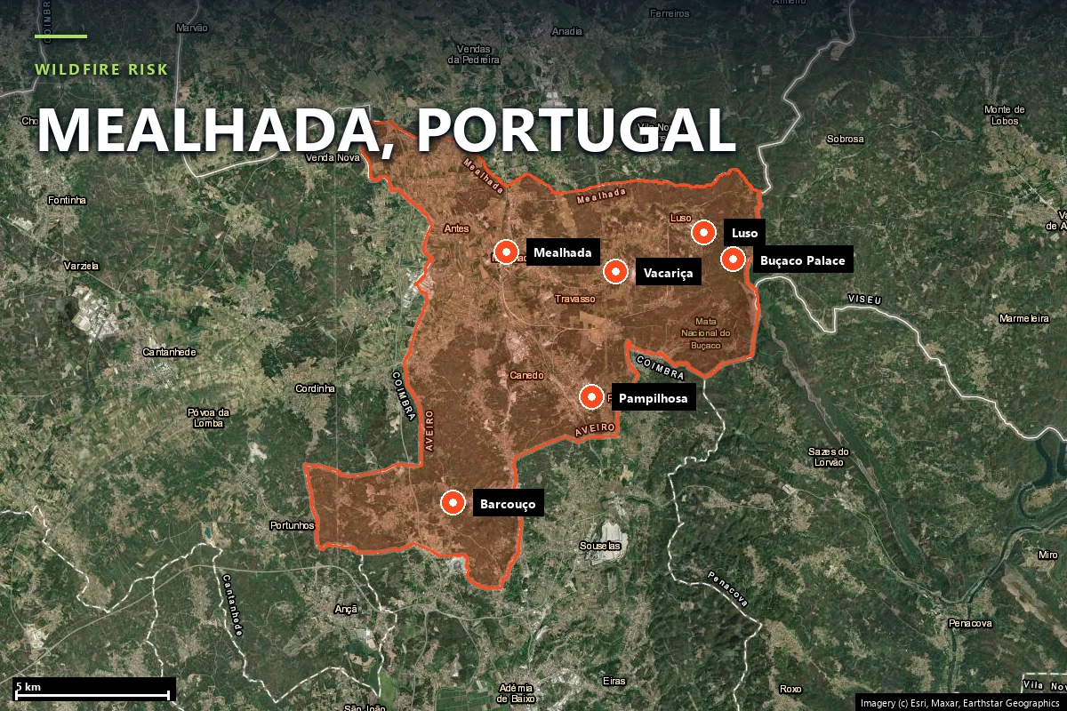
Mealhada is 110 km² of Bairrada between Coimbra and Aveiro, home to 19,348 people, the
walled Buçaco forest, the spa town of Luso and the Bairrada vineyards. Today
57% of the municipality is forest and 36.6% is eucalyptus
alone. Since 1990 about 2,410 hectares have burned inside it — three quarters
of that in August 2016 and August 2017 — and a 2016 fire stopped
634 metres short of the Buçaco wall. Our Satelife report for the Palácio
Hotel do Buçaco scores it 69.8 / 100 — band “review”, driven by fire history
(90) and a fire-spread simulation in which every modelled ignition reached it
(96).
Mealhada sits on the boundary between two landscapes: the Bairrada lowland of vineyards and
farmland to the west, and the Serra do Buçaco, which rises to 549 metres on
the municipality's eastern edge. Mealhada became a city in 2003; Luso has been a vila since
1937 and Pampilhosa, whose station is the junction of the Linha do Norte and the Linha da
Beira Alta, since 1985. Since the 2025 parish restoration the municipality again has eight
freguesias — Antes, Barcouço, Casal Comba, Luso, Mealhada, Pampilhosa, Vacariça and Ventosa
do Bairro.
1628 — the Carmelite "Desert". Discalced Carmelites founded a hermitage on
the ridge and walled roughly 105 hectares with about 5 km of stone. Its
trees have been protected from felling since 1643, and the forest now holds
about 250 tree and shrub species, the Mexican cypress known locally
as cedro-do-Buçaco the most abundant among them.
1852 onwards — Luso, the spa. The society that became the Sociedade da Água
de Luso was founded in 1852 around a spring that emerges at about 28 °C, and the railway
brought visitors from Mealhada station by stagecoach.
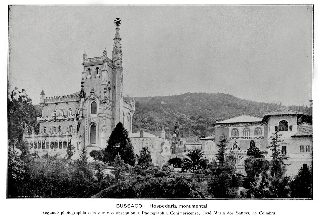
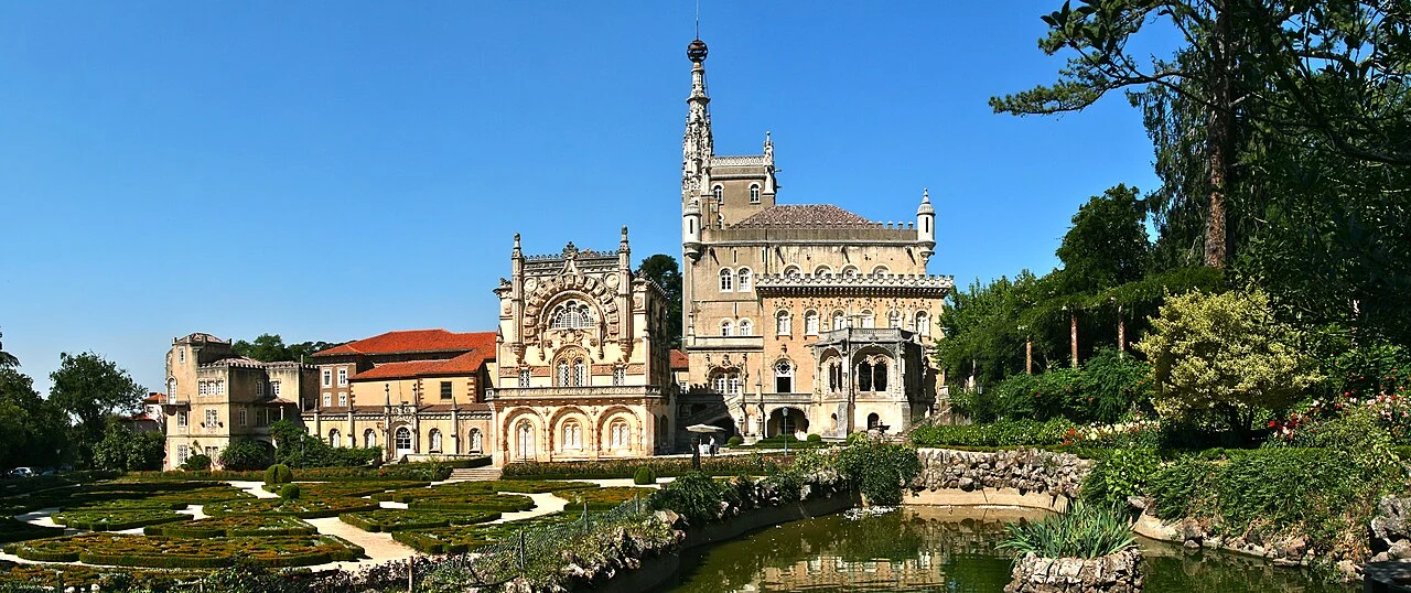
1888–1907 — the Palace Hotel. Luigi Manini's neo-Manueline palace, built
inside the forest and later a hotel, is our case-study address. The ensemble has
been on UNESCO's Tentative List since 2017 and a National Monument since 2018.
The Buçaco "hospedaria monumental" around 1900, with the forested ridge behind it.
Photograph: José Maria dos Santos, via
Wikimedia Commons
(public domain).
The same building today — the Palace Hotel with its gardens, forest on every side. Source:
François Philipp, via
Wikimedia Commons
(CC BY 2.0).
The forest's modern threats have mostly been wind, not fire. Storm Gong in January 2013
seriously damaged more than 40% of it; Storm Leslie on 13–14 October 2018 brought down
hundreds of trees, stranded 60 people at the Palace Hotel and caused about €0.5 million in
losses. Leslie is the only recorded activation of Mealhada's municipal emergency plan. Each
storm opened gaps that invasive Acacia has moved into — which matters for fire,
because acacia regenerates aggressively after disturbance.
Sources: Fundação Mata do Buçaco (fmb.pt) · UNESCO World Heritage Tentative List, ref. 6227 ·
Sociedade da Água de Luso · Município da Mealhada, Plano Municipal de Emergência de Proteção
Civil (2024) · Observador (Leslie, November 2018) · Censos 2021 (INE, via CIM Região de Coimbra).
Vegetation & fuel
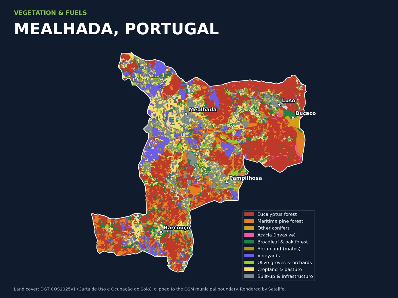
Eucalyptus is a third of the map
We clipped every polygon of DGT's newest land-cover map, COS2025, to
Mealhada's municipal boundary. Forest covers 57.3% of the municipality
(6,304 ha), agriculture 28.6% and built-up land 11.7%. Inside the forest the picture is
unusually uniform:
36.6%of the municipality is eucalyptus forest — 4,028 ha
12.9%maritime pine forest — 1,422 ha
~86%of all forest is eucalyptus or maritime pine
10.4%vineyards — 1,146 ha of Bairrada DOC
Mealhada by land cover, COS2025. Eucalyptus (red) runs almost unbroken from Luso to
Barcouço; the Bairrada vineyards and cropland hold the west around the town. The Buçaco
forest shows up as the odd patch out — other conifers and broadleaf, not eucalyptus. Data:
DGT COS2025v1, clipped to the OSM municipal boundary; rendered by Satelife.
Eucalyptus and pine plantations are Portugal's classic fast-fire fuels: continuous canopy over
litter and shrub, often on small, fragmented and sometimes unmanaged private holdings.
Mealhada's own 2011 fire-defence plan (PMDFCI) found forest-litter fuel (model 9) on 39% of
the territory and warned that farmland abandonment and the monoculturização of the
forest in pine and eucalyptus were removing the buffer zones between them. The older COS2018
map put eucalyptus at 34.1%; the two maps differ in method, so read the change as direction,
not a precise rate.
Buçaco is the counter-example. Its relic forest is oak (Quercus robur,
Q. pyrenaica), laurel with strawberry tree and holly, and a unique formation of
large Phillyrea latifolia, under a humid, foggy, mostly north-facing microclimate. The
Fundação Mata do Buçaco's 2023 fire plan flags the problem at the wall rather than inside it:
eight areas of about 300 hectares within 1 km of the Mata, around
90% eucalyptus, mostly private.
The same map drives the report. Within 100 metres of the Palace Hotel, COS2025 is
92% built — the palace, its gardens and outbuildings — so the parcel's own
fuel reading is a low 25. But the report also looks outward, and in all eight compass
directions forest begins about 200 metres away, which lifts the vegetation
layer to 43 / 100. A clearing inside a forest is still inside the forest.
The terrain adds relief rather than extremes. The Palace Hotel sits at
379 metres (Copernicus DEM, terrain layer 55 / 100), below a
ridge whose slopes face mostly north and north-west — the aspect the forest's managers credit
for its moisture.
Sources: DGT COS2025v1 and ICNF COS2018 (clipped by Satelife to the municipal boundary) ·
Município da Mealhada, PMDFCI Caderno I v1.1 (2011) · Fundação Mata do Buçaco, flora pages
and Plano Estratégico de Prevenção de Incêndios Rurais da MNB (2023).
Fire record
2,410 hectares since 1990, most of it in two Augusts
ICNF, the national forest and conservation institute, publishes every mapped burned area in
Portugal back to 1975. Clipping the 1990–2025 perimeters to Mealhada gives the municipality's
own record. It is not a place that burns every year — the 2011 fire plan called it
"many ignitions, little area burned" — but when it burns, it burns big:
~2,410 haburned inside Mealhada, 1990–2025 (ICNF)
961 hain 2017 alone — about 8.7% of the municipality
834 hain 2016, most of it in Luso
634 mclosest mapped approach of fire to the Buçaco forest (2016)
10–14 August 2017 — Barcouço. Ignited at 12:33 on 10 August in Murtede
(Cantanhede), cause recorded as intentional. It burned about 1,200 ha in total,
817 ha inside Mealhada, closed the A1 in both directions for almost nine
hours and rekindled "with great intensity" the next day. Some 405 personnel and 122 vehicles
were deployed.
10–19 August 2016 — the Anadia fire. Started in Vila Nova de Monsarros and
ran south into Luso: 3,428 ha in total, 696 ha in Luso. It
threatened the village of Várzeas and, per contemporaneous reporting, came within 250 m of the
Buçaco forest's Porta da Rainha. On ICNF's perimeter it stopped 634 m from the forest boundary.
2005 — south-west Barcouço. 853 ha in total, 410 ha inside the
municipality, on the same ground the 2017 fire would reburn twelve years later.
15 October 2017. On Portugal's worst fire day in modern memory, Mealhada
recorded one local fire of about 145 ha near Ventosa do Bairro; the A1 was closed north of
Mealhada by fires elsewhere. September 2024: no mapped burned area inside
the municipality, though the district burned to the north.
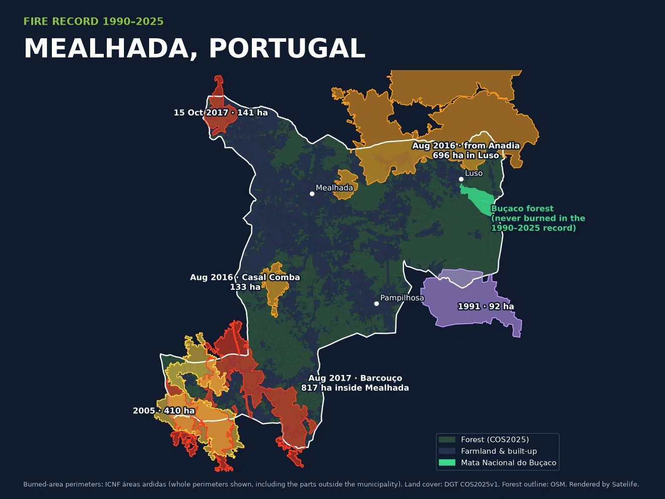
Thirty-five years of burned area around Mealhada. The south-west corner around Barcouço
burned in 2005 and again in 2017; the 2016 Anadia fire came down into Luso and stopped short
of the Buçaco forest (green). Whole perimeters are drawn, including their parts outside the
municipality. Data: ICNF áreas ardidas; land cover DGT COS2025v1; rendered by Satelife.
Sources: ICNF áreas ardidas 1990–2025 (sigservices.icnf.pt, clipped by Satelife to the
municipal boundary; areas are within about 1% of ICNF's own figures) · Público, Diário de
Notícias and Bairrada Informação (August 2017) · SIC Notícias, RTP and Visão (August 2016,
July 2018) · Município da Mealhada, PMDFCI (2011).
Hazard & fire weather
One fifth of the municipality is high hazard
Portugal does publish an official structural hazard map: ICNF's Carta de Perigosidade
de Incêndio Rural (CPIR) 2020–2030. Reading its classes over Mealhada, we find
19.5% of the municipality in alta (high) and 0.9%
in muito alta (very high), with a further 17.9% in média. Inside the Buçaco
forest the map reads 64% medium and 24% high — lower than the eucalyptus ridge around it, and
lower than the 2011 municipal plan, whose older map put the Mata in the high and very-high
classes.
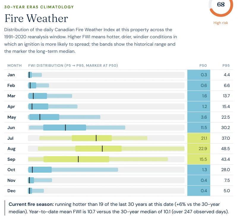
The weather decides when that hazard turns into fire. Satelife's fire-weather layer reads
thirty years (1991–2020) of daily Canadian Fire Weather Index from the ERA5 reanalysis at the
Buçaco grid cell and scores it 68 / 100. The season is sharply Iberian:
median FWI is below 4 from October to May, climbs to 11.5 in June, and peaks at
22.9 in August, when the 95th-percentile day reaches 48.5.
September stays dangerous (p95 43.4) — both big local fires were August events. On the day the
report ran, the 2026 season was tracking hotter than 19 of the last 30 years.
Report excerpt — Fire weather, Satelife property report, Palácio Hotel do
Buçaco, Luso (25 September 2026). Thirty-year ERA5 climatology of the Fire Weather Index,
month by month.
Coimbra's IPMA station, 20 km south, averages 866 mm of rain a year with August highs of
28.6 °C and a record of 41.6 °C: wet winters that grow fuel, and dry summers that cure it.
Sources: ICNF CPIR 2020–2030 (perigosidade estrutural; class shares computed by Satelife over
the municipal boundary) · Satelife property report run d333d755 (ERA5 via Open-Meteo, CC BY
4.0) · IPMA climate normals 1991–2020, Coimbra.
Case study
The Palácio Hotel do Buçaco, scored this week
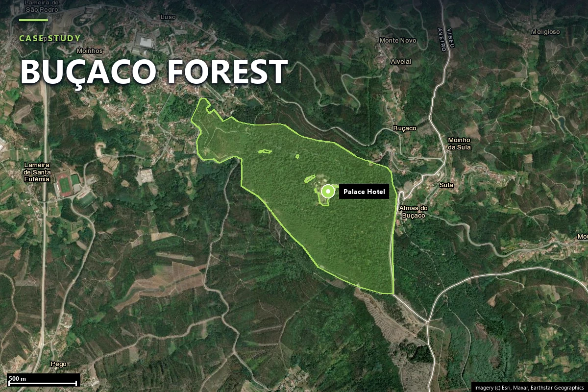
We ran a full Satelife wildfire report for the Palácio Hotel do Buçaco, inside
the walled forest above Luso, and a community-scale report for the town of
Mealhada (its 993-hectare parish boundary, gridded into 404 analysis zones). The
palace scores 69.8 / 100, in the “review” band, at 0.86
confidence — Portuguese reports are an exposure score for operational decision support, and
“review” is the band that asks for a closer look before the next fire season.
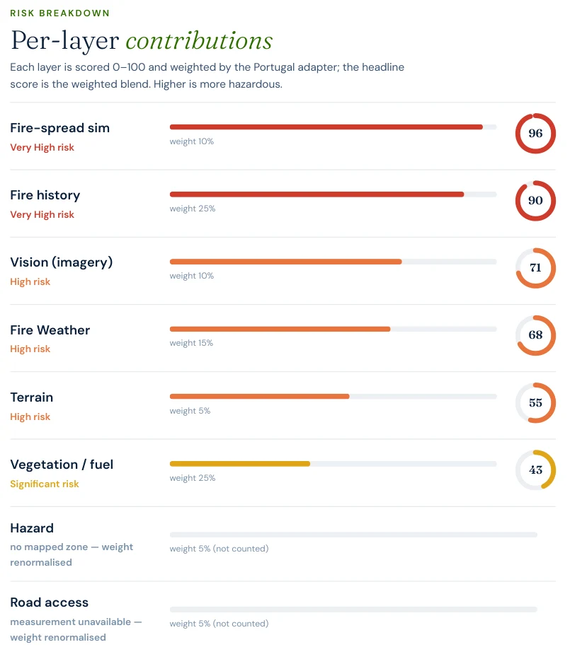
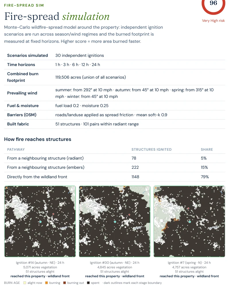
Fire-spread simulation: 96 / 100. Thirty modelled ignitions, placed upwind
of the palace for each season's wind, burn across a fuel grid built cell by cell from COS2025
— 85% of the surrounding 5 km square is forest. All 30 reached the property;
79% of the structure ignitions in the model come directly from the wildland front.
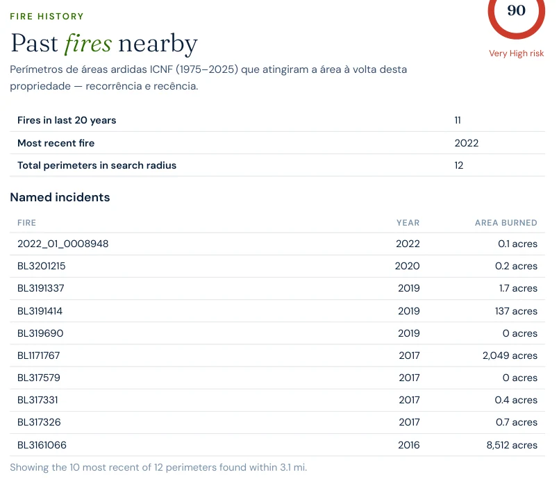
Fire history: 90 / 100, weight 25%. Twelve ICNF perimeters within 5 km,
eleven in the last twenty years, the most recent in 2022 — led by the 2016 Anadia fire and a
2017 fire of 829 ha. The Mealhada town report reads the same layer at 90.
AI vision: 71 / 100. From street-level imagery around the palace: tree and
shrub fuel inside the defensible-space envelope, with only partial separation between the
buildings and the vegetation.
Fire weather: 68 / 100, the August-peaking ERA5 climatology above, and
terrain 55 at 379 metres on the ridge's northern flank.
Vegetation: 43 / 100 — a built clearing, ringed by forest at ~200 m.
Report excerpt — Fire-spread simulation, Palácio Hotel do Buçaco
(25 September 2026). The three worst of thirty scenarios; each reached the palace from the
wildland front.
Report excerpt — Fire history, Palácio Hotel do Buçaco (25 September
2026). ICNF perimeters within 3.1 miles (5 km); the report lists areas in acres — 8,512
acres is the 3,444-ha 2016 Anadia fire.
Access to the palace. In a complete read the same day, the report timed the
nearest mapped station, the Bombeiros Voluntários da Mealhada, at 13.9 minutes
(11.6 km by road) — Luso has no corps of its own — with six stations inside 15 km, and found
the palace's approach routes converging about 26 metres out.
The town of Mealhada, zone by zone
The community report grids the town's 993-hectare parish into 404 zones and
scores each on its own land cover (COS2025) and its own fire record (ICNF perimeters within
about a kilometre), alongside the town-wide terrain, fire weather and access. The town as a
whole scores 45.0 / 100, band “monitor”; zones run from
35 in the built centre to 57 on the edges, and every one of
the highest-scoring clusters is driven by vegetation — the eucalyptus and pine that press in on
the town from the east.
45.0 / 100Mealhada town, band “monitor” — zones from 35 to 57
14independent road exits for 1,120 mapped buildings — 80 per exit
3.4 minmodelled drive from the Bombeiros Voluntários da Mealhada; 2.3–5.5 min to the three highest-scoring zones
919of 1,120 buildings stand less than 5 m from their neighbour
The last number is the town's own exposure: a dense, terraced core in which fire, once inside,
travels building to building. The first approach routes converge about 15 metres from the
analysis centre, and drive-times are modelled on mapped stations and the current road graph,
not dispatch times.
A palace in a clearing reads as “built” on its own parcel. The score comes from what surrounds
it: forest at 200 metres on every side, eleven fires in twenty years within 5 km, and a
simulated fire that reached it thirty times out of thirty.
Risk reduction
What owners in Mealhada are required to do
Portugal's rural-fire law, Decreto-Lei 82/2021, puts the first line of
defence on the owner: fuel must be managed in a 50-metre strip around
buildings in rural areas, and a 100-metre strip is required around settlements.
ICNF has listed Luso among its priority parishes for fuel-management
enforcement every year from 2019 to 2025, and Vacariça in 2019. In practice, in Mealhada that
strip is very often eucalyptus — and the 2023 Buçaco fire plan's 300 hectares of mostly
private eucalyptus around the Mata is the same problem at the scale of a national monument.
The palace report's own plan starts where the model does: extend fuel reduction on the north
side, where the highest-ranked wildland approach begins about 200 metres out; coordinate ember
and radiant hardening with the neighbouring buildings; verify the 50-metre strip; and re-scan
before the June–October season.
A property report turns the rule into a plan: it shows which fuel sits where around a specific
building, how far away, upwind or downwind of the summer west-north-westerly and autumn
north-easterly wind regimes the report models, and what the ICNF record says about the ground around it. For a Palace Hotel or a
terraced house in Luso, the answer is different — which is exactly why it is computed per
address.
Against our American pages, Mealhada rhymes with
Spokane County, Washington:
both case studies read fire history at 90 / 100, both from towns that have
seen fire at the edge within the last decade. The difference is time to help. Our Medical
Lake community report put the fastest modelled engine at 10.5 minutes;
central Mealhada's is 3.4, with five volunteer corps inside 15 km. Mealhada's
exposure is the fuel on the ground — a third of the map in eucalyptus — rather than distance
from a fire station.
Sources: Decreto-Lei 82/2021 (Diário da República) · SGIFR, land-cleaning guidance · ICNF
FREG_PRIORITARIAS_DFCI · Fundação Mata do Buçaco (2023) · Satelife reports, Mealhada
(25 September 2026) and Medical Lake (12 August 2026).
Frequently asked questions about wildfire risk in Mealhada
How exposed is the Buçaco Palace Hotel to wildfire?
Our Satelife report of 25 September 2026 scores the Palácio Hotel do Buçaco 69.8 out of 100, in the “review” band, at 0.86 confidence. The drivers are a fire-spread simulation in which all thirty modelled ignitions reached the palace (96/100), twelve ICNF burned-area perimeters within 5 km (fire history 90/100), fuel visible around the buildings in street-level imagery (71) and an August-peaking fire-weather climatology (68). Its own 100-metre surroundings are mostly built, but forest begins about 200 metres away in every direction.
Has the Buçaco forest ever burned?
Not in the mapped record. No burned-area perimeter in ICNF’s 1990–2025 series intersects the walled Mata Nacional do Buçaco. The closest call was the August 2016 fire that started in Vila Nova de Monsarros (Anadia): it burned 3,428 hectares, 696 of them in the parish of Luso, and stopped about 634 metres from the forest boundary by our measurement — press reports at the time put the flames within 250 metres of the Porta da Rainha gate. ICNF’s 1975–1989 layer carries no geometry, so earlier fires cannot be checked the same way.
What was the worst wildfire in Mealhada?
By area inside the municipality, the fire of 10–14 August 2017. ICNF records its ignition at 12:33 on 10 August in Murtede (Cantanhede), cause intentional; it crossed into Barcouço, where 817 hectares burned, closed the A1 motorway for almost nine hours and rekindled the next day. 2017 as a whole burned about 961 hectares of Mealhada — roughly 8.7% of the municipality.
Did the October 2017 or September 2024 fires reach Mealhada?
Only marginally in 2017 and not at all in 2024. On 15 October 2017 ICNF maps a single local fire of about 145 hectares around Ventosa do Bairro, while the great complexes of that weekend burned elsewhere in the Centro region. The September 2024 fires that burned across Aveiro district — Oliveira de Azeméis, Sever do Vouga, Albergaria-a-Velha, Águeda — left no mapped burned area inside Mealhada.
How much of Mealhada is eucalyptus?
About 36.6% of the whole municipality — 4,028 hectares — is classified as eucalyptus forest in DGT’s COS2025 land-cover map, by our clip to the municipal boundary. Maritime pine adds another 12.9%. Together they make up about 86% of Mealhada’s forest, which covers 57% of the municipality. The older COS2018 map put eucalyptus at 34.1%.
What fuel-management rules apply to a house in Mealhada?
Under Decreto-Lei 82/2021, owners must manage fuel in a 50-metre strip around buildings in rural areas, and a 100-metre strip is required around settlements (aglomerados). ICNF has listed Luso as a priority parish for fuel-management enforcement every year from 2019 to 2025. A Satelife report shows where the fuel actually sits around a specific building, in which direction and at what distance.
Does Satelife cover Portugal?
Yes. Satelife runs address-level reports in mainland Portugal under a dedicated Portuguese adapter: fire history from ICNF’s burned-area archive (1975–2025), land cover from DGT’s COS map, terrain from the Copernicus DEM, a 30-year ERA5 fire-weather climatology, fire-station drive-times, fire-spread simulation and an AI read of the property imagery. Portuguese reports are framed as an exposure score for operational decision support — not an official hazard classification.
Satelife figures on this page come from reports generated on 25 September 2026 under the
Portugal adapter: a property report for the Palácio Hotel do Buçaco, Luso (run d333d755 —
composite, layers and excerpts), the road-access read from a second same-day run for the same
address (7bba6631), and a community analysis of the Mealhada town parish boundary (run
a1f18e0e). ICNF's CPIR hazard layer is not yet part of the Portuguese score, so in both reports
the hazard weight is renormalised away rather than scored. Land-cover shares were computed by Satelife from DGT COS2025v1 and
COS2018, CPIR class shares from ICNF's public raster, and the fire record from ICNF's
burned-area archive, all clipped to the OpenStreetMap municipal boundary; small differences
from official statistics are expected. Drive-times are modelled on mapped stations and the
current road graph, not dispatch times; the fire-spread simulation is a model, not a forecast.
Satelife reports are operational decision support — not an official hazard classification, a
substitute for civil-protection orders, or an insurer's judgement.
What does your building look like, layer by layer?
If you own, insure or manage property in Mealhada — Luso, Pampilhosa, Barcouço, Vacariça or the town itself — get the address-level answer: fire record, fuel around the building, fire weather and a prioritised action plan aligned with DL 82/2021.