Just past 3:30 in the afternoon on 15 July 2026, CAL FIRE’s command center started taking calls about smoke near Buckthorn Trail, in the Live Oak Springs neighbourhood of Boulevard — the high, dry backcountry at the eastern edge of San Diego County.
“We got multiple reports of a fire just past 3:30 to our command center,” CAL FIRE San Diego Captain Oscar Sotelo told reporters that evening.
Within about 45 minutes the fire had run to 236 acres and jumped Interstate 8. By 6:22 PM it had more than doubled again, to 593 acres. Six evacuation zones went out. The interstate — the only major road through this part of the county — closed in both directions. By the next morning the Thorn Fire had burned past 1,200 acres, damaged four structures, and drawn more than 600 firefighters and 90 pieces of equipment onto the line.
For firefighter paramedic Fredric Miltimore, pulling an elderly couple out of a property off a narrow dirt road as the fire turned toward them, the numbers were beside the point: “We were staring at 20-foot flames for sure.”
Nobody died. The fire is now 95% contained, the evacuation orders are lifted, and I-8 is open. The cause is still under investigation.
This post is about what made it possible — and what the same landscape looks like when you measure it, address by address, before anything is burning.
Where the Thorn Fire burned
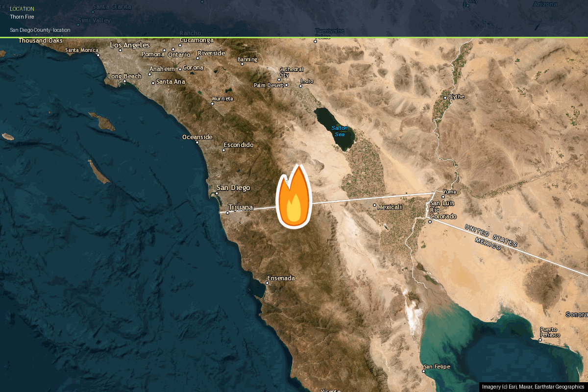
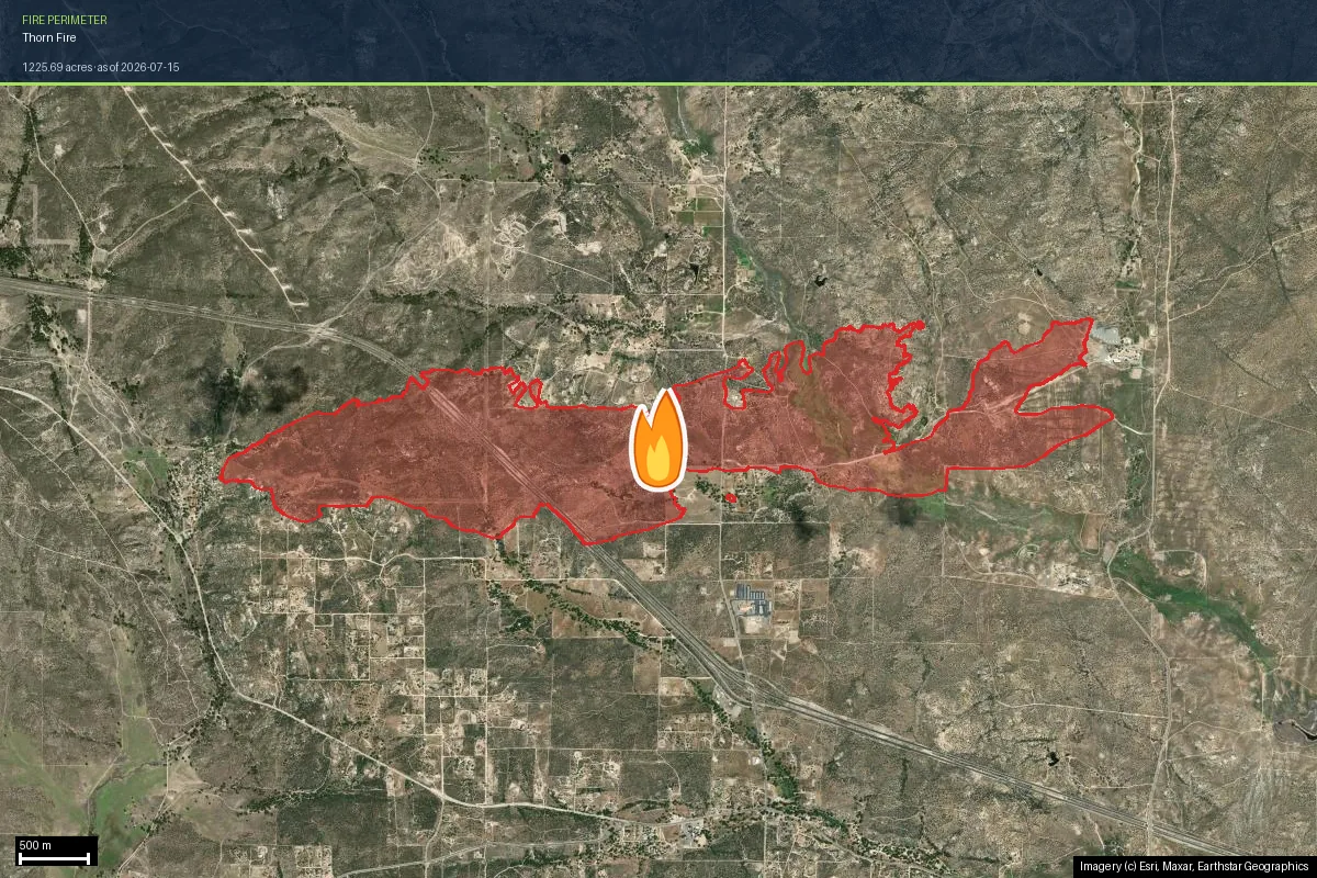
The burn sits in the Boulevard area (ZIP 91905), about 60 miles east of the city of San Diego and close to the Mexican border. This is the transition country where coastal chaparral gives way to high-desert scrub — elevations around 1,200 m, homes on large rural lots, dirt driveways, and a landscape that reads brown and open on satellite imagery for most of the year.
Look at the shape. The perimeter is a long, narrow east–west band running roughly eight kilometres, straddling Interstate 8. That shape is not decoration; it is the fire’s own record of how it moved.
| Started | 15 July 2026, just after 3:30 PM |
| Location | Buckthorn Trail and Clover Trail, Live Oak Springs, Boulevard area |
| Size | 1,234 acres (CAL FIRE) · 1,226 acres in the mapped perimeter |
| Containment | 95% |
| Cause | Under investigation |
| Structures damaged | 4 |
| Resources | 600+ firefighters · 90+ pieces of equipment |
| Evacuations | Six zones ordered, all lifted 17 July 2026 |
The preconditions: why this ground was ready to burn
No single thing causes a fire like this. Five conditions stacked, and each one is visible in public data long before an ignition happens.
1. Extreme heat sitting on cured fuel
The fire started during a regional heat wave, into hot and dry air. Chaparral in mid-July is at its annual driest — the live fuel moisture that makes spring brush hard to ignite has bled out by then. Heat does not start fires, but it decides what happens in the first fifteen minutes after one starts. Here the answer was 236 acres.
2. A landscape that is essentially all fuel
Zoom into the settlement itself and you see houses, yards and gravel — it looks managed. Widen the lens by less than a kilometre and the picture inverts completely.
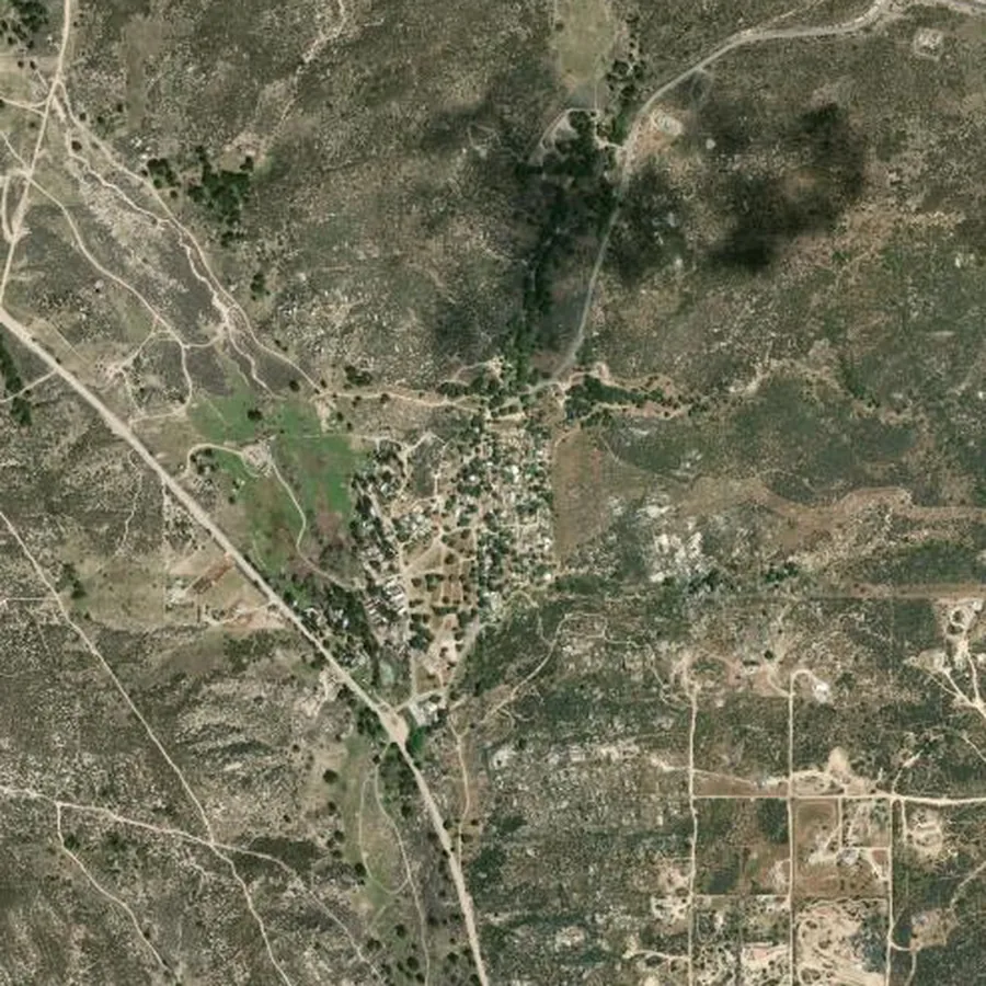
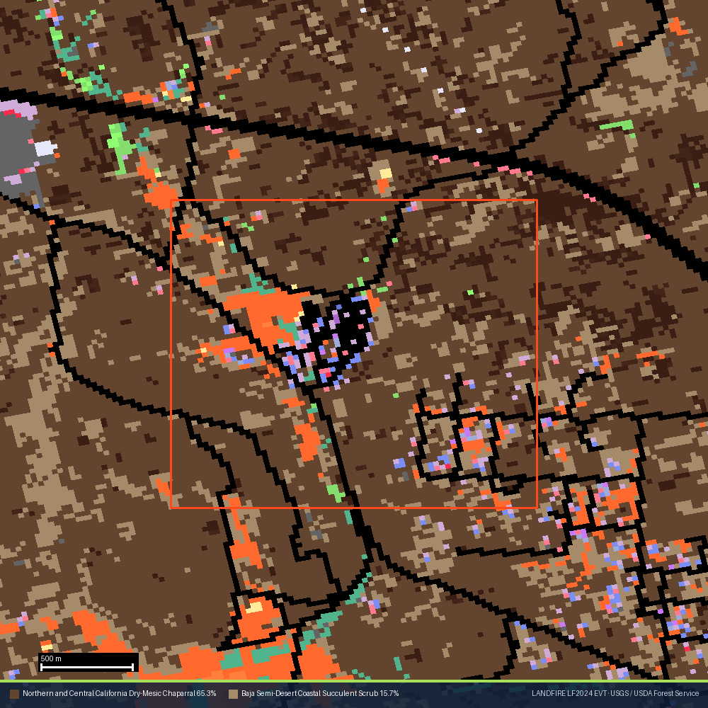
Inside a 1 km radius of the settlement, the federal vegetation map reads roughly 88% chaparral and scrub — 65% dry-mesic chaparral, 16% semi-desert succulent scrub, the rest mesic chaparral, grassland and montane woodland. The community is an island. The fuel is the sea around it.
This is the single most misread fact in wildfire risk. A tight ring drawn around a compact settlement will always report low wildland fuel — that is what a settlement is. It says nothing about the landscape delivering fire to its edge. And once fire reaches a cluster this dense, the fuel becomes the structures: homes ignite each other by radiant heat and ember cast at spacings far tighter than any defensible-space standard assumes.
3. Terrain and wind pulling in the same direction
That long, thin perimeter is the signature of a wind-driven fire. A fire spreading as a narrow band rather than a widening circle is being pushed along an axis, and the width of the band tells you how far flanking spread got before crews or fuel breaks stopped it. The Thorn Fire’s band is several times longer than it is wide, aligned east–west with the terrain here.
The practical consequence for a homeowner: proximity is directional, not radial. A house 500 m north of this perimeter and a house 500 m east of it did not face the same fire. One was on the flank; the other was in the run.
4. Ground that burns on a short cycle
This is not unlucky country — it is frequently burned country. Federal perimeter records over this area show 13 past fires, six of them in the last twenty years: Thorn and Tusil this year, Old-2 at nearly a thousand acres in 2012, and a run of smaller Church, Crestwood and Ribbonwood fires before that. Roughly one fire every three years reaches this ground.
5. One way in, one way out
The condition residents name first is the one that maps show last. Deborah Gonzales, who lives in Live Oak Springs, described the night of the evacuation:
“It was just, it was real upsetting. Nobody could move anywhere. And we only have one way in and one way out. So when the I-8 is shut down and everybody, including semis, are being detoured down 80 and where it turns into 94 — it’s, it’s bad.”
When a perimeter straddles the only major highway through a region, that road is three things at once: a fuel break, an evacuation route, and an exposure corridor. It cannot be all three at the same moment. Rural access cuts both ways — the long dirt driveway that slows an engine’s approach also slows your exit.
What the people there actually said
The data describes the setup. The people describe the experience, and the two agree more closely than you might expect.
Patti Fisher, 74, and Dan Shanahan, 70, were at home on a remote property in Tierra Heights when the fire, which had been moving away from them, shifted. Sheriff’s Deputy John Ferris and two firefighter paramedics got them out as flames reached the backyard.
“That was pretty traumatic because we were taking off at the last minute and that was really scary.” — Patti Fisher, resident
“We basically peeled out of there. It was stressful. Glad we were able to help.” — Lee Woods, firefighter paramedic
“Any fire up here is a scare.” — Audra Burgio, owner of Burgio Feed & Supply
“You have to feel comfortable yourself. And if you’re not prepared, you can’t relax.” — Daniel Chapman, Live Oak Springs resident
And the part that does not show up in any hazard model:
“This is like no other place I’ve ever lived in my life. Everybody comes together, especially during fires. Everybody. People knock on each other’s doors. They check on each other.” — Deborah Gonzales, Live Oak Springs resident
CAL FIRE credited night-flying helicopters making continuous water drops with stopping the forward spread overnight. Six hundred people worked the line to hold a fire that had doubled in size twice in three hours.
What this looks like as a property report
Those five conditions are exactly what a wildfire-risk report measures — not for a region or a ZIP code, but for one address. To show what that looks like in practice, we ran a live Satelife report on a real parcel on Live Oak Trail, in the same Live Oak Springs community the fire started in, at the western end of the perimeter.
We deliberately did not score the property at the point of origin. The cause is still under investigation, and it would be wrong to publish an address-level analysis that could read as implicating a household.
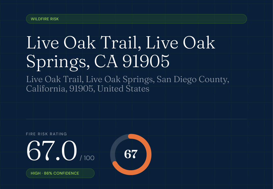
67 out of 100 — High, at 86% confidence. The number itself matters less than the three things underneath it.
Flame length. The federal wildfire model gives this location a 70% chance of flames over 4 feet if fire arrives here. Four feet is roughly the threshold above which hand crews can no longer hold a line directly — beyond it you need engines, dozers or aircraft. Fredric Miltimore, standing in it, put the number at twenty.
Community preparedness — the quiet finding. The report also researches what the community itself has in place: a Community Wildfire Protection Plan, Firewise USA recognition, local programs, drills. For Live Oak Springs it came back Moderate, 48 out of 100, and the reason is absence rather than failure. San Diego County has an active CWPP programme with more than forty approved plans and county guidelines that emphasise evacuation routes and fuel breaks. But there is no public evidence of a CWPP naming Live Oak Springs, no Firewise USA site in or next to it, and no documented local evacuation drills. County-level planning exists. Community-level planning, as far as the public record shows, does not.
Which makes Deborah Gonzales’s description of neighbours knocking on each other’s doors the most important preparedness asset this community has — and the one that exists in no plan, no budget line, and no dataset.
The actions are about the building, not the landscape.
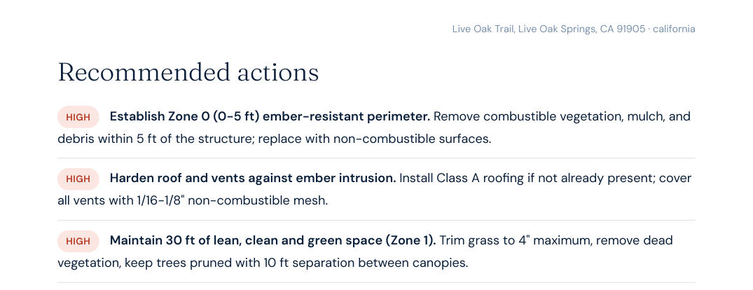
Clear the first five feet around the house, harden the roof and vents against embers, keep thirty feet lean and green. That ordering is not an accident. Four structures were damaged out of many inside that perimeter, and where a fire touches a scattering of rural parcels and destroys only a few, the difference is almost always defensible space and structure hardening.
One honest caveat: the road-access measurement failed on this run — the routing service that calculates drive time from the nearest fire station did not answer, so the engine substituted a neutral value. That is a defect on our side, and it happens to be the one thing Deborah Gonzales could have told us in a sentence.
If you live in country like this
The Thorn Fire is contained. The conditions that produced it are not — they are seasonal, and they will be back.
Work on the first five feet before anything else. Embers, not flame fronts, destroy most structures in fires like this. Non-combustible ground cover against the foundation, clean gutters and roof valleys, screened vents. This beats clearing brush at distance, and it is the cheapest thing on the list.
Know your evacuation zone code now. San Diego County issues orders by zone ID. Look yours up on a quiet evening, not while you are watching smoke.
Have a second route you have actually driven. If your community has one way in and one way out, the second route is a dirt road you need to know in the dark. Drive it once this month.
Do not read a quiet map as a safe address. A hazard zone that covers your whole county cannot tell you which side of a wind-driven run your lot sits on. Neither can a fuel reading taken 100 metres from your door in a place where the chaparral starts at 900.
Talk to your neighbours. Gonzales is describing the single best-documented predictor of how a rural community comes through a fire — and it is the one thing no satellite can measure.
Get a Satelife wildfire-risk report for your address · How we score
Incident facts: CAL FIRE.
Perimeter: NIFC/WFIGS (raw polygon).
Quotes reported by KPBS,
San Diego County News Center,
NBC 7 San Diego and
Times of San Diego.
Property score from a live Satelife wildfire_risk run, 19 July 2026. Layer sources: NIFC/WFIGS,
CAL FIRE FHSZ, USFS Wildfire Risk to Communities, USGS 3DEP, LANDFIRE LF2024, Open-Meteo ERA5, FEMA National Risk Index.
Acreage and containment change during an active incident — check the CAL FIRE page for current status.
