At 3:57 in the afternoon on Monday, 10 August 2026, Los Angeles County Fire Department crews were dispatched to a grass fire near West Avenue H and 90th Street West, on the edge of Antelope Acres — the unincorporated community of ranchettes and small farms scattered across the open floor of the western Antelope Valley, northwest of Lancaster.
By 4:15 p.m. the fire had reached 30 acres and a second alarm went out. Twenty minutes after crews arrived, a county fire spokeswoman told City News Service, it had grown to 300 acres, “prompting evacuation warnings for the surrounding area.” An hour after the first report it stood at 362 acres. Warnings went out for the area near West Avenue G and for the parcels south of West Avenue D.
And then, almost as quickly, it was over. At 6:09 p.m. the county fire department announced forward progress had stopped. The evacuation warnings were downgraded to advisories, then lifted minutes later. One firefighter suffered a minor burn to his hands; no civilian injuries and no destroyed structures were reported. The cause is under investigation.
Two hours, start to stop. It would be easy to file that under “no harm done” — except that this is the third time since May that the ground around Antelope Acres has done exactly this. This post is about the conditions that keep producing these fires, and what the same ground looks like when you score it, address by address, before anything is burning.
Where the Jarvis Fire burned
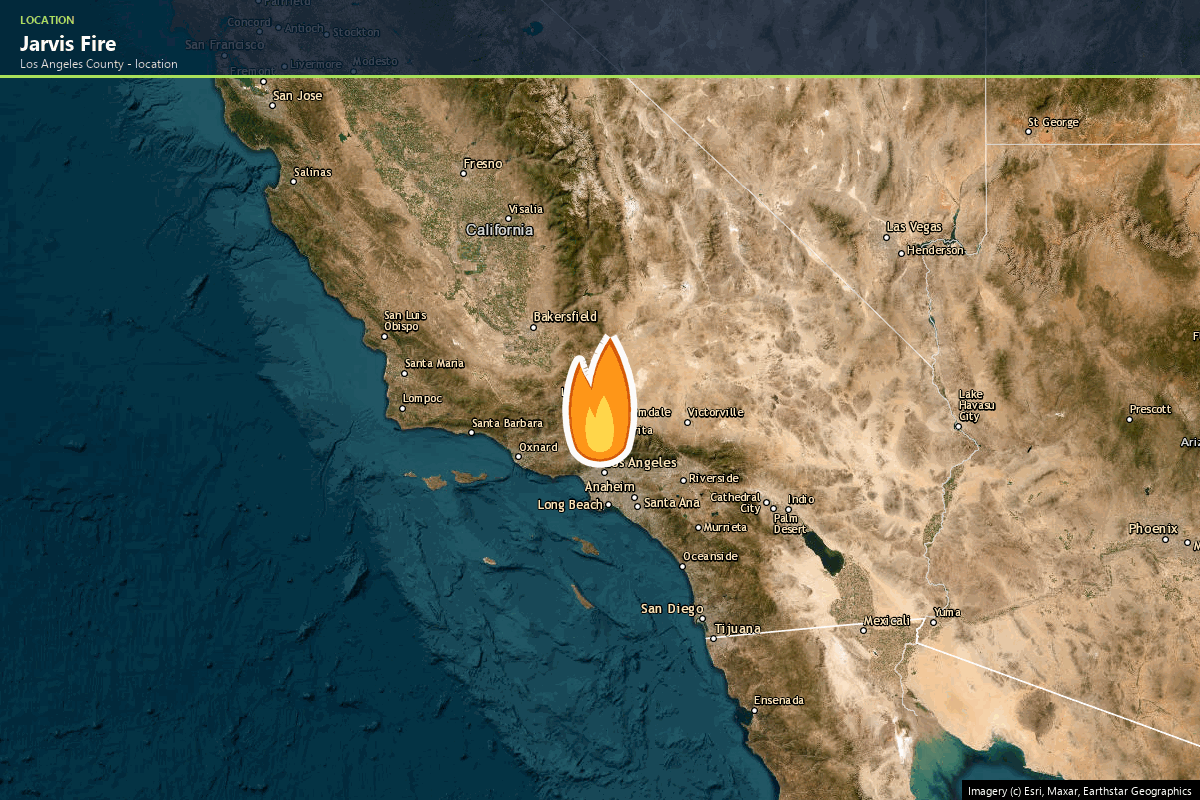
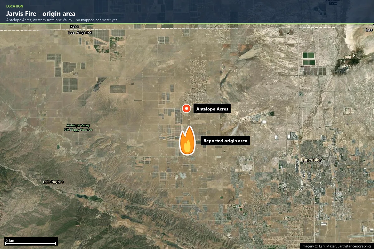
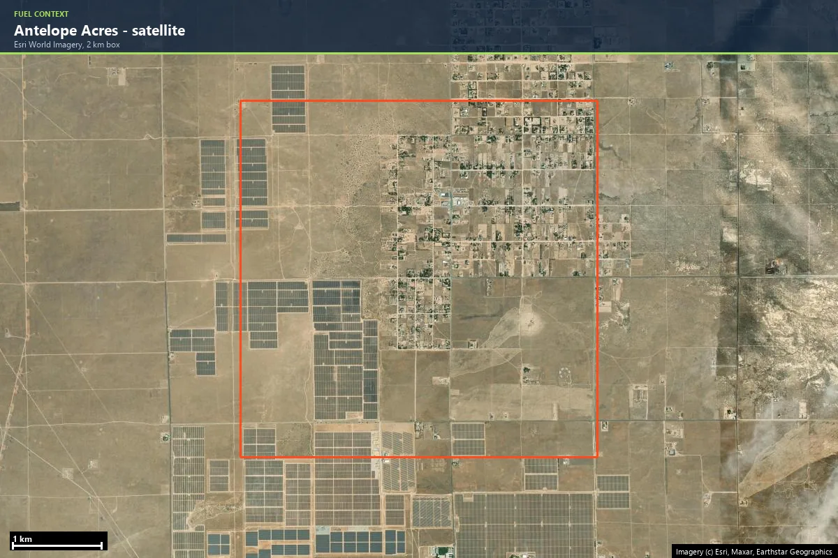
Antelope Acres sits on the flat western floor of the Antelope Valley — the high-desert northern corner of Los Angeles County, around 730 m elevation, on the grid of lettered avenues and numbered streets that covers the valley. Homes here sit on multi-acre lots along dirt shoulders, with horse corrals, small farms and solar arrays between them. It reads as open country, and in every direction the ground between the parcels is the same thing: annual grass, cured brown by August.
| Started | Monday, 10 August 2026, 3:57 p.m. |
| Location | Near W. Avenue H and 90th Street West, Antelope Acres, west of Lancaster |
| Size | About 362 acres |
| Forward progress stopped | 6:09 p.m. the same day — roughly two hours after dispatch |
| Evacuations | Warnings near W. Avenue G and south of W. Avenue D; downgraded, then lifted by about 6:15 p.m. |
| Injuries | One firefighter, minor burns to the hands; no civilian injuries |
| Structures | None reported damaged |
| Cause | Under investigation |
Those are the numbers of a fire that was caught. The more interesting numbers are the ones around it: 30 acres at 4:15, 300 twenty minutes after arrival, 362 within the hour. That growth curve — not the final acreage — is what this landscape does.
The preconditions: why this ground was ready to burn
No single thing produces a fire like this. The conditions stack, and each one is visible in public data long before an ignition.
1. This is a grass fire regime — speed, not flame height
Around Antelope Acres, the federal LANDFIRE vegetation map reads the surrounding landscape as roughly 58% California ruderal grassland — disturbed annual grasses, the kind that cure to standing straw by early summer — with desert scrub mixing in at the edges and only about a fifth of the ground registering as developed cover.
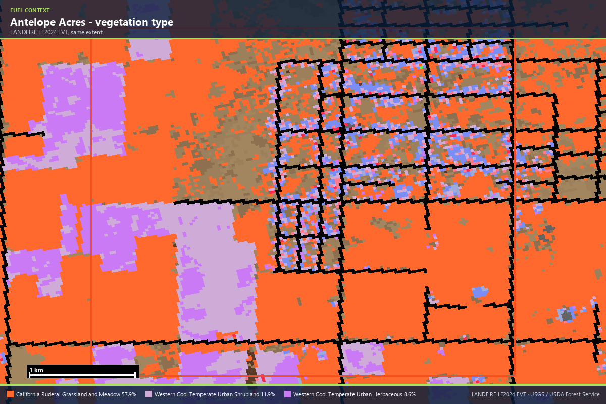
Cured annual grass is a light, flashy fuel. It does not make the 20-foot flame walls of a chaparral fire — the federal wildfire model puts the chance of flames over four feet at a parcel in the middle of Antelope Acres at just 10%. What it does instead is move. Grass carries fire faster than almost any other fuel in the state, which is exactly the behaviour in the dispatch log: 30 acres to 300 in the time it takes to set up an engine company. In grass country the question is never “how tall will the flames be” — it is “how much ground does it cover before the first engine gets water on it.”
2. The community is scattered through the fuel, not beside it
Look at the satellite frame again. Boulevard-style WUI communities — a dense town core with wildland at the edge — have a defensible boundary. Antelope Acres has the opposite geometry: homes dispersed across a grid of large lots, with continuous cured grass running between the parcels, along every road shoulder, up to every fence line. There is no edge where the wildland stops and the community begins; every parcel boundary is the interface. When grass fire moves through country like this, it does not besiege the community — it threads it. That is why a 362-acre fire, small by California standards, immediately put two evacuation warnings on the map.
3. Wind with a straight, flat run
The Antelope Valley is a wind corridor — hot afternoon air pulled across a dead-flat valley floor with nothing to break it. All three of this year’s fires near the community were afternoon starts that made their major runs within the first hour, and the June fire was pushed hard enough to cross a county line. On flat ground, wind owns the spread direction outright: there is no ridge shelter, no slope reversal, nothing between an ignition on Avenue H and a fence line a mile downwind except the grass that connects them.
4. The third fire in four months
- Corral Fire — 16 May 2026. About 130 acres near Antelope Acres, wind-driven, shelter-in-place orders for roughly two hours.
- Macy Fire — 5 June 2026. Started at Highway 138 and 110th Street West, ran to roughly 2,000 acres, crossed into Kern County, closed a stretch of Highway 138, evacuation warnings in two counties.
- Jarvis Fire — 10 August 2026. 362 acres, two evacuation warnings, stopped in two hours.
Three ignitions within a few miles of the same community, in twelve weeks — the one precondition the residents don’t need a dataset for. And it is not a 2026 anomaly: in June 2023 the Danny Fire burned about 1,600 acres at Avenue D and 130th Street West, a few miles north. On this ground the meaningful return interval for grass fire is measured in months, not decades.
5. The official record hasn’t caught up — and won’t for a while
Here is the part that should change how you read risk maps. None of the three 2026 fires around Antelope Acres — Corral, Macy, Jarvis — has a mapped perimeter in the federal WFIGS interagency system yet. Query the certified fire-history record around a parcel in the middle of the community and the most recent mapped fire is from 2013.
A homeowner who pulled the official history in April would have seen a thirteen-year quiet spell on ground that was about to burn three times in one summer. Perimeter mapping lags, small-and-fast fires are mapped last if at all, and a quiet record is not the same thing as quiet ground. Any risk product that reads only the certified past — and any homeowner who does the same — will systematically under-read a landscape like this one.
What this looks like as a property report
Those five conditions are what a wildfire-risk report measures — not for a region, but for one address. We ran a live Satelife report on a real parcel on West Avenue F, inside Antelope Acres, about three kilometres from the Jarvis Fire’s reported origin. We deliberately did not score the origin area itself: the cause is under investigation, and an address-level analysis there could read as implicating a household.
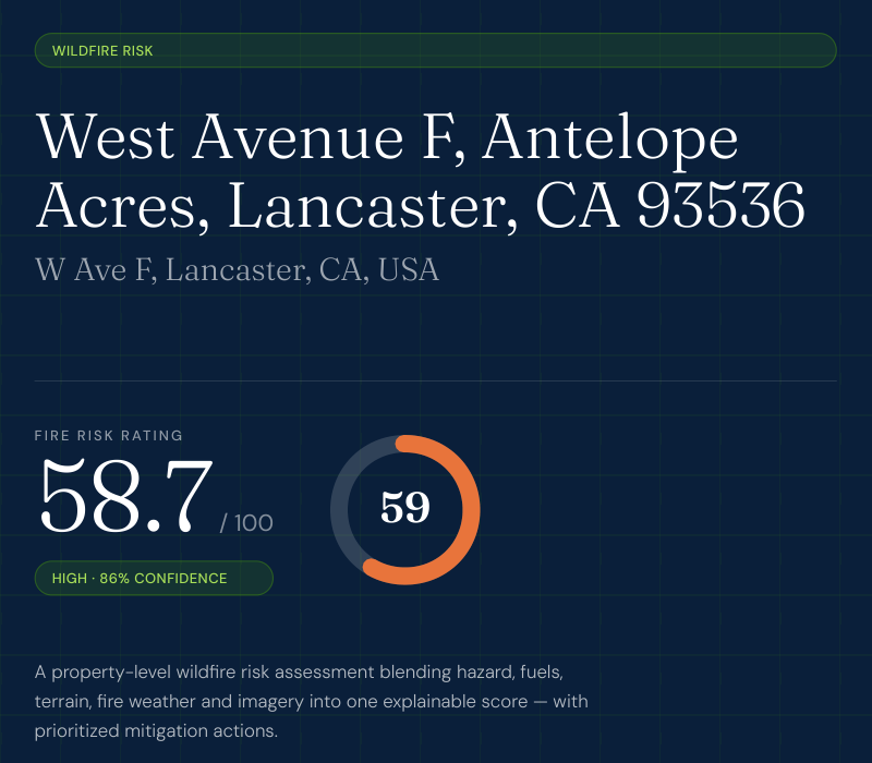
58.7 out of 100 — High, at 86% confidence. Three findings underneath it are worth unpacking.
The fire-history layer maxes out — on fires that end in 2013. The report found 40 mapped fire perimeters within 3.1 miles of the parcel, six of them in the last twenty years, and scores the layer 90 out of 100 — Very High — on recurrence alone. Every named incident in its table (May 2013, Lancaster and India 2011, three fires in 2009, back through 1998) predates this decade.
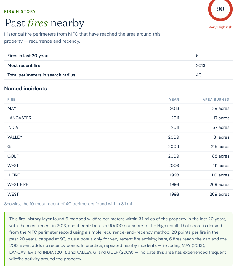
Read that carefully, because it is the article’s core point in one screenshot: even with this year’s three fires entirely missing from the record, the ground still scores Very High on the pattern of the past. The record lags; the pattern doesn’t.
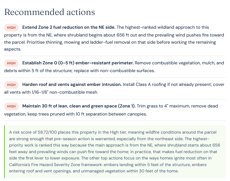
The score already knows which side the fire comes from. The report’s top-ranked action is not generic: extend fuel reduction on the northeast side, where shrubland begins about 656 feet out and the prevailing wind pushes fire toward the parcel. The AI-vision layer (74/100) read the street-level frames and found trees close to the structure, partial rather than comprehensive defensible space, and vegetation along the access frontage.
The quiet findings. The parcel sits in a mapped Moderate Fire Hazard Severity Zone under local responsibility — this corner of the county is on CAL FIRE’s map, unlike much of the high desert. Community preparedness comes back Moderate (52/100): Los Angeles County runs a countywide Community Wildfire Protection Plan, but the public record shows no community-level plan or Firewise USA site for Antelope Acres itself. And one honest caveat: the road-access measurement failed on this run — the public routing service that calculates fire-station drive time did not answer, so the engine flagged the gap and renormalised rather than inventing a number.
Wildfire risk by ZIP code near Antelope Acres
Satelife scores wildfire risk one address at a time, but these are the western Antelope Valley ZIP codes where this year’s fires and the grass-fire interface put homes at real, measurable risk. The caveat the whole article makes applies here too: the score is computed for your parcel, not your ZIP.
| ZIP code | Community | Why it is on the map |
|---|---|---|
| 93536 | Antelope Acres · west Lancaster · Quartz Hill | Origin area of the Jarvis (2026) and Macy (2026) fires |
| 93560 | Rosamond (Kern County) | Downwind of the Macy Fire’s run to the county line |
| 93532 | Lake Hughes · Elizabeth Lake | Foothill communities southwest, where grass meets chaparral |
| 93551 | west Palmdale | Grass-to-suburb interface along the valley’s southern edge |
| 93534 | central Lancaster | Urban edge parcels along the western avenue grid |
Get a Satelife wildfire-risk report for your address
If you live in country like this
The Jarvis Fire is out. The grass that carried it regrows every spring, and the wind is seasonal. The conditions will be back next summer; the only variable is the ignition.
Mow, and keep it mown. In grass country the single highest-leverage act is keeping grass short — four inches, not four feet — for thirty feet around every structure, and along the road frontage where most ignitions arrive. A grass fire that reaches mown ground drops its intensity to something an engine crew can stand in.
Work the first five feet. Embers and creeping grass flame ignite structures at the foundation line. Non-combustible ground cover against the base, clean roof valleys, screened vents.
Know your evacuation posture before the smoke. Twice this summer, warnings around Antelope Acres went from issued to lifted inside three hours. That speed cuts both ways — when the warning comes, the fire is already moving fast. Know your zone and your route on a quiet evening.
Have a second route you have actually driven. The avenue grid gives this valley more exits than a canyon community will ever have — but Highway 138 closed during the Macy Fire all the same. The grid only helps if you know which streets are paved through.
Do not read a quiet map as a safe address. The certified fire record near this parcel ends in 2013. The ground burned three times while that record stood still. If the official history looks calm, ask when it was last updated — or measure the conditions instead of the record.
Get a Satelife wildfire-risk report for your address · How we score
Incident facts: CAL FIRE incident page, and reporting by
CBS Los Angeles,
ABC7,
NBC Los Angeles and
MyNewsLA / City News Service.
Macy Fire facts: KTLA;
Corral Fire facts: NBC Los Angeles.
Fire origin point: NIFC/WFIGS incident record (IRWIN {F400A31A-F360-4B87-B0A9-FA10BD3D4CA8}); no WFIGS perimeter was
published for the Jarvis, Macy or Corral fires as of 12 August 2026. Property score from a live Satelife
wildfire_risk run, 12 August 2026. Layer sources: NIFC/WFIGS, CAL FIRE FHSZ, USFS Wildfire Risk to
Communities, USGS 3DEP, LANDFIRE LF2024, Open-Meteo ERA5, FEMA National Risk Index. Acreage and containment figures
describe a moving incident — check the CAL FIRE page for current status.
