Wildfire seasons across southern Europe, including Portugal, are lengthening and intensifying. For homeowners and real estate professionals, the question is no longer if wildfires will influence property decisions, but how to understand and manage the risk at a specific address. While weather sets the stage, property-level risk hinges on a handful of site and building characteristics you can assess and, crucially, improve. This article breaks down the five factors that matter most in the European context and offers practical steps to reduce exposure.
At a glance, the key determinants of property wildfire risk are:
- Terrain: slope, aspect, and position relative to ridgelines and gullies
- Vegetation and fuel load: type (notably eucalypts and resinous conifers), density, and continuity
- Fire history and ignition sources: evidence of past burns and proximity to likely ignition points
- Defensible space: how vegetation and materials are managed in the first 30 metres around structures
- Home hardening: the construction features that determine whether embers and heat can ignite your home
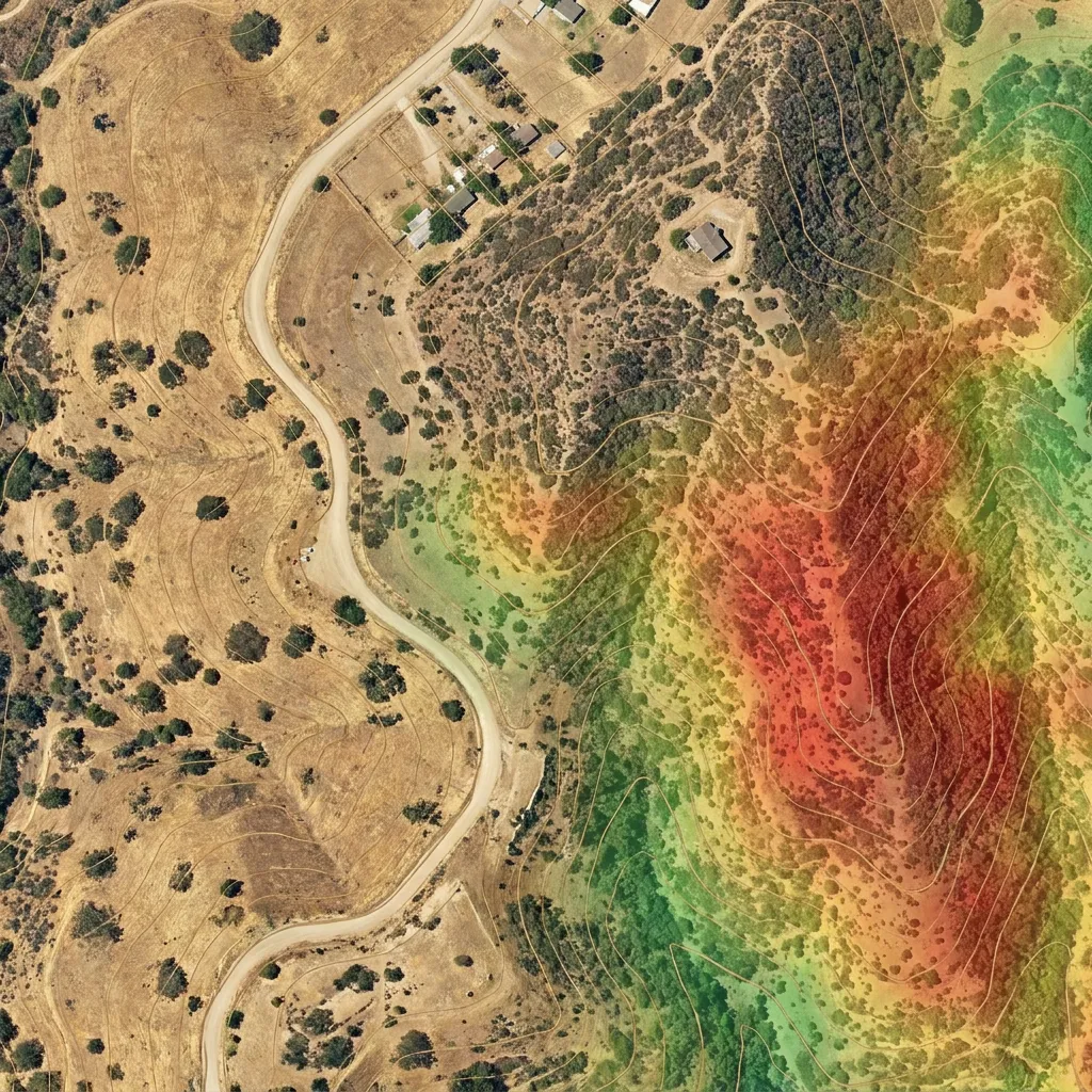
Satelite-based tools can now assess these factors consistently at scale. Satelife analyses terrain, vegetation, defensible space and likely home-hardening exposures from recent earth observation data to generate an address-level risk score, helping owners and buyers prioritise mitigation without guesswork.
1) Terrain: slope, aspect and exposure to ridgelines
Wildfire spreads faster uphill because heated air and flames preheat fuels above the fire line. The steeper the slope, the faster the advance. Terrain also shapes wind: ridgelines, saddles and narrow valleys can funnel and accelerate airflow, pushing embers ahead of the flame front.
What to look for
- Steep slopes beneath or immediately around the home. Fires on slopes can outpace suppression and erode evacuation margins.
- West- and south-facing aspects in Mediterranean climates, where fuels tend to be drier during peak season.
- Ridgetop or saddle locations that are exposed to winds, and bowl-shaped gullies that can trap heat.
- Canyons and draws that act as chimneys, concentrating heat and wind.
Useful primers on how topography amplifies fire behaviour can be found via the First Street Foundation’s overview of fire risk and geography and the Wildfire Risk to Communities resources on terrain influences. See: First Street Foundation: Fire Risk Assessment and Wildfire Risk to Communities: Topography.
Reducing risk
- Prefer building sites on gentler slopes or benches, set back from breaks in slope and gully heads.
- Create and maintain wider defensible space on downhill sides of buildings where fire is most likely to approach.
- Use driveways and terraces cut into slope as strategic breaks, and ensure clear, navigable access for responders.
2) Vegetation and fuel load: eucalyptus, conifers and continuity
Fuel drives fire intensity. In Portugal and across southern Europe, combustible plantations (notably eucalypts), resin-rich conifers and dense shrublands can produce intense flame lengths and ember showers. The risk escalates when fuels are continuous from wildland to garden to building.
What to look for
- Flammable species close to structures. International guidance notes that resinous plants such as junipers and pines ignite readily; eucalypts share similar volatile oils and shedding bark that can carry embers.
- Ladder fuels that let fire climb from grasses to shrubs to tree canopies.
- Heavy accumulations of leaf litter, bark strips, dead branches and woody debris.
- Vegetation continuity across property boundaries, including unmanaged adjacent parcels or plantation edges.
For background on how vegetation type and management shape fire behaviour, see USDA Forest Service: Fire Ecology and practical landscaping guidance from Firewise USA.
Reducing risk
- Break up fuel continuity. Keep the first 1.5–5 metres next to buildings clear of combustible plants and materials. Use gravel, stone and irrigated low-flammability plantings.
- Thin and prune. Raise tree canopies (e.g., 2–3 metres above ground where possible) and maintain spacing between crowns to limit crown fire potential.
- Remove fine fuels frequently during fire season: dry grass, leaves, bark ribbons and twiggy litter.
- Replace high-oil species near structures with low-flammability alternatives; maintain green buffers along access ways.
3) Fire history and ignition sources
A landscape that has burned before will likely burn again, especially where fuels regrow rapidly and ignition sources are common. Even without formal datasets, you can infer local risk by reading the landscape and surroundings.
What to look for
- Evidence of previous fires in the area: charred stumps, even-aged stands, or neighbours’ accounts of recent burns.
- Proximity to ignition sources: roads and verges, powerlines, recreation areas, agricultural burning, or industrial yards where sparks and machinery are present.
- Human access points that intersect with flashy fuels like dry grass, especially during heat and wind.
- Recurrent wind corridors that historically drive fire spread along valleys or over saddles.
Reducing risk
- Treat the interface between likely ignition points and your property as a priority buffer: mow grass, clear verge debris and maintain wide, low-fuel drive entrances.
- Collaborate with neighbours to create contiguous fuel breaks and align maintenance schedules.
- Time high-risk activities (strimming, welding, brush cutting) to cool, calm, humid parts of the day and keep suppression tools to hand.
4) Defensible space: the first 30 metres that matter most
Most homes do not ignite from a wall of flame but from embers landing on receptive fuels. According to guidance from CAL FIRE, more than 90% of homes that burn in wildfires are ignited by embers. Structuring the space around the building into zones significantly reduces ember and flame pathways.
Recommended zones
- Zone 0: 0–1.5 metres (0–5 feet). Keep this entirely non-combustible: mineral mulch or paving; no wood mulch, no shrubs under windows, and no combustible storage.
- Zone 1: 1.5–9 metres (5–30 feet). Space plants, prune lower limbs, and keep grass short. Separate shrubs from windows, eaves and decks.
- Zone 2: 9–30 metres (30–100 feet) or to your boundary. Reduce fuel loads with thinning, pruning and regular removal of dead material; create islands of vegetation separated by open areas.
For detailed defensible space practices, see CAL FIRE: Creating Defensible Space and NFPA: Defensible Space.
Practical touches that pay off
- Keep gutters, roofs and valleys free of leaves and needles during fire season.
- Store firewood and gas bottles well beyond Zone 0 and shield them from radiant heat.
- Use hardscaping (paths, patios, gravel strips) to interrupt vegetation continuity.
5) Home hardening: build for embers and heat
Defensible space addresses the fire outside; home hardening addresses how embers and heat interact with the structure itself. Materials and detailing often determine survival during ember storms.
Priority upgrades
- Roof: Replace wood shakes with non-combustible coverings such as metal, tile or slate; maintain tight-fitting ridge caps and sealed junctions.
- Openings: Fit ember-resistant mesh (≤3 mm) to vents; enclose eaves; install metal leaf guards; use tempered or multi-pane glazing for windows and skylights.
- Siding and decks: Select non-combustible or ignition-resistant cladding (e.g., stucco, fibre cement, brick) and ensure deck boards and substructures are protected from ember accumulation.
- Attachments: Treat fences, pergolas and trellises as potential wicks. Break wooden attachments with a short section of non-combustible material where they meet the house.
For construction guidance and standards, consult IBHS: Fortified Home and the International Code Council’s wildfire mitigation provisions.
Bringing it together with satellite-based assessment
Manual site walks remain valuable, but consistent, repeatable assessment is hard across multiple listings or a large portfolio. Satellite-derived analytics can help. Satelife automatically evaluates terrain exposure, vegetation type and continuity, defensible space conditions, and visible home-hardening risk indicators to produce an address-level wildfire risk score. That makes it easier to compare properties, target mitigation budgets, and track improvements over time after vegetation management or building works.
Due diligence tips for homeowners and property professionals
- Walk the terrain: Stand downhill and upwind of the home to visualise likely approach paths for flame and embers. Note slopes, saddles and gullies.
- Map the fuels: Sketch tree and shrub locations within 30 metres; mark ladder fuels and clusters that could carry fire to structures.
- Scan for ember traps: Gutters, roof valleys, under-deck storage, fence-to-house connections and open eaves.
- Read local history: Ask neighbours and local authorities about past fires and prevailing wind directions during major events.
- Watch the weather window: Hot, dry and windy days dramatically increase risk; keep maintenance current ahead of these windows. For situational awareness on fire-weather dynamics, see the National Interagency Fire Center resources.
- Plan access and egress: Ensure clear, wide driveways for responders and two-way evacuation, with vegetation set back from the route.
The bottom line
In Portugal and across southern Europe’s fire-prone landscapes, a property’s wildfire risk is largely determined by five tangible, assessable elements: terrain, vegetation and fuel continuity, fire history and ignition exposure, the quality of its defensible space, and how well the home is hardened against embers and heat. The good news is that most of these factors can be improved. Start with the first 30 metres, remove ember traps, and break up fuels. Use evidence-based guidance from organisations such as CAL FIRE, NFPA, USDA Forest Service, IBHS and ICC to prioritise works. Then monitor progress. With consistent assessment—including satellite-informed insights—you can reduce risk meaningfully, protect value, and make better property decisions in a changing climate.
← All posts