Wildfire seasons in Portugal and across Southern Europe are lengthening and intensifying. That reality makes an old truth feel new again: reducing risk is a shared task. In practice, homeowners, estate agents, local authorities, insurers and land managers each see a different slice of the problem. When those slices are combined—through shared data, consistent standards, and neighbourhood-level action—the result is clearer prioritisation and faster mitigation.
This article outlines a practical, collaborative approach grounded in five connected factors that consistently shape property-level wildfire risk in Mediterranean landscapes: terrain, vegetation (with a focus on eucalyptus), local fire history, defensible space, and home hardening. It draws on proven frameworks and open data that communities and professionals can use right away. In parallel, geospatial tools can automate much of the underlying analysis; for example, Satelife brings these five factors together from satellite and terrain data to generate an address-level risk score that supports property due diligence and neighbourhood planning.
Why collaboration matters in Portugal and Southern Europe
-
Shared information reduces blind spots. Near-real-time fire detections and historic burn layers can be accessed across borders in the European Forest Fire Information System (EFFIS), and complemented by global, satellite-based active fire feeds such as NASA’s FIRMS (FIRMS). When this evidence sits alongside local knowledge of access roads, water supply and fuel conditions, risk mapping becomes more accurate and actionable.
-
Common standards align action. Community programmes that embed consistent practices—such as defensible space and home hardening—have demonstrated value in reducing losses. Resources like Firewise USA offer widely adopted, property-scale guidance that can be adapted to European contexts (Firewise USA).
-
Community engagement amplifies impact. Experience from Southern Europe shows that organised, local collaboration improves preparedness and speeds mitigation work, particularly where resources are limited. Case studies on community roles in Mediterranean fire risk reduction illustrate how resident groups, municipalities and NGOs can work together on prevention and response (ScienceDirect case study; EU community-based fire management overview).
-
Insurers and public authorities can support incentives and clarity. Where insurers share non-sensitive insights on claims patterns and risk drivers, it can guide local priorities and improve market stability over time (GAO report on insurance and wildfire risk). Likewise, clear municipal guidance on vegetation management and access standards helps owners act with confidence.
The five connected factors every property should assess
No single metric explains wildfire risk at an address. The five factors below interact; understanding them together allows owners, buyers and local officials to target the most cost-effective improvements.
1) Terrain: slope, aspect, elevation and access
-
Why it matters: Fire generally spreads faster uphill; exposure on sun-facing slopes can dry vegetation; ridgelines and saddles can accelerate winds; and elevation can influence fuel types and seasonal dryness. Access also matters: narrow, single-track or dead-end roads can hinder evacuation and firefighting.
-
Collaborative actions:
- Combine municipal road data with local knowledge to flag constrained access and signposting needs. Simple, shared checklists help ensure clear addresses, adequate turning space and visible water points become neighbourhood norms.
- Use remote-sensing informed mapping to identify slope/aspect patterns that align with past fire runs and focus vegetation work where it reduces spread potential (see examples of remote-sensing applications in land management from the U.S. Forest Service for transferable concepts: USFS remote sensing tools).
2) Vegetation, including eucalyptus
-
Why it matters: Vegetation type, continuity and structure determine how readily fire can ignite and spread. In parts of Portugal and Southern Europe, plantations and mixed stands—including eucalyptus and pine—are common. Dense understory, continuous leaf litter and ladder fuels (lower branches and shrubs that carry fire from ground to canopy) increase exposure around homes.
-
Collaborative actions:
- Establish shared maintenance calendars for boundary lines, track verges and common areas to break up continuous fuels between properties.
- Prioritise thinning and litter removal in and around stands that accumulate surface fuels (including eucalyptus). Coordinate with neighbours to avoid “gaps” that leave one parcel unmanaged.
- Align practices with widely used defensible space principles (see below) to keep the immediate surroundings of structures clear of combustible materials. Property-level guidance and community templates are available via Firewise USA.
3) Local fire history
-
Why it matters: Past fires reveal where fuels, weather and topography have aligned to carry fire—and how communities have been affected. Reburn potential, ember travel corridors and typical ignition sources often repeat.
-
Collaborative actions:
- Review historic perimeters, burn severity and active fire detections using EFFIS layers for Europe (EFFIS) and global satellite feeds such as FIRMS. Share annotated maps at community meetings to connect data with lived experience.
- Use that evidence to prioritise roadside treatments, evacuation signage and water supply improvements where fires have repeatedly challenged access or suppression.
4) Defensible space
-
Why it matters: The condition of the first metres around a structure strongly influences the chance a home ignites from embers or direct flame contact. Consistent, shared practices across a street or village multiply the benefit.
-
Collaborative actions:
- Adopt simple, shared rules for the immediate zone around buildings—keep gutters clear, remove dry debris, separate combustible items from walls and under decks, and maintain spacing in shrubs and lower branches. Community-friendly guidance and zone-based frameworks are available via Firewise USA.
- Coordinate green waste disposal days so residents can act at the same time, reducing barriers and the chance that cut material remains on site.
5) Home hardening
-
Why it matters: Many homes ignite from embers entering through vents, gaps and roof coverings. Building materials and details—from roof type and condition, to vents, windows and fencing—can either invite or resist ember intrusion.
-
Collaborative actions:
- Promote checklists for ember resistance at sales, rentals and annual inspections: fit ember-resistant mesh on vents, maintain roof coverings, seal gaps, and consider non-combustible fencing where it connects to the house. General guidance is available through established wildfire safety programmes (Firewise USA; NWCG resource hub).
- Encourage neighbourhood-scale upgrades (for example, coordinated vent retrofits) to reduce overall ember load paths.
Turning individual actions into neighbourhood outcomes
Neighbourhoods and villages in Portugal and Southern Europe have shown that organisation matters. Community-based fire management—volunteer groups working with municipalities and civil protection—has improved preparedness and mitigation results in Mediterranean settings (Southern Europe community role; EU community-based fire management). Practical steps include:
-
Shared mapping: Produce simple, community maps marking access constraints, water points, assembly areas and priority vegetation breaks, drawing on EFFIS and satellite data for context (EFFIS; FIRMS).
-
Common calendars: Align vegetation work before peak fire weather and after seasonal leaf drops; combine with municipal verge maintenance where possible.
-
Consistent messaging: Use established education materials to keep advice simple and aligned across agencies and residents (NIFC education hub).
-
Partner roles: Where available, work with insurers and local businesses to support mitigation days or provide materials, following examples of cross-sector collaboration documented in risk management practice (GAO report).
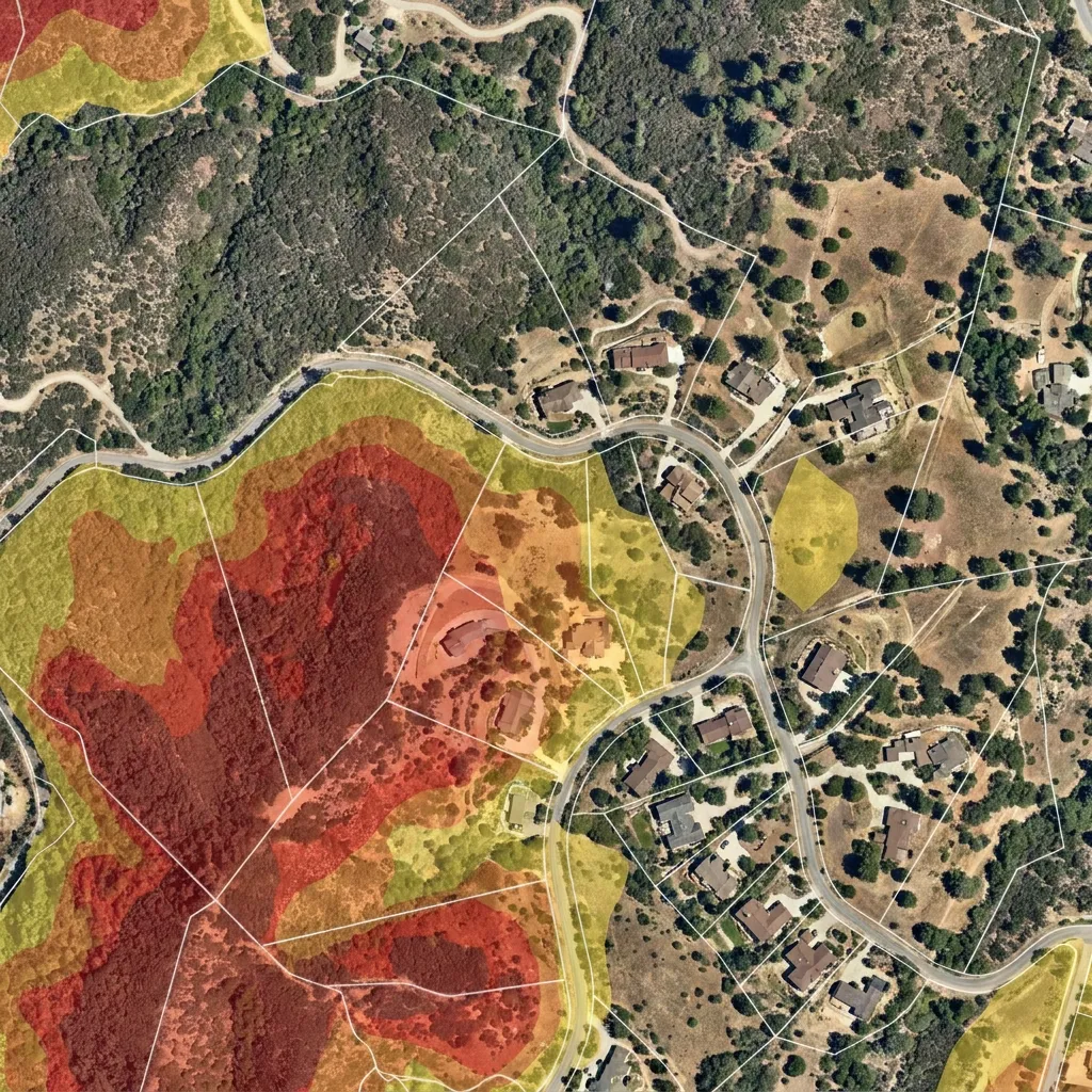
How shared data supports reliable, property-level scoring
Modern risk assessments bring the five factors together rather than treating them in isolation. Satellite-derived fire activity, vegetation condition, and terrain models can be combined with parcel footprints and building attributes to estimate exposure and highlight practical mitigations. Systems like NASA’s FIRMS provide global, near-real-time detections (FIRMS), while EFFIS offers harmonised European fire information (EFFIS). In this context, Satelife automatically analyses these five factors from satellite, terrain and vegetation data to generate an address-level wildfire risk score. The output can help homeowners, estate agents and municipalities prioritise inspections and plan defensible space work without replacing on-the-ground judgement.
A practical checklist for homeowners and real-estate professionals
For property viewings, pre-listing preparation, annual maintenance or community audits in Portugal and Southern Europe:
-
Terrain and access
- Confirm two-way access where possible; ensure property numbers are visible day and night.
- Note slopes facing the property and nearby saddles or ridgelines; plan vegetation work on upslope sides first.
-
Vegetation, including eucalyptus
- Identify dominant species on and adjacent to the parcel; where stands include eucalyptus or pine, check for continuous leaf litter and ladder fuels and plan regular removal.
- Break up fuel continuity along boundaries and driveways; maintain clear zones directly against structures.
-
Fire history
-
Defensible space
- Keep the immediate surroundings of buildings free of dry debris, firewood and flammable items; trim lower branches and separate shrubs to reduce flame paths.
- Coordinate with neighbours to treat shared verges and access tracks on the same schedule. Practical, zone-based guidance is available via Firewise USA.
-
Home hardening
-
Community coordination
- Share findings with local associations and municipalities; consider forming or joining a community group focused on seasonal mitigation and preparedness, following European examples of community-led fire management (Southern Europe case study).
The outcome we are aiming for
Collaboration does not replace individual responsibility; it multiplies it. When terrain, vegetation (including eucalyptus), local fire history, defensible space and home hardening are assessed consistently—and when that evidence is shared—residents make better choices, estate professionals give clearer advice, insurers and authorities target support where it matters, and communities across Portugal and Southern Europe become more resilient. Open data platforms such as EFFIS and FIRMS already supply much of the evidence required. The real progress comes when neighbourhoods and institutions use that evidence together, align around simple standards, and act on them year after year.
← All posts