Leading-edge Technology for Proactive Wildfire Management
Discover the cutting-edge capabilities of Satelife’s wildfire risk mitigation tool. By integrating high-resolution satellite imagery with AI-driven analytics and predictive models, we’re not just assessing risks—we’re actively providing solutions to manage and reduce them. Explore how our technology empowers proactive risk management, helping you protect assets and enhance safety measures effectively.
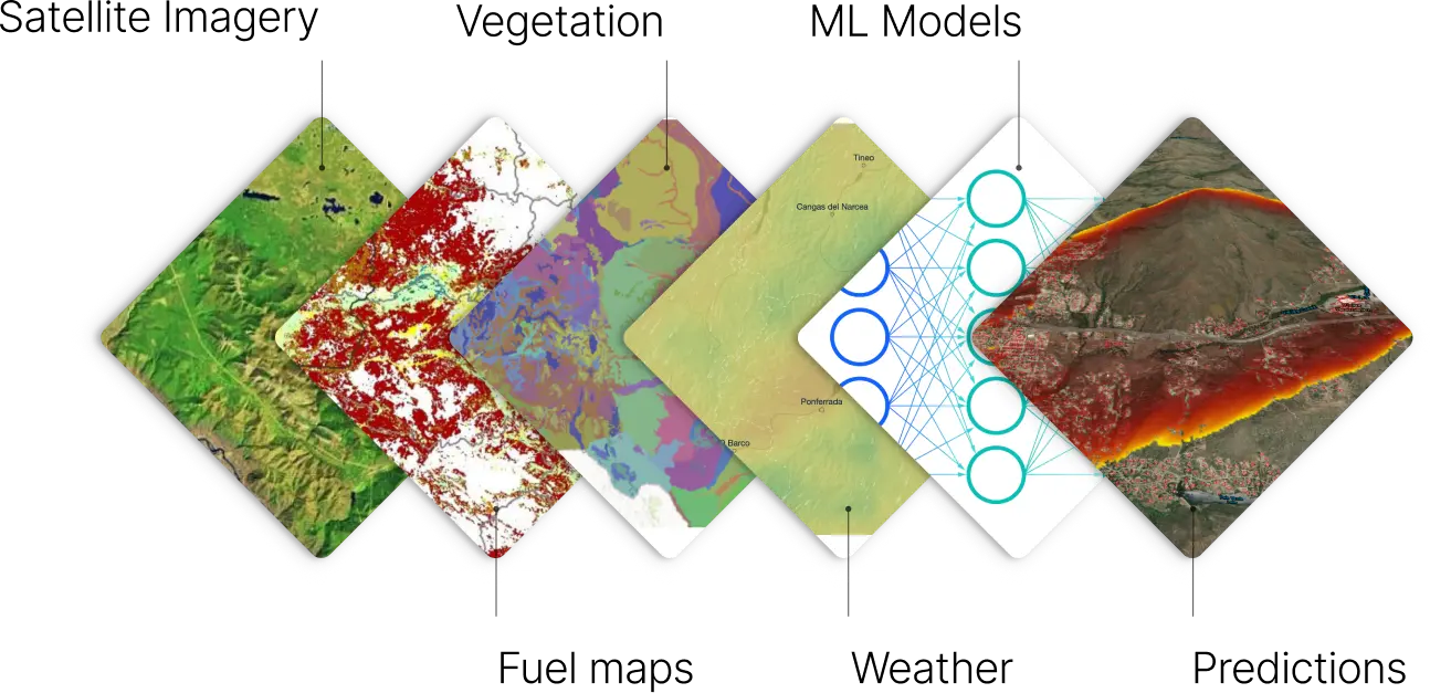
Core Technologies Powering Satelife
Satelife’s risk mitigation tool is rooted in a foundation of pioneering technologies:
Geospatial
Satellite Imagery
Utilizing ultra-resolution imaging to capture intricate environmental details, enabling higher precision in identifying wildfire risk factors.
Deep Learning Algorithms
Our neural networks process vast datasets, discerning patterns and predicting potential wildfire outbreaks.
Transparent Data
Satelife combines weather data, vegetation health, and historical fire trends transparently, crafting clear risk profiles without "black box" elements. This approach ensures clients fully understand the factors driving wildfire risks.
Real-Time Data Streaming
Utilizing edge computing, Satelife offers instant data processing and alerting for emerging wildfire threats, ensuring timely and effective response capabilities.

Tech in Action:
A Satelife Case Study
Satelife’s advanced technology will be using in California neighborhoods frequently threatened by wildfires, aiming to enhance community safety and reduce insurance costs.
Background
Neighborhoods, situated near dense forests in Southern California, experienced multiple wildfire events over the past decade due to its dry climate and abundant fuel sources.
Challenge
Residents face high insurance premiums with a growing threat of property loss, and local authorities needed a way to prioritize and implement effective wildfire prevention measures.
Solution
Satelife implemented its technology to enhance wildfire preparedness by providing detailed risk maps that highlight immediate fire risks using real-time data. The system also offered guidelines for vegetation control and property safety and established an instant alert system for emerging fire threats, significantly improving response times.
More features...
Seamless Integration with
Insurance Platforms
Satelife's API-first approach ensures a smooth and rapid integration with existing insurance systems, from CRM tools to risk management platforms. Our plug-and-play solution adapts to your tech stack, eliminating the need for cumbersome overhauls.
Holistic Risk Insights
Gain a comprehensive understanding of wildfire risks with our holistic risk insights. From terrain analysis to historical fire patterns, we provide a complete picture, empowering you to make proactive decisions to protect your property.
Interactive Risk Maps
Explore wildfire risks in real time with our interactive maps. Dive into specific areas, view detailed risk assessments, and access historical data, all at your fingertips for informed decision-making
Premium Optimization Tools
Take control of insurance costs with our premium optimization tools. Estimate insurance premiums based on our risk assessments and explore strategies to mitigate risks, ensuring you get the coverage you need at the best possible rate.
Investment Risk Analysis
Make confident real estate investments with our investment risk analysis tool. Predict potential risks and returns based on wildfire exposure, helping you evaluate the long-term safety and viability of properties.
Safety Certification Program
Join our safety certification program and showcase your commitment to wildfire safety. Gain recognition for properties that meet rigorous safety standards, enhancing marketability and providing peace of mind to buyers and insurers alike.